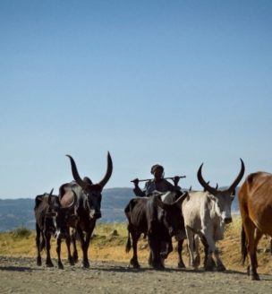
The Ethiopia Land Administration to Nurture Development (LAND) project is a 5-year project (2013-2018) working at the national and regional levels of government to further improve the legal and regulatory framework related to land tenure and property rights, thereby supporting the Government of Ethiopia’s and USAID’s goals of increasing economic growth, improving rural resiliency, and improving resource governance. The project works with pastoral communities in the Afar and Oromia regions of Ethiopia to support the formal recognition of customary land rights and strengthen the capacity of formal and customary pastoral land administration and land use institutions to engage in effective land and resource governance.
THE EVALUATION DESIGN
USAID is supporting a rigorous impact evaluation (IE) of the LAND project intervention in the Guji-Borana pastoral zone of Oromia to measure the key development impacts of project activities on communities and households related to enhancements in community resource governance, tenure security, improved land governance institutions, better land use planning, and increased negotiation capacity. The IE will employ a Difference-in-Difference methodology to measure impact, using baseline and endline evaluation data to compare changes over time between communities in Oromia that are receiving the LAND intervention and are not receiving the LAND intervention. Comprehensive quantitative and qualitative baseline data was collected prior to the start of LAND activities in Oromia from August to October 2014. The IE data collection instruments were designed to collect information on livestock holdings and herding practices, access to farmland and land management practices, access to grazing land and water points, rangeland conditions, and resource-related disputes. A Baseline Report, Design Report and other materials have been drafted and are available on this page.
DOWNLOAD THE BASELINE DATA
Baseline Data Collection: October 2014
The following baseline data sets and related documents are available for download:
Related survey instruments (surveys, discussion protocols, and interviews) and other evaluation documents can be downloaded below.
BY THE NUMBERS
This evaluation will assess impacts at the household and community levels using five primary sources of data:
- 3800 Household Surveys;
- 80 Key Informant Interviews, with village leaders and individuals involved in rangeland management;
- 50 Participatory Mapping Exercises, with herders, village leaders, and community elders;
- 75 Focus Group Discussions, with women, agro-pastoralists, & resource-constrained individuals; and
- Administrative data on land expropriation and other materials to provide background context.
KEY BASELINE FINDINGS
Bush encroachment and the expansion of human settlements and farming has reduced access to and use of rangelands. Although the Borana and Guji areas have experienced considerable conflict over land and boundaries in the past decade resulting in losses of human lives and the destruction of land, less than 10% of households surveyed indicated that they had experienced any land-related conflict in the past year. When conflicts did arise, the baseline results show that customary elders are more likely to handle relatively minor land and resource conflicts within an ethnic group, while larger-scale conflicts over administrative boundaries involving different ethnic groups are often taken to formal government offices resolution. Nonetheless, customary institutions continue to play a key role in creating rules and regulations over land and water and imposing penalties in cases of rule infractions. Lastly, the baseline analysis identifies very little outside private sector investment in land in the study region; however, local people are increasingly aware of the prospect that investors might come to the area.
SHARE YOUR RESEARCH WITH USAID
We encourage researchers who request and use this evaluation data to send a copy of any published research that draws on this data to landmatters@usaid.gov. We will post selected materials on this website to share with our visitors. Selected materials are marked “external” and inclusion of research using USAID data does not imply that USAID endorsement or support.