Five Lessons from Using MAST to Advance Women’s Land and Resource Rights

Research shows that strengthening women’s land and resource rights has a striking and positive impact on women’s empowerment. And yet, across much of the world, formal and informal laws and customs hinder women’s access to land and resources, leaving them unable to fulfill their full potential as agents of economic and social change. 

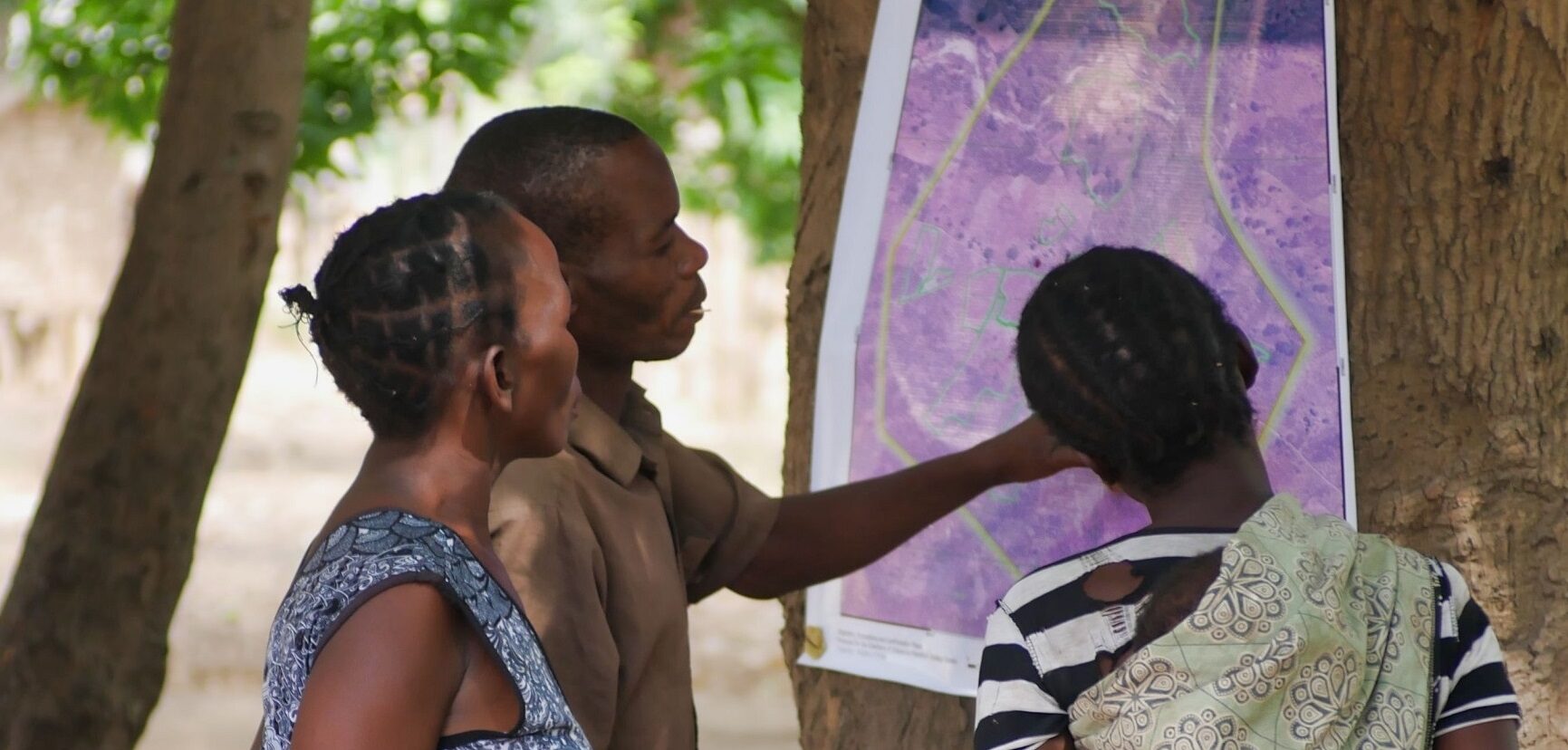
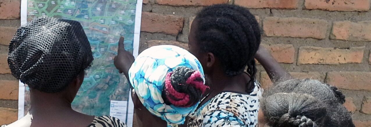
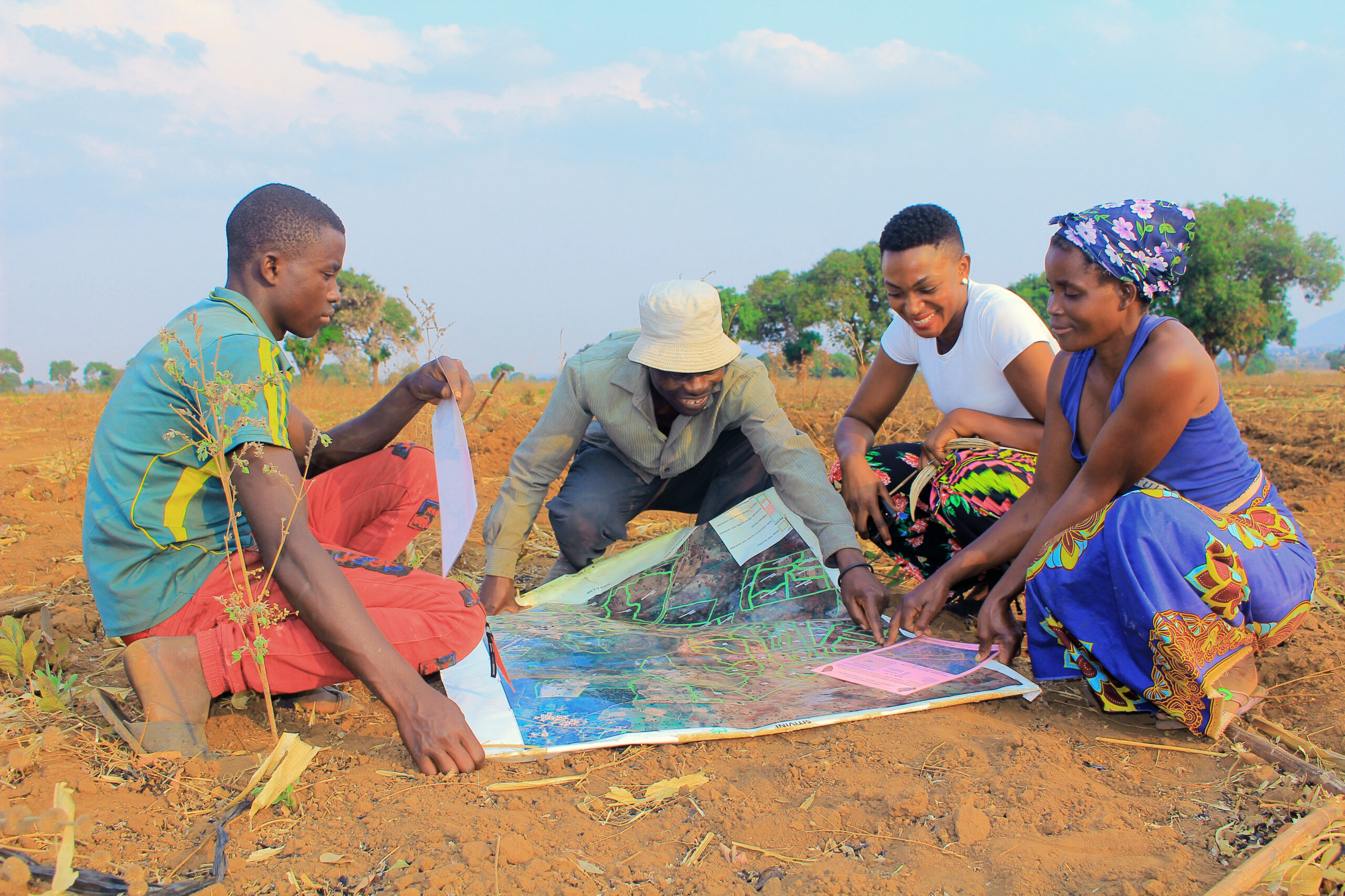
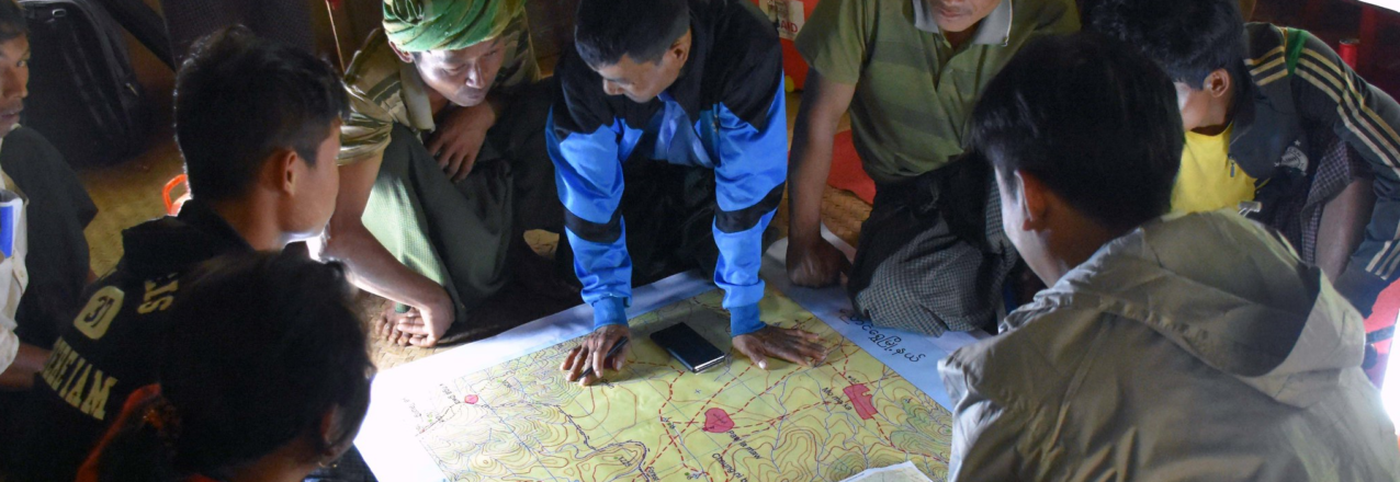
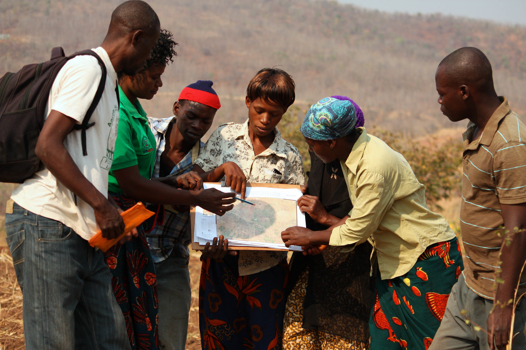
USAID is helping to address this longstanding inequity through its Mobile Applications to Secure Tenure (MAST), a blend of participatory mapping approaches and flexible technology tools that allows communities to document and secure their land and resource rights using a smartphone. MAST’s participatory mapping methodology emphasizes on-the-ground engagement and extensive training to empower citizens as data collectors and administrators and build their capacity to maintain land information and manage their land and resources.  

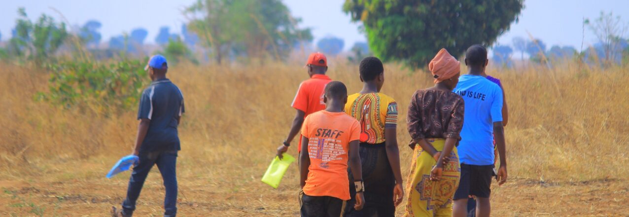
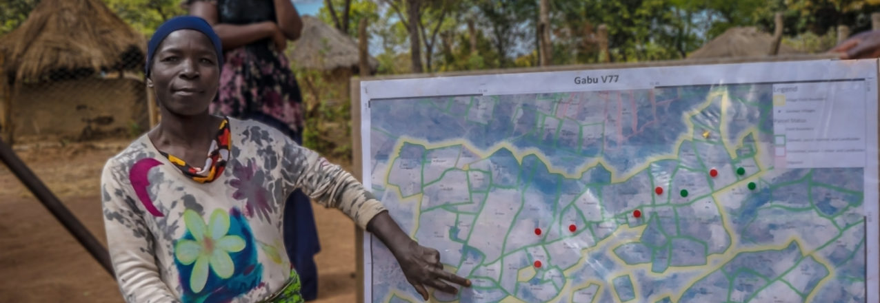
MAST engages local communities—with specific focus to the inclusion of women and youth as trusted local community members—who are trained to use maps and mobile devices to identify and record individual and communal land boundaries, land use, and ownership information. Mapping and information gathering takes place in the presence of land rights’ holders and neighbors and also engages marginalized groups, such as pastoralists. 

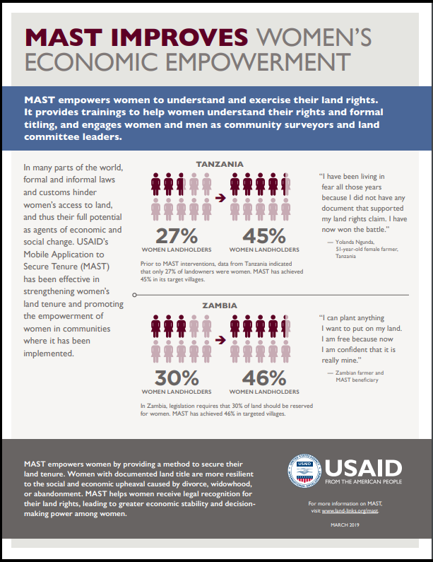
Across several countries where it has been deployed, MAST has already been effective in strengthening women’s land tenure and promoting the empowerment of women in communities where it has been implemented. In Tanzania, for example, the Land Tenure Assistance (LTA) activity employed a MAST approach to help women register their rights at the same rate as their male counterparts during the issuance of more than 100,000 customary land certificates (CCROs). In Zambia, the Integrated Land and Resource Governance (ILRG) project used MAST to ensure that half of all land documents in the project area were issued to women. And in Mozambique, the ILRG project implemented activities to help shift attitudes to be more supportive of women’s ownership of land. 

In March, USAID convened a learning exchange with partners from Tanzania, Mozambique, and Zambia who are actively using a MAST approach to document community land rights. Participants attending the exchange discussed the role of MAST in strengthening women’s land tenure and resource rights and how MAST might be made an even more powerful tool for promoting women’s empowerment. Here are five things that we learned from the discussion:

Meaningfully and directly engage women as project implementers

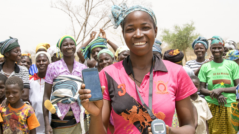
MAST allows for the direct involvement of citizens to map and register their land. Implementers in Tanzania, Mozambique, and Zambia have all found that including women in training, discussions, and mapping can help ensure that their rights are accounted for during the registration process. Recruiting women as para-surveyors and dispute adjudicators ensures that their perspectives and land claims are taken into account, while also providing them with short-term employment, transferable skills, and stronger feelings of confidence and empowerment. Although gender inequalities and gender norms that govern the behavior of girls and women (such as the division of household responsibilities) can make it difficult to recruit women to implement MAST, it is critical to encourage and promote their participation in these important community processes.

Intentionally cultivate women’s participation in meetings and training to promote their engagement

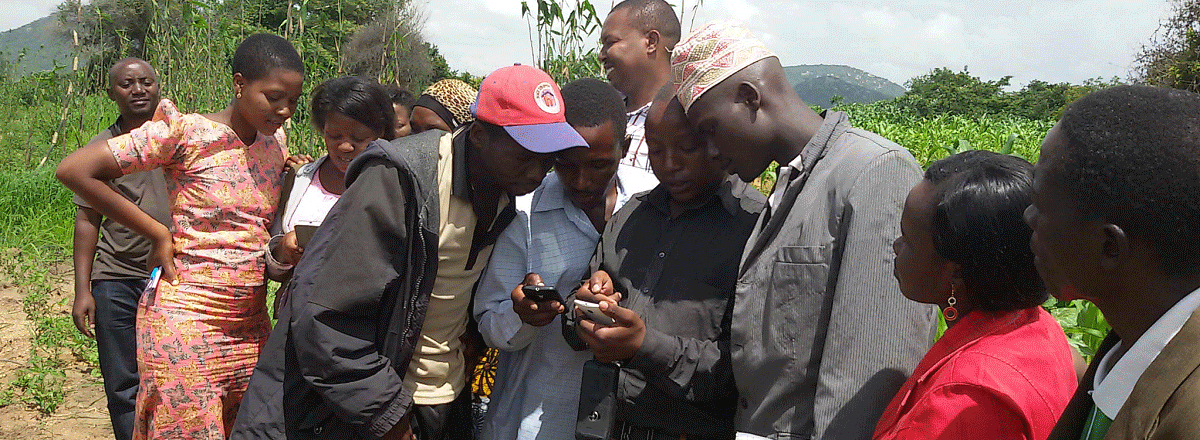
A key component of the MAST approach is training and actively engaging community members in discussions about community land resources, land use planning, land laws, and the importance of securing land rights. These trainings and discussions, which provide an important foundation for any mapping process, build important community awareness and buy-in to the process that is necessary for systematic land documentation. They also ensure greater participation and uptake by community members. Implementers have found that without employing specific means to intentionally engage women, these important, initial community sensitization meetings that seek to clarify land holdings and traditional rules are often dominated by men. Holding separate, female-only trainings can provide more space for women and youth to meaningfully engage with the MAST process and share their own thoughts, questions, and concerns. 

Tailor the engagement of women to the local context

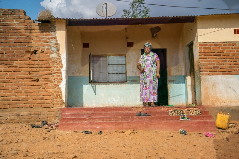
Where MAST has been implemented in Tanzania, Mozambique, and Zambia, local groups and communities maintain their own customs, matrilineal or patrilineal inheritance processes, familial structures, and class dynamics. Women often have responsibilities that are unique from men, which include childcare duties and domestic household management. Hence, it is important throughout the mapping process to engage women in ways that adequately account for their unique social roles, needs, and schedules. In addition, it is important to understand traditional customs and social rules that might prevent women from accessing and owning land. In some communities, for example, traditional customs and norms prohibit women from owning land in their own right. In these communities, encouraging joint registration between spouses (where both the husband and wife have their names listed on a land certificate) may be the best option to provide women with some level of tenure security.

Account for the time and effort required to change attitudes during project implementation 

Implementers across all three countries stressed that changing attitudes toward more positive perceptions of women’s land ownership takes time and effort. Since the laws and regulations governing women’s land ownership are not always known or well understood, it can take significant time to educate communities about these rules, which include the nuances of how strengthening women’s property rights can benefit entire households and communities. Multiple training sessions on the same topic might be required. Although this deliberate engagement can lengthen the time frame for land documentation using a MAST approach as compared to on-demand, targeted, and rapid land documentation, education is likely one of the most critical components to securing women’s land rights for the long-term. 

Engage men as champions of women’s participation and equality

It is well known that teaching men and boys to become champions for gender equality and women’s empowerment is essential to achieving gender-related development objectives and long-lasting social change. In fact, one of the eight operating principles listed in USAID’s Gender Equality and Women’s Empowerment Policy is to engage men and boys. Similarly, MAST implementers have found that cultivating male champions to support women’s participation in MAST, especially during early phases of the community mapping process, can help ensure greater and more meaningful participation by women. In addition, because MAST often challenges traditional gender norms around land ownership, there is a risk that women’s participation in the MAST process may encounter resistance in communities that might traditionally prevent women from accessing and owning land. Male champions, especially those in leadership positions, have been helpful in transforming traditional attitudes to promote more active participation of women and helping communities avoid pushback toward women and girls during and after the mapping process.

Strengthening Women’s Land Rights in Rural Tanzania: Results from an Impact Evaluation of USAID’s Land Tenure Assistance Activity

In rural Tanzania, as in many other low- and middle-income countries, land is a crucial asset that supports livelihoods and enables individuals and households to expand their economic opportunities. Most Tanzanians in rural areas are farmers who obtained their land through long-standing customary norms. However, weak land rights protections and a lack of documented ownership or use rights have long been seen as a source of local disputes, a constraint to how farmers use and invest in their land, and a barrier to household economic growth. A lack of land documentation can limit the participation of women and other vulnerable groups in agribusiness, and women often face higher risk of disenfranchisement of their land rights. How can the development community help?

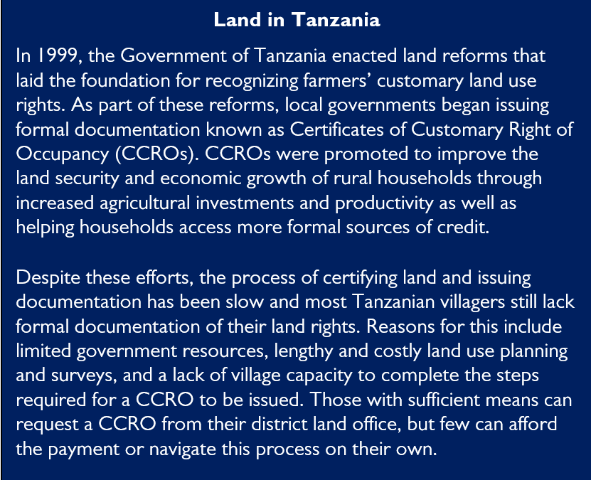
Since 2015, USAID has worked in rural Iringa District, the heart of Tanzania’s southern agricultural region, to strengthen land rights and systematically address the lack of land documentation. Over the past five years, USAID/Tanzania’s Land Tenure Activity (LTA) helped villages and the district land office demarcate more than 70,000 land parcels and register more than 60,000 land certificates (known as CCROs), all using USAID’s digital Mobile Application to Secure Tenure (MAST) technology. LTA represents one of the first times that MAST, which supports mapping and facilitation of the land documentation process using a mobile phone, was implemented on such a large scale.

A key question is whether this innovative approach to create stronger customary land rights has an impact on key development outcomes, such as tenure security (i.e., whether people feel confident no one will take their land or displace them), land disputes, and women’s empowerment. To assess LTA’s impacts on these outcomes, USAID commissioned Management Systems International and NORC at the University of Chicago to design and implement a rigorous impact evaluation. This IE is one of only two USAID land evaluations using a randomized control trial design.

LTA’s Impacts on Land Rights and Tenure Security

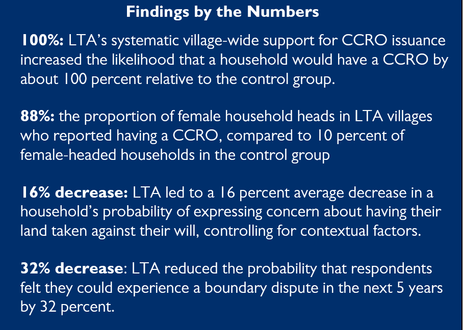
The impact evaluation of LTA has helped USAID measure the activity’s effect on land-related outcomes and understand how systematic certification of customary land rights affects smallholder farmers’ tenure security, investment decisions, empowerment, and broader livelihoods. With increasing land pressures and widespread concerns about land grabbing, knowing the impacts of formalized customary use rights is relevant to both farmers and policymakers.

The evaluation collected data via a panel survey of 1,361 households across 30 LTA villages and 30 control villages as part of a ‘gold standard’ randomized control trial design. The first round of data collection took place right before LTA began implementation in 2017. Endline data collection took place in February 2020, around 18 months after most households received their CCROs with LTA’s support. To understand how CCROs affect perceptions of land tenure security, land use, empowerment, and other key outcomes, the evaluation team interviewed the head of household and primary spouse.

A key evaluation finding is that LTA’s systematic, village-wide support was successful in helping most households obtain a CCRO. The proportion of respondents in LTA-supported villages with a CCRO in the evaluation sample rose from 3 percent at baseline to 86 percent at endline, compared with only 12 percent of control group respondents at endline. This underscores that CCROs remain largely out of reach for typical rural Tanzanian households in the absence of a systematic village-wide support program like LTA.

LTA’s support also led to a similarly large increase in formally documented land rights for women in LTA-supported villages as compared with the control group.

The evaluation results suggest that the increase in formalized land documentation also improved household tenure security. To look at common measures of tenure security, we asked household respondents how worried they felt about the risk of land being taken without permission in their community generally and for the land they personally use. The evaluation found significant improvements on both measures due to LTA’s support: an 18 percent decrease on average in a household’s probability of expressing community-wide concern over land expropriation and a 16 percent decrease on average in a household’s probably of feeling tenure insecure.

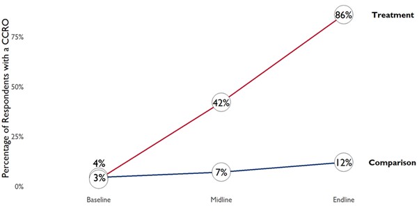
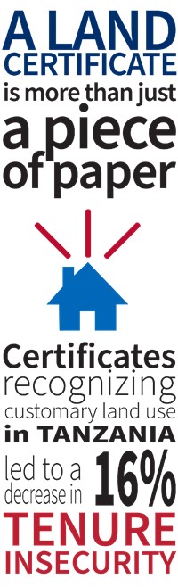
Tenure security improved for both men and women, and to a greater extent for female relative to male households heads. The evaluation also found a substantial increase in tenure security for female primary spouses supported by LTA. These improvements are especially important in the rural Tanzanian context, where women often have a harder time claiming and defending their land rights or exercising control over land decisions. Based on the evaluation results, USAID/Tanzania’s support for formalized customary land documentation seems to have not only expanded people’s access to CCROs but also led to more equitable access to land documentation in ways that allay gender-based concerns around land grabbing.

Among households that received CCROs, self-reported familiarity with land laws was also higher for female primary spouses than for the male household heads. This finding appears to reflect LTA’s emphasis and awareness raising around women’s land rights, together with opportunities for women to participate in trainings, meetings, and activities in Iringa related to land documentation.

LTA’s Impacts on Credit Access

The evaluation results related to credit are more nuanced and provide important learning around the role of CCROs in expanding rural villagers’ access to credit and economic opportunities. The evaluation found no evidence of a change in credit access (stable at around 13 percent for both groups and survey rounds) or amount (around 200,000 Tanzanian shillings or $86) as a result of the CCRO. Iringa District is similar to much of rural Tanzania in that borrowing from formal sources such as commercial banks is low and villagers are stymied by a lack of creditworthy business activities (as perceived by banks), poor business skills, and complicated loan processes. These results also point to wide gender disparities in borrowing sources and amount of credit obtained, underscoring opportunities for targeted programming to bring women’s economic empowerment on par with men. The null results on credit and differential access by gender suggest future programming should address these issues in conjunction with CCRO provisioning, and USAID’s Land Evidence for Economic Rights and Gender Empowerment (LEVERAGE) activity is conducting targeted learning on this topic.

Looking Ahead

USAID/Tanzania’s support to Iringa villages and the district land office in recognizing customary land rights has been critical in helping rural farmers protect their land, expand their livelihoods, and stave off uncompensated expropriation in the face of rapid urbanization and rural land use change. LTA’s achievements – including helping register around 60,000 CCROs across 30 villages, providing training to 220 women’s groups, and supporting the district land office to lead the technological and administrative process – are notable. The impact evaluation of LTA provides robust evidence of the initial impacts of CCROs to farmer tenure security and other near-term effects, and suggests the foundation has been laid for longer-term benefits to come. This rigorous evaluation suggests that formalizing customary land rights in the rest of Iringa District, and thousands of other villages across Tanzania, is well worth the effort.


USAID Brief Reveals Linkages between Gender-Based Violence and Documentation of Women’s Land Rights

Different forms of GBV are linked to land documentation, including economic violence such as a denial of land access, ownership, and inheritance rights, forced displacement, and property grabbing. Banner Photo credit CLEMENT CHIRWA – TETRA TECH

A USAID brief, published to mark 16 Days of Activism against Gender-Based Violence, reveals important lessons from land rights registration activities in Zambia

Securing women’s land rights is an important global development goal and has been linked to significant gains in women’s economic empowerment and community development. At the same time, the process of documenting these rights can create resentment and increase conflict not only between spouses, but also within families and communities, often leading to gender-based violence. This is one of the overarching lessons gleaned from land documentation data collected by USAID in recent years.

Photo credit CLEMENT CHIRWA – TETRA TECH

When the opportunity to register land rights is introduced to a rural community, it can create a sense of urgency and prompt people to confirm land boundaries and resolve long-standing disputes over ownership through a rapid process, risking the exclusion of people from registering their rights, especially vulnerable groups such as elderly and single women and women with disabilities.

“We have come to realize there is a damned-if-you-do and a damned-if-you-don’t dynamic at play. Either women are excluded from land, which is a form of gender-based violence, or if they assert their rights, they are subjected to other forms of violence ” explains Patricia Malasha, Zambia Gender and Social Inclusion Advisor for the USAID-funded program Integrated Land and Resource Governance (ILRG) and one of the authors of the brief.

“We can’t just ignore gender based violence in land documentation.”

For the last five years, USAID has promoted customary land documentation in Zambia, supporting partners to document the land rights using Mobile Approaches to Secure Tenure (MAST). This has resulted in registration of over 30,000 parcels of land benefiting 50,000 people, of whom nearly half are women. The approach is socially inclusive and promotes gender integration to ensure that women’s land rights are registered.

Since 2019, USAID’s local partners have collected qualitative data and stories on gender-based violence while documenting customary land. The results, presented in the brief Gender-Based Violence and Land Documentation and Administration in Zambia, provide useful lessons and recommendations that have the strength to inform and guide how rights documentation processes proceed.

The personal stories illustrated in the brief are powerful examples demonstrating that the protective role of secure land rights and their ability to increase women’s power to renegotiate relationships is not straightforward. Well-intentioned pressure to reach high targets of parcels documented in short periods of time can increase the risk of conflict within communities, as well as gender-based violence. Similarly, pushing for the inclusion of women in land records or joint titling without engaging in parallel work to address broader gender norms may inadvertently put women at risk.

The brief was published in order to continue the dialogue around gender-based violence and as part of the International Day Against Violence Against Women on November 25, and the following 16 Days of Activism that finalize on Human Rights Day, December 10.

USAID will continue to identify and mitigate risks related to gender-based violence and its relationship to land rights registration activities over the next three years under the USAID Integrated Land and Resource Governance Program across intervention countries.

Click Here To Download The Full Brief


Ensuring Girls Inherit their Fair Share in Zambia

Banner Photo: Female community members at Chiuye village in Nyamphande Chiefdom of Petauke District check over their parcels during the objections, corrections, and confirmation process. (Photo credit: Chika Banda/PDLA)

USAID-funded land documentation programs help secure daughters’ land inheritance rights and promote girls’ empowerment on the International Day of the Girl Child

When it comes to women’s land rights and gender norms, John Mwanza was no different from most men in many areas of rural Zambia. A local village leader, he believed that despite the bonds of marriage, his wife should not be granted ownership rights to his family’s land. John had also never considered that his daughter should be a beneficiary to the family’s land. He believed that one day she will marry a man who might end up taking the land from his family. Now, through the USAID-funded Integrated Land and Resource Governance (ILRG) program, Mr. Mwanza has had a change of heart and become a champion for ensuring that women, and particularly daughters, have rights to the land they live on.

CDLA Gender and Social Inclusion Officer Lucy Phiri (in white) looks over a community map with the Mwanza family. With USAID support, John Mwanza has registered his wife (in blue) as a person of interest and his eldest son (pictured) and his youngest son and daughter (not pictured) as landholders of the family land. Photo credit: Clement Robson Chirwa / ILRG 2020

Zambia has a dual land tenure system, with state land administered by the government and customary land administered by chiefs and other traditional leaders. Gender norms in both matrilineal and patrilineal societies hinder the land rights of women and their daughters. Family loyalties are defined by blood, and since wives are not directly related to the husband’s family, they are often excluded from land documentation. When women marry they are expected to move to their husband’s family land, so girls are also precluded from land inheritance. In most cases, only a man’s relatives and male descendants are allowed to inherit family land.

“Land is the bottleneck and the barrier that we could never get past. Everyone wants more, so they take advantage of the widows and make claims. Prior to CDLA’s arrival, each week, dozens of households lined up seeking resolution to conflicts over field boundaries. Now there is peace in the chiefdom.” Chieftainess Mkanda, Chipata District, Zambia.

Conversations about deep-seated gender biases are part of the USAID program’s efforts to increase land tenure security in Zambia and the wider strategy to challenge harmful gender norms that prevent women from owning and fully benefiting from land and natural resources. The ILRG program is working with local civil society organizations, such as the Chipata District Land Alliance (CDLA) and Petauke District Land Alliance (PDLA), to advance women’s social and economic empowerment through land rights in Zambia’s Eastern Province.

Customary land documentation helps low income farmers protect their land and provides security in the event of ownership conflicts, which is common among neighbors, relatives, and outside investors. For women, secure land rights offer opportunities to access financial services and higher social standing, and shift household and community-level decision-making dynamics on how resources are spent and distributed. Secure land rights are thus an important pathway for women’s economic empowerment.

Through ILRG, USAID is pioneering customary land documentation by employing socially inclusive GPS and smartphone technology known as MAST, or Mobile Approaches to Secure Tenure. The approach integrates gender in land documentation to ensure women’s interests in land are registered, even in male-dominated systems. The approach also promotes the rights of all of their children and encourages women’s leadership in local land governance. The MAST land documentation process asks chiefs, village leaders, and landowners to participate in social gatherings and community dialogue sessions that break down gender stereotypes and reinforce the idea that equal land rights benefit the family and the community.

Photo: Sandra Coburn / Cloudburst

“It’s our job to remind the community that by registering their wives and daughters as persons of interest or landowners, it makes sense from the family’s perspective to secure and protect their land,” says Adam Ngoma, CDLA coordinator.

In John Mwanza’s village, the CDLA staff explain how excluding girls from family land will have serious implications on their future, limiting their livelihood opportunities and increasing their vulnerability to gender-based violence.

The participatory sessions helped men like John Mwanza, the village leader who would previously never have considered allowing his daughter to inherit his land, to appreciate gender equality and to request CDLA to list his wife as a person of interest – which protects her rights to occupy and use the land – and his daughter as a landholder. Now, his daughter will grow up secure land rights, which she can use for economic opportunities in the future.

A Daughter’s Tale
“We are in a modern era so no need to deprive women and girls of what they deserve. Registering my wife as a landholder has helped cement my marriage and the love between my wife and I.” Weka Ziwa, Nzamane, Chipata District, Zambia. Registered all six of his children during customary land documentation 
Zambia, Chipata: Chieftainess Mkanda at her palace. Across much of Zambia, Customary systems prevail and they do not necessarily align with the formal legal system. While some customary tenure systems limit the rights of women and vulnerable groups, they provide an important form of local governance. A USAID project to strengthen governance in both the formal and customary systems and promote sustainable stewardship of natural resources, worked with the Chieftainess and other leaders to map and document land rights within their chiefdoms. Photo credit: Sandra Coburn

In another corner of the Mkanda Chiefdom, 41-year-old Charity Mbewe has worked hard to become the village headperson and lead her community. When her father recently died, the family farm went to her brothers, because according to local gender norms daughters do not inherit land. Although Charity has four children, she never paused to think that her children could have benefitted from her deceased father’s land.

When CDLA began land documentation in her village, she worried that her female children might face a similar fate: powerless to inherit land or worse, one day become a landless widow.

Thanks to USAID’s efforts to integrate gender into customary land documentation, Charity Mbewe, worked with her siblings to include her daughters’ names as landholders of her father’s farm. Charity’s oldest daughter is married but has no land, proving that marriage does not guarantee that women can access land. In fact, her inclusion in the title of her grandfather’s farm will be the first time she will be a landholder. 


Better Biodiversity Integration Through Geospatial Analysis

As USAID transforms, cross-sector programming is more important than ever, and this is especially true for environment programming. The USAID Office of Forestry and Biodiversity, and the Bureau for Latin America and the Caribbean, have developed a new guide that explains how to use geospatial analysis throughout the program cycle to support integration of biodiversity conservation with other development sectors.

Geospatial analysis is the gathering, display and analysis of data with a spatial component. These data range from satellite imagery, to global datasets on forest cover, to geographically referenced census information. In addition to its widespread use for program design, geospatial analysis is a powerful tool for bringing sectors together by visualizing and analyzing the overlaps between sectors.

This guide is intended both to support the work of geospatial specialists, and to help USAID staff make the case for geospatial analysis during integration for USAID technical offices, program offices, and front offices. Though the guide was written with biodiversity programming in mind, it has many lessons that might be broadly useful to USAID staff as they integrate their programs.

Download the Full Guide


Importance of Property Rights for Women

This editorial was originally published on the Voice of America Website

Changing property and inheritance laws “may be the most critical” step in ensuring “women’s full and free participation in local economies.”

The right to own property is a key necessity to fully integrate women into a nation’s economy. Speaking on a Women’s Global Development and Prosperity Initiative panel, better known as W-GDP, to announce new projects, Advisor to the President Ivanka Trump noted that changing property and inheritance laws “may be the most critical” step in ensuring “women’s full and free participation in local economies.”

USAID Administrator Mark Green also affirmed the importance of land rights in women’s economic empowerment: “We talk about the journey to self-reliance and helping countries lead themselves. No country is self-reliant if it isn’t tapping into more than half of its population.”

CEO Chris Jochnick from Landesa, an NGO that is implementing a land rights project, said W-GDP funds put in Liberia, Mozambique, Zambia, Tanzania, and Ethiopia will ensure women’s property rights through revised laws and regulations. The project will affect the ability of millions of women to own, inherit, or use land across Africa. “Approximately 100 million women live in these five countries,” said Mr. Jochnick, “and this project should go a long way to bolstering their entrepreneurship and economic opportunities.”

There are 90 countries where, either by law or by custom, women can’t own, inherit, or manage land. As a consequence, these women are relegated to second class citizenship and life in a constant state of vulnerability:

If we want to empower women we have to start with this fundamental inequity. . . .mostly women living in poverty live off the land. Land to them is a home, survival, an income, a chance to feed and clothe and house and educate their children. Land is also a chance for entrepreneurship.”

A recent success story is Cote D’Ivoire, where a new marriage law will now enable women to inherit and acquire property, said Advisor Trump:

“This is great work being done on a local level, actually, through funding with local NGOs and advocates in Cote d’Ivoire and [Millennium Challenge Corporation]. I visited there this spring and reinforced the essential nature of changing this law.”


Learn More about other USAID’s works on Women’s Empowerment 

MAST IMPROVES WOMEN’S ECONOMIC EMPOWERMENT

MAST empowers women to understand and exercise their land rights. It provides trainings to help women understand their rights and formal titling, and engages women and men as community surveyors and land committee leaders.

Learn More


Understanding Landscapes Using Spatial Data

This blog was originally published on ClimateLinks

Landscapes and the complex, interlinked spatial units that comprise them are changing at an accelerating rate. Land use change, especially deforestation and forest degradation, are among the main contributors to global greenhouse emissions. Quantifying and monitoring forest conversion and better understanding the drivers of these changes is therefore paramount to supporting sustainable landscapes initiatives and increasing the potential for carbon sequestration globally.

The increased availability of spatial data and satellite imagery, combined with advances in computing power, are creating unprecedented opportunities for monitoring of deforestation and forest degradation at global and regional scales.

Forest Monitoring

The USAID-supported Global Forest Watch platform enables thousands of users to access and share reliable forest information globally. Other geospatial platforms provide updated forest loss information for tropical regions, such as the Terra-I platform and the Monitoring of the Andean Amazon Project (MAAP).

Development programs are also using geospatial data and analysis at the country level to enhance understanding of forest degradation. In India, an estimated 41 percent of the total forest has been degraded to meet the country’s growing demand for fuelwood and timber. There, the USAID-funded Forest-Plus initiative uses geospatial analysis and technology to develop and rapidly share forest inventories and forest carbon estimates.

Cross-Sector Integration

Data provided through global monitoring platforms can help practitioners integrate development programming across sectors, identify high priority landscapes and monitor landscapes with high potential for carbon sequestration and/or ecosystem services. In Cambodia, USAID used spatial analysis and a landscape approach to integrate programming across sector objectives and to define the extended Prey Lang Landscape, which includes the Prey Lang Wildlife Sanctuary, protected areas and catchment basins that provide ecosystem services and are hydrologically connected to the Tonlé Sap ecosystem.

Empower Communities

Local communities—the people who live on, manage and use landscapes and resources—are central to understanding complex landscape dynamics and addressing key drivers of land use change. USAID and other development agencies are increasingly using geospatial analysis and technology for crowdsourcing and community-based approaches, such as USAID’s MAST initiative, a participatory approach that empowers communities with the tools to quickly, accurately and transparently map and document their own land and resource rights.

Test Development Hypotheses

Geospatial analysis can also be used to generate evidence aimed at testing the theory of change and understanding the potential impact of intervention within landscapes. USAID recently used geospatial analysis as part of an impact evaluation in Zambia to analyze community perceptions of forest tenure and forest condition. Findings showed that more secure forest tenure is associated with better-reported forest condition.

Guidance and Requirements

USAID missions and partners have access to a growing number of resources to support landscape analysis and to build capacity for spatial data collection and management. USAID developed new data guidance and specific location requirements for data collection at the activity level, which helps improve decision-making and adaptive management throughout the development program cycle. This strengthens USAID’s ability to plan, deliver, assess and adapt development programming in an accountable, transparent manner.

USAID missions can also access specialized geospatial analytical and capacity building support within the Bureau for Education, Energy and the Environment/Land and Urban office or the USAID Geocenter. Missions can also leverage the capacity and expertise of the SERVIR hubs, a community of practice comprising over 50 specialists, and a consortium of YouthMappers that connects student mapping charters around the world.


MAST: Supporting Community Forest Management in Liberia

By the USAID LTS Team

Liberia depends on its forests. The forestry sector contributes 10 percent of the country’s GDP. One in three rural Liberians (1.5 million people) live in forested areas and rely on forests for a significant source of their livelihoods. And Liberia’s forests are a global biodiversity hotspot, comprising more than half of West Africa’s remaining Upper Guinean tropical forest. Yet Liberia’s forests remain under serious threat.

Notwithstanding its importance to the country, sustainable forest management – at both national and community levels – remains a considerable challenge, in part due to lack of reliable information regarding forest condition and resources rights.[1] Moreover, communities have limited information about their customary resources, despite the recent passage of the Land Rights Act of 2017 (LRA), which provides the legal framework for forest communities to document land boundaries outside of the forest conservation areas. In response to this dilemma, USAID is testing its Mobile Applications to Secure Tenure (MAST) initiative in Liberia to help communities define, map, record, and document their resources to enhance biodiversity conservation while improving community forest management. MAST provides a participatory framework and flexible tools that empower citizens in the process of documenting and managing their forest resources. The end result is clearer, stronger rights and greater incentives to invest and conserve resources.

The MAST Liberia pilot works closely with USAID/Liberia’s Forest Incomes for Environmental Sustainability (FIFES) program and villages in Blei Community Forest in Liberia’s Nimba County to test participatory methods that enable communities to collect, validate and manage information regarding community forest and customary resources. While communities surrounding Blei Forest highly value forest protection, they are faced with the need to balance conservation with the development of alternative, resource-based sources of income. The pilot aims to enhance the community’s ability to clarify the use of forest and customary resources, to monitor their condition, and to make informed decisions. MAST can help consolidate land and forest resource information and provide an important platform to engage stakeholders in making critical decisions regarding their use.

Want to learn more about MAST? Visit the MAST Learning Platform at:

[1] Id.

Transforming Land Rights Management in Tanzania

In Tanzania, smallholder land registrations are critical to protecting local land rights. However, since passing the Village Act in 1999 to provide for the management of village lands, the process of registration has moved slowly due to limited operational capacity. To bring the law into full effect, procedures for registration and administration need to be low-cost, simple, and equitable. In addition, the land registration system must support future transactions and allow registers to be maintained at village and district levels.

Under the Land Tenure Assistance (LTA) activity, funded by the U.S. Agency for International Development (USAID), DAI is modifying an existing tool for mapping smallholdings and detailing ownership claims—the Mobile Application to Secure Tenure (MAST)—which USAID first piloted in Tanzania. This tool will be linked to a low-cost land registry tool, the Technical Register Under Social Tenure (TRUST), which DAI is developing at the district level and plans to scale up to other areas of the country. The outcome is a low-cost, participatory land registration process that is transforming the way land rights are managed in Tanzania, with the potential for adaptation elsewhere.

Read the full story


What’s new with MAST?

USAID’s Mobile Applications to Secure Tenure (MAST) initiative started small. Launched in 2014 in three pilot villages, the initial goal was to test a simple but powerful idea: with some training and support, could underserved communities use mobile phone mapping technology and participatory approaches to document and secure their land rights? Five years and four countries later, that initial idea has grown into a powerful suite of tools and programs that are achieving remarkable results, from women’s economic empowerment in Tanzania to forest conservation in Liberia.

Here are the latest updates on MAST from around the globe.

Land Certification and Access to Credit in Tanzania

In Tanzania, USAID’s Land Tenure Assistance (LTA) program has now used MAST to map and document almost 63,000 land parcels. With their property rights secure, people – particularly women – are more empowered in the economy.  “The certificates issued by LTA have paved the way for rural Tanzanians to improve their farms and start small businesses by leveraging their land to access credit. The project is working with local banks to encourage the acceptance of certificates as collateral and with villages to raise awareness of the new loan opportunities. Farmers have already begun using their land-backed loans to purchase fertilizer, high-quality seeds, tractors, and other agricultural inputs to raise their productivity and their incomes.” LEARN MORE.

Supporting Community Forest Management in Liberia

Liberia depends on its forests. The forestry sector contributes 10 percent of the country’s GDP. One in three rural Liberians (1.5 million people) live in forested areas and rely on forests for a significant source of their livelihoods. Under a new pilot program, USAID/Liberia is using MAST to help communities define, map, record, and document their resources to enhance biodiversity conservation while improving community forest management. MAST provides a participatory framework and flexible tools that empower citizens in the process of documenting and managing their forest resources. The end result is clearer, stronger rights and greater incentives to invest and conserve resources.

New Results and Data Visualizations

As MAST’s implementation has grown in scale, so has the volume of data amount its impacts. Check out the latest data visualizations on key findings related to reductions in the time and cost to register land, as well as improvements in women’s economic empowerment. For example, MAST allows citizens to map and document their land and resources in less time than traditional land administration methods. MAST leverages innovative methods and tools to engage citizens in inclusive approaches that increase efficiencies over time. In Zambia, the time from land demarcation to certification decreased from 550 to 100 days during the course of MAST implementation. In Tanzania, MAST reduced the cost of registering land from $40 per parcels to under $8 dollars. LEARN MORE.

Want to learn more about MAST? Visit the MAST Learning Platform at: