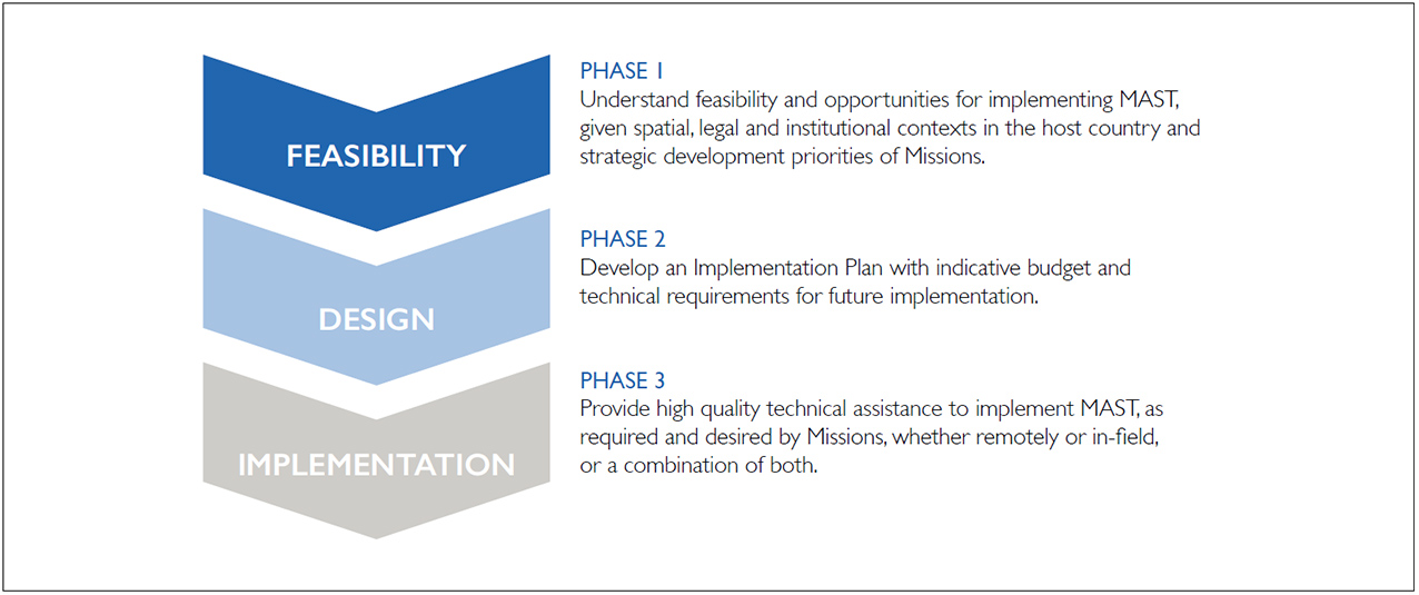
Through its commitment to addressing extreme poverty, USAID is integrating a deeper understanding of the role marine tenure and small-scale fisheries play in supporting biodiversity conservation, food security, inclusive economic growth, and other priority development objectives. Maintaining healthy and resilient marine and coastal ecosystems provides the natural capital to support USAID’s objective to conserve biodiversity for sustainable, resilient development. Insecure resource tenure rights to fisheries can be one of the most significant drivers of biodiversity loss and unsustainable natural resource management. Where rights are poorly defined, marine and freshwater ecosystems can be quickly degraded, leading to overfishing. Securing resource tenure for fishers can set the stage for reducing pressures to biodiversity, creating sustainable livelihoods, enhancing food and nutrition security, building resilience, and reducing competition over limited resources. The USAID/E3 Office of Land and Urban’s Tenure and Global Climate Change Program has developed a sourcebook and guidance designed to assist USAID staff and partners integrate consideration of sustainable small-scale fisheries and the responsible governance of marine tenure in programming and project design. As part of this guidance, USAID is developed and tested a country-level assessment tool to promote awareness and implementation of the Voluntary Guidelines on Securing Sustainable Small-scale Fisheries in the Context of Food Security and Poverty Alleviation (SSF Guidelines) (FAO, 2015). This information brief provides an overview of the development and testing of the Tool.
BACKGROUND
The SSF Guidelines (http://www.fao.org/fishery/topic/18240/en) are the first dedicated international instrument to directly address the sustainability of the livelihood approaches of small-scale fishers, fish workers, and their families. They provide guidance on how to support the visibility, recognition, and enhancement of this globally important element of the fisheries sector and are aimed at engaging a range of key agents of change including small-scale fishery actors (fishers, fish workers, communities, traditional and customary authorities), governments, regional, international, and intergovernmental organizations, related professional and civil society organizations, research and academic institutions, and the private sector. The SSF Guidelines are voluntary, focus on the needs of developing countries, promote a human rights approach, and encompass all activities along the fisheries value chain, including pre-harvest, harvest, and post-harvest. The SSF Guidelines were endorsed by Thirtieth Session of the Fisheries and Agriculture Organization (FAO) Committee on Fisheries following a global process that involved representatives of governments, small-scale fishers, fish workers and their organizations, researchers, development partners, and other relevant stakeholders from more than 120 countries. This process drew attention to the considerable contribution of small-scale fisheries to meeting development objectives.
THE ASSESSMENT TOOL
PURPOSE. The SSF Guidelines detail a rich, multisectoral compilation of good practices for a wide range of stakeholders to be aware of and to adopt to secure sustainable small-scale fisheries for food security and poverty eradication. As such the Tool is designed to raise awareness of these good practices and to support a country-level assessment of status of implementation to inform programming and project design. The output of this assessment will highlight strengths and gaps in a country’s national legal and policy framework for supporting responsible governance of marine tenure as well as the larger policy goal of sustainable small-scale fisheries. Gaps in the national legal and policy framework highlighted by the assessment can inform the description of a country’s development context and point the way toward strategic policy reforms. Further, the assessment will serve to highlight examples of local implementation successes that can inform the development of strategic approaches in project design and implementation.
TOOL STRUCTURE. The Tool is structured as an assessment matrix organizing the SSF Guidelines under eight themes and 20 strategic actions. Each strategic action is associated with three to four good practices based on the SSF Guidelines. Two cross-cutting themes in the SSF Guidelines, capacity development and implementation support and monitoring, were incorporated across the eight themes.
ASSESSMENT AND RATING PROCESS. The assessment process begins with a desk review of the status of implementation of the good practices by theme. In the desk review, the provisions of relevant national laws and policies are summarized for each theme. The second part of the desk review is to identify examples of programs and projects that support local implementation of the good practices for each theme. The information compiled in the desk review is then enhanced through focus group meetings and key informant interviews to develop a provisional assessment. Through this process, the provisional assessment provides an initial response to two key questions:
- What are strengths and gaps in the national and subnational enabling conditions for implementation of the good practices by theme?
- What are strengths and gaps in local implementation of the good practices as evidenced by programs and projects by theme?
The provisional assessment is used as input to a multisectoral workshop. The multisectoral workshop is designed to bring together relevant stakeholders and expertise to review and refine the provisional assessment, develop the ratings, and identify policy reform and programming opportunities. Workshop participants are broken out by theme to discuss strengths and gaps and assign ratings.
The implementation status is ranked individually for each question as high, medium, low and then a cumulative rating can be made by considering the status of both national enabling conditions and local implementation. The output of the workshop is expected to: (a) validate/refine the provisional assessment; (b) bring broader consensus to the status of implementation of the SSF Guidelines; and (c) identify opportunities for policy reform and programming.
TOOL TESTING
A provisional country-level assessment using the Tool was conducted in the Philippines and Indonesia. A desk review was conducted to summarize relevant background information needed to conduct the assessment. Focus group discussions with USAID staff and partners were conducted to review the background information and provisionally assign ratings. The usefulness of the tool was acknowledged. Productive discussions on the meaning of the guidelines were generated which helped participants understand the complex and multisectoral nature of addressing small-scale fisheries. Due to the limited nature of the assessment, information gaps were encountered for specific themes such as social development, employment, decent work and value chains, post-harvest, and trade. A multisectoral workshop would be needed to raise awareness of a broader range of stakeholders and to deepen and refine the assessment results.
Some refinements to the Tool were identified during testing which were incorporated. It was recommended that guidance be developed on how to use the assessment results to develop a multi-sectoral strategy to strengthen implementation of the SSF Guidelines toward securing sustainable small-scale fisheries.
NEXT STEPS
The USAID/E3 Land Office’s Tenure and Global Climate Change program has completed a guidance document (Primer) and an in-depth compendium of knowledge (Sourcebook) on marine tenure in small-scale fisheries. The primer, “Looking to the Sea to Support Development Objectives: A Primer for USAID Staff and Partners”, provides a series of job aids and considerations that are designed to guide USAID staff and partners on the integration of responsible governance of marine tenure into USAID programming. The Assessment Tool is included in the Primer. The sourcebook, “Marine Tenure and Small-scale Fisheries: A Sourcebook of Good Practices and Emerging Themes”, provides a deeper look into emerging themes and practices in small-scale fisheries and marine tenure by drawing on findings from scholarly research, policy documents, and development projects by donor agencies and leading nongovernmental organizations. Both outputs were informed by lessons learned from field assessments conducted in Bangladesh, Indonesia, and the Philippines. All documents are available at
https://www.land-links.org/issue/marine-tenure/.
CONTACT
CONTRACTING OFFICER’S REPRESENTATIVE
Stephen Brooks
Email: sbrooks@usaid.gov