MAST blends participatory mapping approaches with flexible technology tools to help local communities who lack access to government services to document, manage and secure their land and resource rights.
The Challenge
More than 1 billion people around the world lack secure rights to their land, their homes, and the resources they depend on for their livelihoods.
Learn MoreWhat MAST Offers
Over the last decade, USAID has supported communities in Burkina Faso, Ghana, Liberia, Malawi, Mozambique, Tanzania, and Zambia to use MAST.
Learn MoreWho Uses MAST and Why?
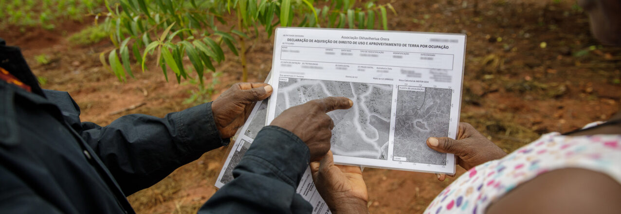
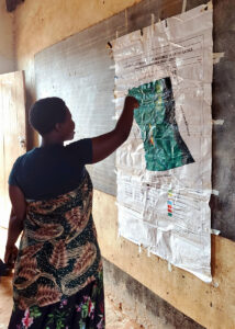
To date, MAST has typically been used by local organizations and communities to collaboratively map and document property boundaries, and collect information about landholders.
Learn MoreBenefits of MAST
Evidence from a decade of research and implementation shows that in addition to being transparent, flexible, and inclusive, the MAST approach allows communities to map and document rights more quickly and for less money than traditional approaches.
Learn More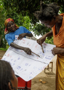 The Challenge
More than 1 billion people around the world lack secure rights to their land, their homes, and the resources they depend on for their livelihoods. This land tenure insecurity, particularly among low-income households and women, remains at the core of the world’s most pressing development challenges, and contributes to conflict, gender-based violence, hunger, poverty, deforestation, and vulnerability to disaster.
A key driver of land tenure insecurity is that households often lack documents to prove their land and property rights. It is estimated that nearly three-fourths of all land parcels globally are not documented. Women, youth, Indigenous Peoples and other vulnerable groups are more likely to lack documentation of their land and property rights.
Low rates of land and property documentation are driven by a host of factors, including lack of government capacity or lack of willingness to map and title large areas of a country; high costs and slow, bureaucratic process for obtaining land documents; and discriminatory laws and social norms that might discourage certain members of a community from seeking these documents.
 What MAST Offers
MAST is a participatory mapping approach that solves this challenge by:
(1) Identifying gaps in government-provided land services;
(2) Helping community members understand the requirements and opportunities for filling these service delivery gaps by mapping, verifying, and documenting their land and resources in an efficient, sustainable, and inclusive manner using mobile devices; and
(3) Empowering local communities and organizations as data collectors and verifiers, building their capacity to identify and deploy the right mix of technologies, tools, and methodologies to efficiently and affordably document their rights and to manage land information.
Over the last decade, USAID has supported communities in Burkina Faso, Ghana, Liberia, Malawi, Mozambique, Tanzania, and Zambia to use MAST in order to map hundreds of thousands of land parcels, helping thousands of people obtain more secure rights to the land they live and depend on. MAST has been rigorously tested, and a substantial and growing body of evidence shows that this flexible, participatory approach supports improved land tenure security in service of multiple other development objectives ranging from women’s empowerment and food security to climate change mitigation and biodiversity conservation.
Who Uses MAST and Why?
To date, MAST has typically been used by local organizations and communities to collaboratively map and document property boundaries, and collect information about landholders. This information is then used for a variety of purposes, including issuing formal land documentation (via a government certificate), or informal land documentation (via a shared understanding with the local community).
Because MAST involves the use of digital mapping tools that are not often accessible by local communities, local NGOs or local governments often provide communities with assistance and tools to implement the MAST process.
MAST users seek to document their land and resource rights for a variety of reasons, including:

Reducing property disputes

Improving access to finance

Assisting with conservation activities
Ensuring property can pass to heirs

Protecting the claims of women and other marginalized community members

De-risking long-term investments made on their land
Benefits of MAST
Evidence from a decade of research and implementation shows that in addition to being transparent, flexible, and inclusive, the MAST approach allows communities to map and document rights more quickly and for less money than traditional approaches. Specifically: