“In the municipalities supported by USAID we can deliver more titles and achieve goals faster”

Q&A with María José Muñoz, Land Formalization Expert from Colombia’s Property Registry (SNR)

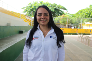
Since 2016, Colombia’s property registry authority, the Superintendence of Notaries and Registers (SNR) has worked with Municipal Land Offices (MLOs) to register and deliver thousands of land titles to owners all over the country. In this interview with María José Muñoz, Delegated Superintendent for the Protection, Restitution and Formalization of Land of the SNR, she talks about the importance of promoting land titling, how MLOs facilitate coordination with state entities and USAID’s role to support the process.


What does a Delegated Superintendent do and how do you coordinate work with Municipal Land Offices?

The Delegated Superintendent for the Protection, Restitution, and Formalization focuses on strengthening and supporting territorial entities with property and land formalization processes in the urban areas of a municipality. We are distributed across five regions where the SNR is providing legal and technical support to territorial entities with the administrative act of user ownership. As a delegate, what I do is coordinate work between the territorial entities and SNR’s regional property registry offices around the registration of an administrative act, which is how an urban property is delivered to the citizens of a municipality.

What objectives and challenges do you have in the SNR?

The main objective is to have more Colombian landowners every day, and this is achieved through the support of territorial entities or territorial authorities that have signed agreements with us. This has been a challenge, which is why we try to impact more territorial entities, more municipal and departmental administrations, so that they can sign agreements with us and we can support them in that objective of making more Colombians landowners.

Does USAID’s coordination make the process faster? 

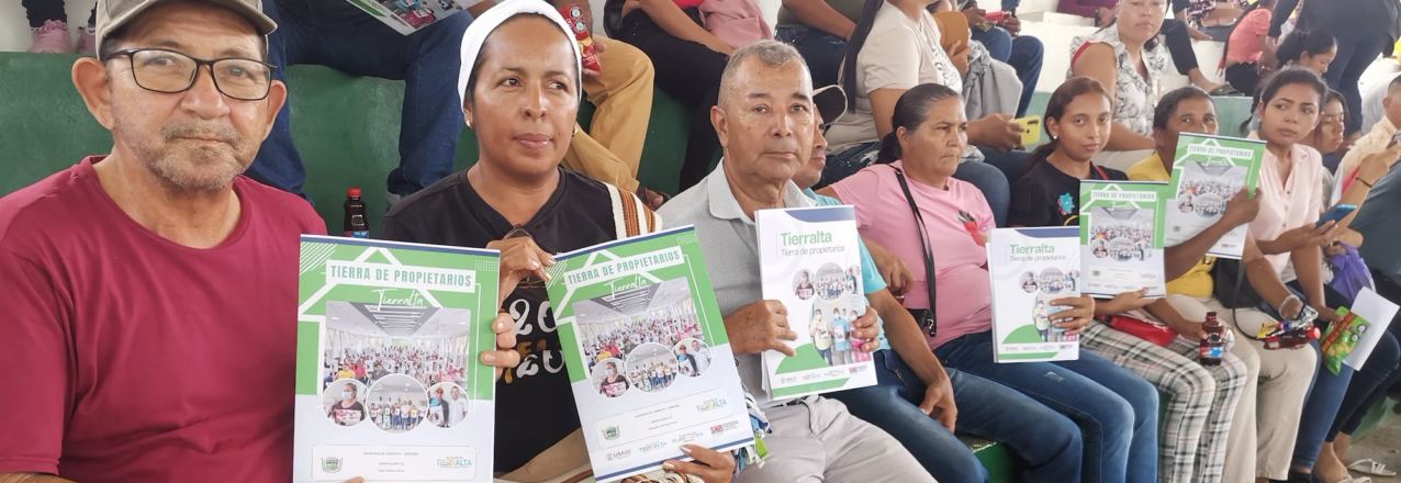
USAID’s coordination is extremely important. As a third party, USAID supports the MLOs and the SNR. It is easier when we can count on the contribution of physical and institutional resources of an entity such as USAID, compared to when it is done directly between the territorial entity and the municipal administration. In the municipalities that have USAID support we can deliver a lot more land titles and the goals are achieved in a faster and more comprehensive way. A clear example of this is here in Tierralta where we have delivered more than 1,950 land titles since 2017.

In July 2023, Tierralta delivered 261 land titles. Why was that significant?

Of the 261 urban land titles, 179 were delivered to women. This means that almost 70% of the titles benefit women, and this is extremely valuable because historically, property in Colombia has benefited mostly men. In Tierralta, where the first pact was signed with the United Self-Defense Forces of Colombia (AUC) for the surrender of weapons and where historically there has been so much violence, the most vulnerable have always been women and children.

What does it mean for a woman to be a landowner?

It means that they are the legal owners of their homes. When a woman is the legal landowner, and the title is registered with the Registry Office, it gives her access to government programs and subsidies, for example for home improvements, also to a mortgage if she needs it, and her children can inherit the property for future generations. And of course, she is making sure that her children have a home which is protected by the government.

How do Municipal Land Offices facilitate the work of the SNR?

They facilitate coordination, because it is very difficult to reach certain regions from the central level. I repeat, Tierralta is a great example because there is a Property Registration office close by in Montería, and this makes it easier for the staff of the MLO to coordinate with the SNR. Issuing an administrative act for the ownership of a property requires a lot of previous steps, including on-the-ground verification and the certification of historical titles that the municipal administration may or may not have. So it is very important that these teams are in the regions, because this could not be done from an office in Bogotá. This also increases the hiring of local employees, since they are the ones who know their region.

USAID has supported the SNR with the digitization of property registration files, how does this contribute to the efficiency of the SNR today?

There was a lot of money invested, but we are still missing a significant amount of files. I recently spoke with some registrars who benefitted from USAID’s Land for Prosperity Activity in Santander de Quilichao and Puerto Tejada in Cauca, and they mentioned the advantage of having the files not only digitized but also indexed. This allows them to search within a PDF file and not have to be exposed to a dusty physical file where they don’t know if they will find what they’re looking for.

Cross-posted from USAID Exposure

Peace through Honey

A public-private partnership, facilitated by USAID, is increasing the economic and environmental benefits for beekeepers in the Montes de María.

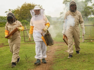
In the Montes de María, a sub-region of the Colombian Caribbean region characterized by the abundance of its tropical dry forest, great stories of resilience have been consolidated thanks to the art of beekeeping.

One of these stories arises thanks to the honest work that for more than 50 years Tomasa, la de la miel, as Tomasa Elena Calonge Ortiz, legal representative of La Casa de la Miel, a company that markets real honey and beehive products, has been able to win the hearts of the inhabitants of the territory and, above all, safeguard the ancestral knowledge about the management of traditional beekeeping.

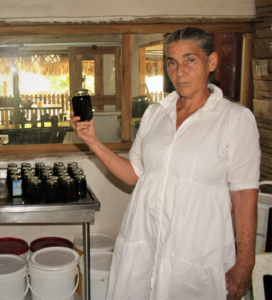
Everybody who has tasted it, says Tomasa’s honey is unparalleled. Tomasa Calonge partners with only the hardest working bees, and she does not add sugar, which is critical to producing pure honey and a guarantee to appeal to the palates of those who recognize quality. 

Tomasa is from a family of beekeepers who arrived in El Carmen de Bolívar nearly 30 years ago. She and the industrious bees have built the company La Casa de la Miel, located in the Montes de María region of northern Colombia.

“I arrived empty-handed, but I brought my heart and the knowledge of an ancestral art that can only be transmitted with love,” says Tomasa Calonge.

Increasing deforestation and the use of pesticides in industrialized agriculture threaten the trade. But Tomasa continues working with her local community to share her knowledge and skills in beekeeping and create a market for excellent honey.

“Our work honors the tropical dry forest which makes Montes de María unique, but beekeeping is not an easy path these days,” she says.

A Partnership for Honey

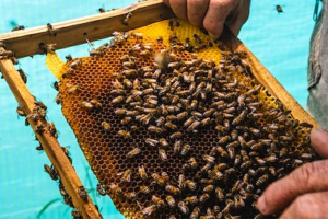
A public private partnership (PPP) in the honey value chain facilitated by Land for Prosperity will give Tomasa and over 680 beekeepers in the Montes de María region the chance to offer quality honey products to people across Colombia. The PPP, valued at more than US $1.1 M, is netting investments from a wide range of public institutions and supports 22 beekeeper associations.

The PPP is instrumental in the creation of the region’s first Honey and Beekeeping Committee, a body of like-minded farmers, processors, and traders who can work together in economies of scale to achieve commercial success. At the producer level, the PPP aims to strengthen business plans and consolidate direct sales with commercial partners like La Casa de Miel and Apiarios de la Sabana. The PPP will also help beekeepers with the process of achieving health and sanitary authorizations and a denomination of origin for honey produced in Montes de Maria.

“With USAID support, we hope this partnership will help us to promote our honey and make its quality known. Honey that is fresh and wisely extracted by our bees from the forests of Montes de María,” explains Tomasa Calonge.

Land for Prosperity seeks to expand licit economic opportunities by mobilizing public and private funds for local public goods and services and encourage private sector participation in value chain partnerships.

Since 2020, Land for Prosperity has facilitated 25 public-private partnerships in key value chains like coffee, cacao, and honey, as well as other cash crops like limesesame, and papaya. The partnerships have already mobilized over USD $92M in funds to build local capacity to plan for and execute public resources, improve marketing and establish new commercial agreements, and promote inclusion and empowerment among women and youth.

Cross-posted from USAID Exposure

Finding Common Ground

LFP supports a network of youth leaders and their relationships with the private and public sector to increase synergy around water conservation.

Since the 2021 social protests, young people in Colombia and especially in Cauca have increased their distrust and distanced themselves from state institutions. However, interfacing with the public sector and large scale agro firms like Riopaila Castilla gives youth social leaders the chance to dialogue and find common ground, in this case, the protection of critical watersheds in the region.

The Youth Water Protectors Network, known as the Red de Jóvenes Sembradores del Agua, has completed its first cycle under the Conservation public-private partnership (PPP) in Northern Cauca, reaching 30 youth, indigenous and Afro-Colombian social leaders, students, and farmers from Corinto, Toribio, Caloto, Miranda, and Santander de Quilichao. They are brought together by their passion for environmental issues in their region.

The diverse group of youth leaders have already participated in five workshops and conducted field visits to conservation areas such as the Munchique National Park. The youth network also coordinated visits and roundtable discussions with Cauca’s Environmental Authority (CRC) and the Fundación Caicedo González, the corporate social responsibility arm of Cali-based agro-industrial giant Riopaila Castilla.

“This youth network has given us the opportunity to be the voices of our communities in regards to state entities and be proactive with our new ideas, which are formed by how we live and see the world from our municipalities,” says Irania Díaz Escudero, social leader from Corinto.

The municipality of Corinto is located on western flanks of the Colombia’s central mountain range in the foothills of the massive Nevado del Huila volcano. Its main river, La Paila, feeds the larger Palo River system and is home to fragile ecosystems and native forests, which are threatened by expanding agro industries and illicit crops. Corinto’s flat areas are covered by sugar cane plantations that use highland water and place watersheds at risk due to sewage and wastewater from sugar mills.

Creating Dialogue

The youth network met with researchers from Cenicaña, a Cauca-based sugarcane investigation organization and with representatives from Riopaila Castilla. The visits allowed the youth leaders to learn more about sugarcane processing, Cenicaña-led environmental initiatives, and water management in industrial sugar plants.

This collaborative scenario has potential for positive outcomes. The Fundación Caicedo González would consider financing environmental projects led by the youth network in their municipalities. The youth group will come up with ideas for water conservation projects that also mobilize youth, and LFP will help structure the proposals.

“For the private sector, it is important to support this type of initiatives because we transform our territory by coming together and because environmental issues affect all of us,” explains Daniella Tafurt, environmental territorial development agent from the Fundación Caicedo González

Partnership for Water

The PPP in conservation was facilitated by Land for Prosperity in 2022 to promote cooperation among communities and the public and private sectors to protect key ecosystems and water resources in Northern Cauca. The PPP includes contributions amounting to USD $2 million and has held four large-scale forums on conservation, waste management, and watershed protection.

Under similar activities, the PPP also trained a group of women under the Escuela de Mujeres Cuidadoras del Agua, an initiative aimed at women leaders. The innovative school included eight training sessions totaling 60 hours of training in gender and equality as well as their intersection with environmental topics like: climate change, water resources, payment for ecosystem services, and sustainable agriculture practices.

The women water protectors belong to Afro-Colombian communities, indigenous groups, local governments, youth organizations, agriculture associations, and environmental NGOs from the municipalities of Santander de Quilichao, Caldono, Guachené, Corinto, Toribio, and Suárez

USAID and NASA Support Bangladesh Land Planning for Food Security and Sustainable Development

Read the full-length op-ed published in GIS Resources magazine. This version has been edited for length and clarity.

Bangladesh is a land-scarce country with a high-density population. As the majority of the population still lives in rural areas and depends on agricultural activities for their food and livelihoods, proper rural land management is critical to their well-being. However, land use changes and the impacts of climate change are rapidly reducing the amount of arable land, which has major implications for food production. Bangladesh requires an increased investment in sustainable land use planning to both increase economic growth and ensure food security for its growing population.

Since 2019, SERVIR Hindu Kush Himalaya, a joint project of NASA and USAID  implemented by the International Centre for Integrated Mountain Development (ICIMOD), has provided technical support to Bangladesh to develop and use a national land cover monitoring system to track land cover changes across the country. The land cover monitoring system uses open-source satellite imagery to generate land cover maps annually. Bangladesh uses the land cover maps to monitor forest inventory and plans to expand to using them to strengthen sustainable rural land use planning.

Changing Rural Landscapes

In villages across Bangladesh, human populations are expanding, creating greater demand for housing. To meet this demand, houses are now being built on fertile agricultural land, a limited resource. Restoring agricultural land or forest land is extremely difficult after it has been converted to other uses like housing.

Haphazard planning of rural dwellings negatively affects Bangladesh’s village ecosystems. Houses built on floodplains or canal banks cause stream bank erosion, flooding, and obstruction of water flow. Because village infrastructure cannot handle heavy rains, water accumulation causes flooding. The densely built areas also disrupt natural habitats and contribute to air and noise pollution. These risks are compounded by the impacts of climate change–Bangladesh is the seventh most affected country in the world by extreme weather events.

Detailed spatial land-use planning is critical to counter threats from changes in rural land use. Spatial land-use planning is a collective effort to develop and approve land-based activities. It provides a basis for the creation of zoning laws and defines specific uses of land that balance economic priorities with protecting the natural environment, strengthening living conditions, conserving natural resources, and  promoting social cohesion. It requires up-to-date information on how land has changed over time, such as from forest to agriculture or agriculture to urban.

How Geospatial Technologies Help

Geospatial information is a critical component of land use planning and sustainable natural resource management. Geographic information systems (GIS) integrate diverse Earth observation imagery, spatial data (including land cover maps), and information on how human activities have historically affected and currently affect land use over time. GIS also makes it possible to project how anthropogenic environmental changes may affect land use and land cover in the future. It can be used to develop suitability maps for agricultural and infrastructure development by analyzing factors such as soil type, slope, water availability, and existing infrastructure.

Land use mapping and spatial planning allow decision makers to  assess complex alternative development scenarios and model possible future changes, providing a basis for making informed, evidence-based decisions for rural land use.

Aerial views of Pirojpur villlage in 2003 and 2021 for the purpose of comparing expansion of human activity.
Satellite images show how human activities have expanded in Pirojpur village since 2003. Credit: GIS Resources

As one of the world’s most flood-prone countries, Bangladesh also needs flood risk and flood shelter suitability maps for different climate change scenarios. Geospatial data provide decision makers the information they need to choose building sites that do not encroach on productive land, are not at risk of being submerged in floodwaters, and are reachable by human populations.

Appropriate and effective land use planning, implementation, and management can ensure rural development that is sustainable, environmentally sound, and strengthens food security. SERVIR is committed to ongoing collaboration with partners in Bangladesh to achieve these goals.

This blog was originally published on Climatelinks

A Community Willing to Exchange Illicit Crops for Land Titles

USAID is helping farming families title their land and access licit economic opportunities in exchange for eradicating their coca crops.

When Víctor Ruíz heard that a massive land formalization initiative was coming to Cáceres, his municipality in Antioquia, he never imagined the impact it would have on his community. Throughout his life, Ruíz has grown coca, the main ingredient in cocaine. His family farm extends over 79 hectares, and they usually reserve three hectares for these illegal, yet lucrative crops.

But now Víctor, president of the Los Lloros community action board, will no longer grow coca. When he has his registered land title, he understands there is a range of opportunities that could benefit his family, his community, and his region.

“The most important thing for landowners is to have our land titled,” says Ruíz. “If we don’t have land titles, we can’t access state resources. We know that a plot of land that does not have its documents up to date is not going to obtain benefits.”

The Rural Property and Land Administration method was designed by USAID with contributions from the National Land Agency

A Disconnected Past

The lack of a legal connection to their property facilitates the decision to plant illicit crops, says Ruíz. When combined with the municipality’s history of violence and the lack of goods and services provided by the state, informal land markets aggravate the economic situation of thousands of farmers who feel there are no viable options to access competitive markets and improve their lives. As a result, growing coca plants is less a crime and more a sensible choice for survival. It’s a vicious circle in which the two elements of an absent government and illicit trade have inexorably led to a worsening of the security situation.

Currently in Cáceres, there are more than 600 families involved in growing illicit crops on more than 1,400 hectares, according to a study derived from the latest aerial photographs taken for updating the rural cadaster and titling properties. The current levels show that the number of hectares planted with illicit crops grew by 16 percent during the pandemic years 2020-2022, according to figures from the United Nations-funded Integrated Illicit Crop Monitoring System (SIMCI).

The formalization initiative, known as the Rural Property and Land Administration Plan (POSPR by its Spanish acronym), compiles parcel information, land use data, and strives to resolve land conflicts among neighbors. This makes it possible to update the rural cadaster, deliver property titles to landowners, and support a functioning land market, all of which contribute to the 2016 Peace Accords.

“It is no secret to anyone that, nationwide, not just here in Bajo Cauca, there is a lot of illicit cultivation,” says Ruíz. “If that plot or farm has these crops, it is logical that they will not be legalized until they are eradicated.”

original (5)

For Colombia’s National Land Agency, the Cáceres parcel sweep has made it clear just how difficult it is for some communities to go from one village to the next. Parcel sweep operators visited every parcel in the municipality, exposing the needs of locals to access legal markets with their products.

Cáceres, Center of Transformation

The Government of Colombia has selected Cáceres as the first municipality to implement the 3T Strategy, which seeks the voluntary substitution of illicit crops in exchange for the formalization of property. The three T’s stand for Titling, Transition and Transformation, and the strategy is novel because it leverages USAID’s ongoing support for land tenure programming in partnership with the Ministry of Justice and the United Nations Office on Drugs and Crime (UNODC) for compliance.

In addition to the titling of rural property, the 3T Strategy includes a plan to support food security for rural families, investments in small infrastructure projects, and funds to plan and improve agricultural projects in key value chains like cocoa, honey and dairy.

Like the family of Víctor Ruíz, more than 450 households in rural villages in Cáceres could potentially opt for land titling and support from the government over growing illicit crops. So far, over 100 families have confirmed their participation in the 3T Strategy.

“The massive property sweep is transforming lives and territory,” says Ruíz.Once the 3T Strategy has been tested in Cáceres, the government aims to replicate it in four municipalities which, together with Cáceres, concentrate 13 percent of Colombia’s coca, according to SIMCI: Puerto Rico (Meta), Santander de Quilichao (Cauca), Sardinata (Norte de Santander) and Tumaco (Nariño).

The 3T Strategy’s innovative feature is the combination of property titling, state interventions, and support from development aid with a previously invisible ingredient: the decision-making power of the communities who choose a culture of formal land ownership and responsible economic development in their villages over the short-term benefits of illicit crops.

Reaching communities with these services depends on the leadership of people like Víctor Ruíz. As president of the community action board, Ruíz was involved in the parcel sweep as a community manager. His role is to motivate local residents to voluntarily eradicate coca crops. His participation is fundamental to making them see why obtaining a registered land title is what they have dreamed of for years.

The land titling component of the 3T Strategy has already begun delivering land titles to rural families in Cáceres and will continue throughout 2023.

Like Víctor, there are 20 social leaders who worked in the massive property sweep as community managers in Cáceres. Edid Medina is a community manager and president of the community action board in the village of Vijagual. She also encourages her community to voluntarily eradicate coca and plant other crops such as cassava and corn on their land. For her, having a title deed to her land represents hope and is the document that supports her when she needs to acquire a loan or apply for a subsidy to improve her home.

“After uprooting the coca, what we have is a grass pasture. Right now, we are planting corn, rice and cassava. I have the hope that you can go to any bank, anywhere, and with a land title, you don’t come empty-handed, you come with hope,” she says.

A Voluntary Choice

In 2023, following the finalization of the land sweep and the validation of over 11,500 parcels, the National Land Agency began holding public hearings, which is a final step before land titles are emitted. In the first public hearing, where more than 150 people attended, and17 families that grow illicit crops signed agreements for voluntary eradication.

original (8)

In Cáceres, POSPR implementation identified 1,263 parcels covering 58,600 hectares that are subject to agrarian reform processes, and 1,024 applications for access to land by landless families.

Women’s Land Rights Champion: Serge Ramanantsoa

This interview with Serge Ramanantsoa, USAID/Madagascar, is part of USAID’s Land and Resource Governance Division’s Women’s Land Rights Champions series, which profiles staff across USAID Missions and operating units who are working to advance women’s land rights.

Tell us about yourself

Serge Ramanantsoa headshot
Serge Ramanantsoa, USAID/Madagascar

My name is Ramanantsoa Serge and I hold several roles in the Sustainable Environment and Economic Development (SEED) office: Project Management Specialist / Climate Integration Lead for USAID/Madagascar, the point of contact for the Mission regarding land issues, and activity manager for the Integrated Land and Resource Governance (ILRG) activity in Madagascar. Our USAID SEED office is responsible for all programs related to the preservation and protection of biodiversity, sustainable landscapes, climate change, and the fight against wildlife trafficking while also improving the living conditions of local communities through cooperation with the private sector. In my former work at UN Habitat Madagascar, I investigated land tenure and land planning for slums located around large and medium cities in Madagascar. This experience allowed me to share my knowledge with the ILRG activity to carry out analyses on the complexity of land and resource governance in Madagascar, and then develop a roadmap for land tenure considering women’s access to land and the preservation of watersheds and forests.

Why are women’s land rights and resource governance important to your work? And to other USAID development work?

Women’s land rights and resource governance are important to our work in the Sambirano Valley of Madagascar, and to USAID, because women occupy important roles in the Malagasy community– specifically related to the collection of wood for energy, collection of water, and providing education for children. Yet, women’s access to land and leadership positions are limited by culture and customs in addition to their rights to crucial resources and access to income-generating activities needed to meet their families’ daily needs. This is especially true in the case of single mothers. 

One way we work to counter this issue is by ensuring ample participation by women in our development activities and ensuring that there is equal representation of women to men within the target communities that we reach. We also work to build the participation of women in leadership boards of the communities and organizations that we work with, and increase the rates of women’s land ownership. 

What are some of the biggest challenges in helping women secure land rights and what are some things being done to overcome them?

The biggest challenges are the exclusionary customs that make it difficult for women to inherit land, and high rates of illiteracy.

To overcome the challenges, USAID/Madagascar conducts educational awareness campaigns on land rights, which has been customized to address the needs of those who are illiterate, to change existing customs and exclusionary mentalities. In addition, we are working on systematic integration of women into local community organizations so they can advance in land acquisition procedures. These activities, as well as others, are reported on the GNDR-2 (Gender Equality/Female Empowerment) indicator, which details the percentage of female participants in U.S. government-assisted programs for the sake of increasing access to productive economic resources (assets, credit, income or employment).

What are some of USAID’s successes in the area of women’s land rights?

Some specific successes so far have been the constitution and promotion of Women Land Leaders (WLL), then the integration of WLL in the consultation, advocacy and decision-making platform (FIVEDISAB “Sambirano Women’s Association”) on land issues in the Sambirano Valley.

FIVEDISAB has developed a plan for monitoring and strengthening its structure and has received support for insertion in the national networking platform with the SIF (national platform of civil society working in land).

There has also been support for the updating and official regularization of administrative documents which improve access to resources (especially land) for women.

Returning the Land they Own

The Municipality of Santander de Quilichao is delivering land titles and improving compliance with land restitution rulings

In the early 2000’s, the small town of Lomitas, located in southern Colombia, was the epicenter of several years of paramilitary operations. The violence took the lives of many and displaced hundreds more. When residents returned to their lands, their crops were destroyed and their animals were gone. What’s worse, their properties were in the hands of several sugarcane companies.

Orfanis Sandoval returned to Lomitas in 2008 to find her house had been destroyed. Sandoval’s land was first owned by her grandfather more than 60 years ago. Her father inherited the land, and she and her siblings inherited it from her father.

“Before my father died, my siblings and I decided who would get what pedacito (piece) of land. We worked hard and built what we could,” explains Sandoval.

In 2012, with the support of Colombia’s Land Restitution Unit, the Sandovals and the people of Lomitas began a multi-year legal battle to recover their land and seek compensation for their suffering. Over the years, restitution judges have issued several rulings in their favor, including orders for reparation measures that benefit the entire community. More than 20 restitution rulings have come down in favor of the town, including one that requires the Government of Colombia to title their property.

Orfanis Sandoval (right) and her neighbor, live in Lomitas.

The Guarantees of a Land Title

The titling of the victims’ property is an essential part of land restitution rulings and provides people with a guarantee that their property cannot be stolen from them again. In 2023, Orfanis Sandoval and some of her neighbors received the land titles that were promised to them under the restitution rulings. The land titles, which were delivered more than five years after the initial ruling, may have taken longer if it weren’t for the efforts of the Municipal Land Office.

The municipality of Santander de Quilichao is the main city in the mountains of northern Cauca, approximately 80 kilometers south of Cali. The Municipal Land Office was created in 2017 with USAID support and plays a prominent role in land administration as liaison with Colombia’s National Land Agency as well as with the victims of Lomitas.

Equipped with the capacity to quickly survey a property or research the history of a property deed, the land office team overcomes the typical challenges associated with land administration in Colombia, and they do it from the Municipal building.

The Santander de Quilichao Municipal Land Office has delivered over 600 land titles and mobilized nearly US $15 M in public funding for infrastructure and city improvements thanks to secure land tenure.


“The mere presence of the Land Office is important. We are the social workers who reach out and coordinate with victims in Lomitas, and we provide assistance to the National Land Agency when they come to make technical visits to the parcels being titled,” explains Bernardo Pinzón, a social worker in Santander de Quilichao’s Municipal Land Office.

Over the last decade, USAID has invested resources and expertise to strengthen Santander de Quilichao’s capacity to respond to land restitution rulings. USAID helped create a localized Land Restitution Subcommittee, which supports compliance with restitution rulings. Thanks to the land administration experts embedded in the administration, the municipality has developed and implemented a portion of the collective and individual measures contained in the ruling, proving to be crucial for the community.

The Municipal Land Office has formalized community spaces such as the soccer field, and the municipality built a children’s playground. USAID and the municipality have also organized service fairs in the community, where health entities offered vaccinations to children and adults, dentists provided check-ups, and banks offered financial products.

“Knowing that the public spaces of Lomitas have been legalized by the Municipality gives us the chance to enjoy them without worrying about landowners showing up to claim they own the land,” explains Orfanis Sandoval. “We have more confidence to hold community events.”

Santander de Quilichao's Municipal Land Office Team

“Now we are the owners of the property, and they can’t take that right away. Now we can plant our gardens without fear. We can have chickens. We can invest in ourselves and not feel like we could lose it all again.

Our community feels that the Municipality has been aware of our issues. And we hope that more residents will get the same opportunity.”

-Orfanis Sandoval, Community Leader in Lomitas, Santander de Quilichao

2023 Climatelinks Photo Contest: July 11, 2023 – August 7, 2023

The Climatelinks 2023 Photo Contest theme is USAID’s Climate Strategy in Action: Confronting the Climate Crisis Across Sectors. Climatelinks is looking for submissions that show the breadth of issues, impacts, and solutions to climate change across 13 categories. Submissions will be open starting July 11, 2023.

The main categories are listed in bold below. Examples of submissions under each category are also noted. For images containing any identifiable individual, a release form will be requested upon submission.

Agriculture and Food Systems 

  • Climate-Resilient Agriculture
  • Food Security

Biodiversity Conservation

  • Wildlife
  • Landscape/seascape conservation
  • Community engagement
  • Fisheries
  • Ecosystem-based Adaptation
  • Natural Resource Management

Democracy, Rights & Governance

  • Corruption
  • Governance/Civil Society
  • Human Rights
  • Environmental Defenders
  • Climate Justice

Humanitarian Assistance (Currently DRM)

  • Conflict
  • Migration
  • Disaster Risk Management
  • Loss and Damage

Education

  • Learning Outcomes
  • Education Infrastructure
  • Monitoring, Evaluation, and Learning (MEL)

Energy

  • Renewable Energy
  • Microgrids
  • Energy Efficiency
  • Data/Technology/Innovation

Climate Finance and Economic Growth

  • Circular Economy
  • Private Sector Engagement
  • Livelihoods

Green Cities

  • Resilient, Low-carbon Infrastructure
  • Ocean Plastics
  • Urban

Health

  • Air Quality
  • Heat
  • Nutrition
  • One Health

Natural Climate Solutions

  • Forest Conservation
  • Ecosystem Restoration
  • Nature-based Solutions
  • Mangrove Restoration
  • Forests and Livelihoods

Water and Sanitation

  • Water Management
  • Infrastructure
  • Gray water

Gender, Equity, & Social Inclusion

  • Indigenous Peoples and Local Communities
  • Locally-led Development
  • Gender and Social Inclusion
  • Diversity, Equity, Inclusion, and Accessibility (DEIA)
  • Children, Youth
  • Self-determined Development
  • Locally-led Climate Action

**Photo submissions captured from June 2022 until July 2023 will be accepted.**

You may submit up to five images complying with the contest rules and requirements. Entries will be judged on relevance, composition, originality, and technical quality. Winners will be selected overall through an evaluation panel composed of USAID staff and the Climatelinks team.

The contest runs until August 7, 2023. Winning photos will be announced in Fall 2023, subsequently featured in Climatelinks communications, highlighted on the website’s topic pages, and showcased in the Climatelinks photo gallery.

A Future of Forests

USAID is providing the Colombian government with the tools to improve land administration and reduce deforestation in the Amazon

More than half of Colombia is forested, and the majority is concentrated in the Amazon. The country’s forests are one of its most valuable resources, but are threatened by the expansion of cattle ranching, illicit crop plantations, and illegal mining. All of these activities drive deforestation and put rural communities in a vulnerable position.

In the northwestern corner of Colombia’s Amazon rainforest, the government is fighting land grabbing for cattle ranching in an attempt to protect the ecosystems and biodiversity of the country’s treasured wilderness. As land is cleared, ranchers dig deeper towards protected areas like the Chiribiquete National Park, a UNESCO World Heritage Site covering more than 4 million hectares.

The National Park includes 13 geomorphologically distinct types of tepuis as well as arches, labyrinths, and caverns. (PNN Colombia)

A 2021 special investigation by the International Environmental Agency found a connection between illegal deforestation and the region’s armed conflict. According to the investigation, illegal cattle production has increased threefold since 2015, and in a four-year period, 17,000 hectares were cleared in the buffer zones surrounding areas of Chiribiquete National Park.

To counter deforestation, the government first requires knowledge about land and forest use in these areas. The USAID Land for Prosperity Activity is providing the government with tools to improve land administration in and around the park, starting with updating the cadaster of the Chiribiquete National Park and its buffer zones.

Chiribiquete is home to many iconic species including Jaguar, Puma, Lowland Tapir, Giant Otter, Howler Monkey, Brown Woolly Monkey. A high level of endemism occurs, and the number of endemic species is likely to rise substantially once new research programs are implemented. (Photos: PNN Colombia)

“The country needs to know how much land we have, which of it is public and which is private, how much it is worth, how it contributes to productivity, environmental conservation and the country’s development.”

Gustavo Marulanda, Director of Colombia’s catastro authority IGAC.

USAID has supported the government with high-quality aerial photography, on a scale of 1:10,000, of more than 500,000 hectares of land currently occupied by rural families in Chiribiquete’s buffer zones. With more accurate photography, the government can improve deforestation monitoring, community engagement, and law enforcement.

Proper land use management and administration in protected areas like national parks disincentivizes illicit crop cultivation. The strategy is based on the logic that addressing land tenure issues and strengthening sustainable rural development will disincentivize further deforestation and promote biodiversity conservation and climate change mitigation.

“The Government of Colombia conducts periodic flights to identify the deforestation and illegal occupation areas. These are public parcels that need to be identified to control and restore the area while reducing the possibility of affecting the natural and cultural heritage.”

-Carolina Jarro, deputy administrator in the National Parks Authority.

In the remaining area of Chiribiquete, USAID is supporting aerial photography to survey more than 3.7 million hectares. The scale of the aerial photography for the forested areas of the park is 1:50,000. Once the entire area has been surveyed, the government will validate the information only after carrying out free, prior, and informed consent methodologies with indigenous groups living in the park.

“Protecting the uncontacted indigenous groups in this territory is a challenge because of the risk of cultural loss after contact with land grabbers,” explains Jarro.

Despite the fact that limited scientific research has been undertaken in the property, data available shows that 2,939 species have been recorded, according to the UNESCO. (Photos courtesy of PNN Colombia and Colombia Oculta).

In the Limelight

A USAID facilitated Public Private Partnership looks to expand production and market linkages for lime producers in the Eastern Plains of Colombia

Colombian Limes

From mojitos to margaritas, limes have played a role in how society interacts for generations. Today, limes are ubiquitous with bars and restaurants and featured in cuisine across the globe thanks to a unique citrus taste, and the demand for limes grows every year.

Limes are one of Colombia’s top three fresh fruit exports behind banana and avocado, and over the last decade have become a cash crop for thousands of fruit farmers. The Tahiti lime (Citrus latifolia) is the most prevalent species grown in Colombia.

Due to Colombia’s varied climates and elevations, lime exports nearly doubled in the four-month period of January to April 2022, compared to the same period in 2021, according to government data. In 2021, Colombian farmers harvested more than 257,000 tons of lime from 17,500 hectares of orchards.

The Department of Meta, which is one of Colombia’s most important food growing regions, represents just 8% of the total. In Meta, which is known for sweeping plains and rivers, there are only seven lime orchards with export registrations and a lot of room for growth.

There are only seven lime orchards with export registrations in the Department of Meta, located in the Eastern Plains of Colombia.

“In Meta, if you want it, you can get it. The tahiti lime from Meta is good and a new product for many farmers here. I want to tell everybody about this big opportunity that is just beginning to be recognized internationally,” says Julio Eastman, CEO of Merlet, a Meta based fruit processor and exporter.

The Lime PPP

Thanks to a public-private partnership facilitated by USAID Land for Prosperity, Meta’s lime farmers are getting the chance to improve their businesses and access export markets. The PPP, which is valued at more than US$ 450,000, initially targets over 100 growers from Puerto Lleras and Puerto López municipalities.

Under the PPP, these two groups of smallholder farmers will receive new skills and knowledge about tree maintenance, post-harvest processing, and agribusiness to improve the management of 120 hectares of lime orchards. Two fruit exporters, including Merlet, signed onto the partnership to provide farmers with market channels abroad like Europe and USA.

In Meta, farmers face issues with proper orchard management, a lack of technical support, and little investment in irrigation systems. With no collective marketing schemes, each producer must pay logistical and operational costs to bring the product to the local market.

“Meta’s growers are facing challenges to deliver larger quantities on time and with traceability, that is, certification,” explains Eastman. “The opportunity is to work together on large deliveries. There is a lot of land in Meta, and the lime has already proven that it is a good product that our customers like and want more.”

original (7)
The Lime PPP in Meta seeks to strengthen the lime value chain in Meta by transferring skills and strengthening the knowledge of production systems and agribusiness. PPP stakeholders will develop the business capacities of producers and focus on youth.

Orchards Expanding

The PPP includes a chorus of public sector support, including the Rural Development and Territorial Renovation Agencies (ARD, ART), the National Agricultural Institute (ICA), and Agrosavia, which is the government’s agro research and innovation agency. In addition, the PPP is building on the work carried out by the Sinchi Amazonic Institute of Scientific Research (SINCHI), which is using European Union funding to expand coverage of lime orchards in Puerto Lleras.

“As an environmental research institute, SINCHI is participating in the PPP to transfer skills, raise awareness, and train on issues around environmental management, sustainable development, sustainable production systems, and guidelines for territorial management,” explains Uriel Murcia, agriculture investigator for SINCHI.

For the regional government’s Secretary of Agriculture, José Zárate, the PPP represents a valuable opportunity to learn about and improve understanding of export markets.

“Knowledge of the market does not mean we just produce more limes because they will pay us more, but also understanding that the international market is governed by supply and demand,” says Zárate.

“The stakeholders of this PPP also include the Chamber of Commerce and the academic partners. We have to capitalize on the allies who are here to facilitate how we view the market, allowing us to make better decisions and be more accurate.”

José Zárate, Sectretary of Agriculture in Meta’s regional government.