MAST in Tanzania by the Numbers

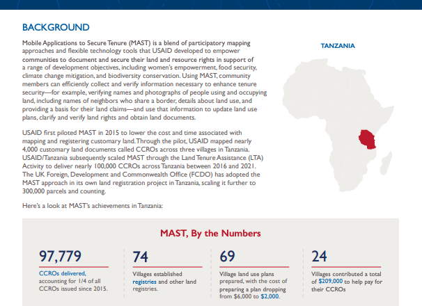
Mobile Applications to Secure Tenure (MAST) is a blend of participatory mapping approaches and flexible technology tools that USAID developed to empower communities to document and secure their land and resource rights in support of a range of development objectives. In Tanzania, USAID implemented MAST in rural areas to lower the cost and time associated with mapping and registering customary land. Through the Land Tenure Assistance (LTA) Activity, USAID helped deliver nearly 100,000 customary land documents across Tanzania between 2016 and 2021.

This infographic highlights the cross-sectoral achievements of MAST in Tanzania, including reduced concerns about future land boundary disputes and land expropriation. To learn more about how MAST improved land and resource governance, among other outcomes, you can access the infographic below.

Perceptions of the MAST Process

PILOT IN LIBERIA’S BLEI COMMUNITY FOREST
Local communities around the Blei Community Forest in Liberia applied USAID’s MAST approach to document land and forest resources. Citizens used MAST to capture land information to make better decisions regarding the use and stewardship of these resources. MAST helped front-line decision-makers identify strategies and actions for their Community Forest Management Plan (CFMP), which provides the framework for safeguarding and sustainably using their customary land and forest resources.


Changes in Land Security and Availability

PILOT IN LIBERIA’S BLEI COMMUNITY FOREST
Local communities around the Blei Community Forest in Liberia applied USAID’s MAST approach to document land and forest resources. Using MAST to map community land boundaries allowed Blei citizens to visualize their land and resource holdings for the first time. Quantifying these resources helped to demonstrate to communities that their customary land-based resources are finite and that they possess fewer resources than assumed.