Integrated Land and Resource Governance Final Report

ILRG Final Report cover imageThe United States Agency for International Development (USAID) Integrated Land and Resource Governance (ILRG) program, a five year (2018-2023) global mechanism, worked with government, private sector, nongovernmental organizations (NGOs), civil society, and community members to strengthen community-based land and natural resource management and advance land-based economic opportunities. Working through a buy-in based approach, with funding from various Washington Operating Units (OUs) and Missions, the geographic and activity scope evolved over time, beginning with initial tasks in Zambia and Mozambique and expanding to field level implementation in Ghana, India, Liberia, Madagascar, and Malawi, as well as research engagements in Colombia, Peru, Democratic Republic of the Congo (DRC), and Indonesia. While country level activities varied, ILRG’s global portfolio largely centered around six key themes, often with multiple themes present in each country.

ILRG set the stage for a number of lasting impacts post-project. The team helped advance a number of inclusive land and natural resource policies and strengthened the capacity of local organizations to take the lead on implementation. The project documented first time land rights for over 500,000 people (50 percent women), increasing tenure security and the potential for increased on-farm investments. ILRG adopted a holistic approach to gender and social inclusion, including the iterative development of a number of manuals/toolkits that are already being used and adapted by other implementing partners and donors in Zambia, Malawi, Mozambique, and India. Companies in the private sector, including PepsiCo in India, Grupo Madal in Mozambique, and Ecom Agroindustrial (ECOM) in Ghana, are taking activities forward using their own resources.

Follow-On Impact Evaluation of the Tenure and Global Climate Change Project in Zambia

This report presents the results of a mixed-methods randomized-controlled trial (RCT) impact evaluation (IE) of the Tenure and Global Climate Change (TGCC) activity in Zambia. The purpose of this follow-on IE is to provide USAID with evidence of the longer-term impacts of TGCC’s customary land formalization and agroforestry components on six different families of outcomes: tenure security; land governance; agroforestry uptake and other climate-smart agricultural investments; agricultural productivity; livelihoods; and food security and women’s empowerment. The IE was conducted by NORC at the University of Chicago under the Communications, Evidence and Learning (CEL) project.

The impact analysis for this IE draws on 3 rounds of household panel survey data collected from 2,313 households across 246 villages, in 2014 (baseline), 2017 (endline) and 2021 (follow-on). Overall conclusions integrate the results from the statistical estimates of impact with additional exploratory analyses, descriptive summary statistics and qualitative data collected across 32 villages at follow-on.

The evaluation findings:

  • Establish longer-term impacts of the TGCC activity nearly seven years after program start;
  • Deepen the knowledge base on efforts to strengthen women’s rights and access to land, and
  • Contribute to informing USAID strategy and programming in land and related sectors.

As one of few RCTs conducted to date in the land sector, the TGCC follow-on IE also contributes to a growing body of evidence on the effects of customary land certification, for whom, and reasons why, across a range of country and customary land contexts in sub-Saharan Africa.

USAID Colombia Oro Legal Final Report

Artisanal Gold Mining – Environmental Impact Reduction Activity (Oro Legal) Final Report

EXECUTIVE SUMMARY

The United States Agency for International Development’s (USAID’s) Artisanal Gold Mining – Environmental Impact Reduction Activity, or “Oro Legal,” was a bold response to the growing social conflict, environmental impact, and governance challenges arising from the most recent gold mining boom in Colombia. Oro Legal recognized that while illegal artisanal gold mining is the basis of illicit economies and drives environmental degradation — and threatens Colombia`s peace-building efforts, citizen security, and democratic governance — it also supports the livelihoods of more than half a million Colombian citizens. The timing of the Activity was apt as it sought to harness the growing awareness and action at all levels of government and increasingly by larger mining companies to create a shared agenda for change in this economically important yet much-maligned sector of the economy.

Oro Legal remains USAID’s largest and most ambitious bilateral initiative in support of artisanal and small gold mining (ASGM) and was implemented in two of Colombia’s emblematic mining departments — Antioquia and Chocó — between September 2015 and April 2021. The Activity grew out of the mining component of the Biodiversity – Reduced Emissions from Deforestation and Forest Degradation Program (BioREDD+), an earlier USAID initiative in Colombia that piloted innovative approaches to improve the social, economic, and environmental performance of small gold miners through legalization and formalization of operations and to mitigate environmental liabilities from past illegal mining.

The Oro Legal intervention strategy was initially underpinned by the conviction that better governance, leading to improved performance in the Colombian ASGM sector, would be brought about through the complex interplay of incentives and disincentives involving a broad array of stakeholders. The expectation was that this would lead to more assertive enforcement of mining, environmental, and other laws, as well as much-needed policy reform for an improved enabling environment, which when combined with high-quality technical assistance (TA) and training, would create tangible economic gains and other benefits for informal miners who became legal and formal, or who transitioned from mining to other livelihoods. The core strategy rested on effective participation between Oro Legal and a range of stakeholders from government, communities and their representative bodies, mining companies, and ASGM operators, as well as greater collaboration among themselves. A further premise was that as a USAID program, Oro Legal would be able to parley its “neutrality,” neither expanding nor limiting mining per se, but rather supporting responsible mining where it proved technically, financially, and legally feasible to do so, in concert with government of Colombia (GOC) counterparts and in alignment with prevailing policy. These core underpinnings were tested and evolved over more than five years of implementation, spanning two GOC administrations.

Oro Legal’s effectiveness and impact were due in large measure to its ability to play the role of a credible and trusted “honest broker.” The Activity was adept at convening stakeholders across groups who have historically had cool and sometime antagonistic relationships to discuss an agenda for change centered on broader, more holistic models around good governance and responsible mining. This extended to a change in attitude and greater involvement of several large mining companies that became committed to legalization of informal ASGM operators on their mining titles or claims, with improvements made in their productivity and environmental management, including the reduction and later elimination of the use of mercury.

Oro Legal´s strategy and interventions evolved in line with a results framework consisting of two objectives and six expected results that underlay higher-level project goals. The strategy also incorporated the then-prevailing USAID/Colombia Country Development Cooperation Strategy to consolidate Colombia’s peace process and contribute to environmental resiliency and improved natural resource management. One of the hallmarks of Oro Legal was a highly adaptive management approach, allowing the Activity to pivot in response to a shifting policy landscape and changing circumstances on the ground to broadly achieve its results, objectives, and goals.

Read more in the full report here.


USAID Land Technology Solutions (LTS) Project: Final Report

Introduction 

In April 2017, Resonance (SSG Advisors LLC) was awarded the USAID Land Technology Solutions (LTS) project, the purpose of which is to improve land and resources governance and strengthen property rights for all members of society in developing countries through the use of mobile technology. By improving, testing, and scaling USAID’s Mobile Applications to Secure Tenure (MAST), the LTS Project will enable host-country stakeholders to document land rights cheaply, quickly, and efficiently.

LTS is envisioned to promote MAST as a scalable, worldwide, “fit-for-purpose” land technology framework and delivery mechanism to make it easier, cheaper, and faster to map and document land rights, and to learn critical information about land and its productivity potential. This knowledge will empower communities to better manage land resources, and make smarter decisions about their land, leading to more productive land-based investments, improved livelihoods, good governance, increased gender equity in access to and control over land, and helping achieve USAID development objectives worldwide.

LTS enables USAID missions to address sustainable investments in land by documenting and clarifying land rights and resources and linking with other information and applications to support decision making across a mission portfolio. Under LTS, MAST is implemented in selected countries to:

  1. Provide a cost-effective, customizable (“fit-for-purpose”) community-based technology framework within sustainable local systems to map and document land rights, and to clarify and secure land-based resources under different tenure regimes.
  2. Facilitate the uptake of “fit-for-purpose” mobile applications at the Mission and host country levels.
  3. Empower communities, especially women, with information and documentation needed to secure land rights, reduce gender equality gaps in land security, and to plan investments in land.
  4. Provide evidence to inform USAID programming in food security, environment, democracy and governance.
  5. Develop a set of tools and resources for USAID and host-country counterparts to determine the applicability of MAST in the local context, the local sustainability of its implementation, and feasibility, and support operations with analytical tools and communications guidelines.

Resonance, and its subcontractors Tetra Tech and Green Advocates, implement work under USAID Contract No. AID-OAA-C-17-00056. This is the second Annual Report summarizing activities and tasks completed during the project’s first year – from April 1, 2018 through August 31, 2019. Project activities have been extended through August 31, 2019 through a no-cost extension mechanism.

Background 

Globally, an estimated 70 percent of land in developing countries is not documented. Land documentation provides people secure land rights and information about their land resources, and without it, people’s ability to make informed socio-economic decisions or long-term, sustainable investments in land suffers. This problem disproportionately affects women, who are globally less likely to own or control land than men. Illustrating this, women’s rate of ownership of agricultural land is significantly lower than their participation in agricultural production in developing countries.

Although many countries have made large investments in reforming their land information and management system, this problem persists. Land documentation remains unattainable for many due to the complexity, length, and expense of the documentation process. Beyond individual households, the ability to document and manage land information is critical to local governments and donors interested in supporting sustainable community development. Without access to secure tenure and information about available land resources, the development potential of land —the greatest asset available to many communities—goes unrealized.

In response to these challenges, USAID developed the Mobile Application to Secure Tenure (MAST), a participatory mapping approach that leverages a suite of low-cost, open-source tools that can be used to document land rights using mobile devices. Individuals and communities can use these tools to secure rights to land and natural resources within customary, indigenous, and statutory tenure regimes.

Building on the successful implementation of MAST in Tanzania, Zambia, and Burkina Faso, USAID designed LTS to update the MAST technology to be more flexible, adaptable, and user friendly, and to pilot new approaches for its implementation. USAID LTS was also designed to provide support to the USAID/E3 Land Office by developing high-quality communications materials and supporting USAID messaging to ensure USAID Missions and host-country stakeholders had sufficient information to deploy MAST. Ultimately, new pilots were launched in Burkina Faso and Liberia though USAID LTS.

Burkina Faso

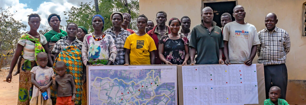
MAST was first implemented in Burkina Faso prior to the beginning of LTS as a way to address land insecurity and increase resilience of rural communities to economic and climate shocks as a part of USAID’s Resilience In the Sahel Enhanced (RISE) portfolio. Communities in the RISE zone in Burkina Faso make a living primarily through agriculture, livestock, and forestry on small family farms. Improvements in land tenure and security could significantly enhance progress toward USAID and Burkina Faso’s development objectives. MAST was seen as a potential means to improve the efficiency and reduce the cost of documenting lands to achieve secure tenure, and was piloted through a partnership between USAID’s Evaluation Research and Communication (ERC) project and the local NGO Observatoire National du Foncier au Burkina Faso (ONF-BF) in the commune of Boudry.

Following the success of the initial launch of MAST in Boudry, USAID ERC and ONF-BF sought to scale up MAST across additional communes in the RISE zone of intervention through collaboration with USAID’s Resilience and Economic Growth in the Sahel- Enhanced Resilience (REGIS-ER) project, which operated in an additional five communes. However, local governments in the RISE zone have limited or no capabilities to implement formal land programs, and customary land tenure patterns are more prevalent than in Boudry. Implementation in the RISE zone required additional capacity building and technical training of local communities and land administration units. In partnership with USAID ERC and REGIS-ER, LTS provided technical support, guidance, and training to ONF-BF and REGIS-ER staff on MAST technology and implementation, as well as monitoring, data collection, and analysis. LTS managed the customization of MAST to the Burkinabe context and provided training on the use of new software modules.

Liberia

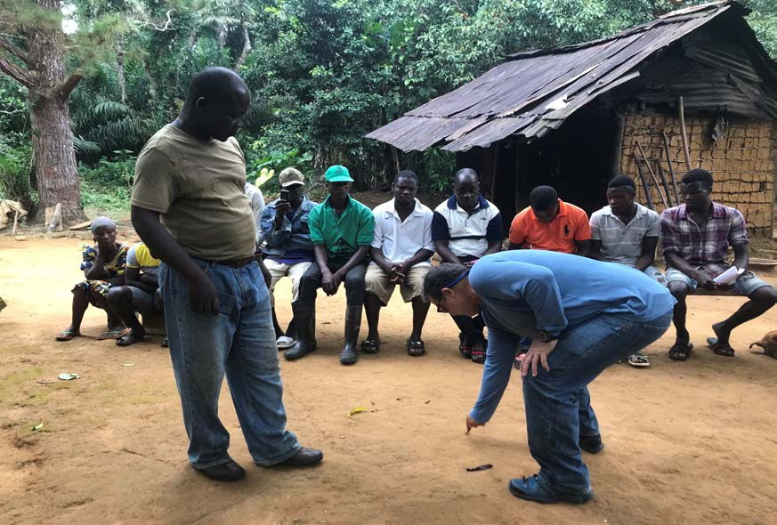
USAID Liberia has invested significant resources supporting Liberia’s community forests under a series of projects (LRCFP, PROPSER, and currently FIFES and indirectly through LGSA). However, the process to establish community forests in Liberia, outlined in the Community Rights Law of 2009, involves a comprehensive, lengthy process to identify, demarcate, and map community forest resources, establish community governance institutions, and to develop a community forest management plan. The LTS pilot in Liberia proposed a new use-case for MAST to improve and streamline the process to establish community forest using MAST’s flexible, scalable and sustainable approach. The pilot sought to test MAST as a means of documenting and building an understanding among beneficiaries of community lands and forest resources for the development of a holistic Community Forest Management Plan (CFMP) to be used in forest management and monitoring.

At the pilot outset, LTS coordinated an assessment trip with Mission staff and USAID FIFES in order to investigate the feasibility of the suggested approach. With these partners, LTS developed an implementation plan for adapting the MAST technology and approach to support forest mapping and demarcation, forest zoning, monitoring and inventory of forest resources around the Blei Community Forest in Nimba County. Working through local partner Green Advocates, LTS engaged seven of the total forty forest communities surrounding Blei Community forest and executed a three-phase pilot. Phases including Forest Resource Mapping and Monitoring, Wider Landscape Resource Consolidation and Mapping, and Development of a Community Forest Management Plan. The pilot demonstrated a new model for community forestry programming based on the MAST approach and technology, with a particular emphasis on community-level engagement.


Land Administration and Management in Haiti Project: Final Report

Executive Summary

Background

Habitat for Humanity Haiti and USAID launched the Land Administration and Management Project (LAMP) in December 2014.

The project had three core objectives:

  • Increase the Outreach and Awareness of Manual 1 and Train Key Stakeholders on its Content
  • Complete and disseminate Manual 2 on “Securing Land Rights in Haiti”
  • Provide Policy Making and Advocacy Recommendations to the GOH

The Haiti Property Law Working Group meetings serve as a platform for the membership to come together to provide input and receive updates on progress made; engage in discussions around security of tenure; and most importantly, provide feedback and guidance on HPLWG products and direction. During the LAMP project, the membership has met, as a Working Group, fifteen (15) times during the year 2016. During the project period the Inter-American Development Bank (IDB) generously hosted the HPLWG meetings at their newly renovated Bourdon campus, in Petion-ville.

The Haiti Property Law Working Group is the only Haitian-led, inclusive forum dedicated to security of tenure issues in Haiti. It’s ability to convene a broad range of actors, both in terms of the value-chain actors (ministries, municipalities, notaries, lawyers, surveyors, etc.); as well as the end consumers and users of policies and procedures (investors, farmers, residents, etc.) is part of its unique qualities, bringing also the legitimacy of the working group.

Through the HPLWG’s approach of consensus building, a significant amount of ownership has been developed by its members. This ownership has opened many opportunities for the HPLWG to increase its outreach and ensuring that the impact of its activities practically reach those who need to be part of this dialogue.

Founded with 24 members in 2011, today the group has more than 300 members representing: Haitian government institutions; Haitian professional associations; universities and students; chambers of commerce; law firms and notaries; private companies; multilateral organizations; non-profit organizations; bilateral agencies and embassies. This representation is all provided on a pro-bono basis leveraging technical assistance and support provided by the members equal to thousands of hours and hundreds of thousands of dollars of value.

Manuals I and II

One of the core contributions the group has made is in the development of the Property Law Manuals. “The Haiti Land Transaction Manual, Vol. 1: A How-To Guide for the Legal Sale of Property in Haiti”. This concise and informative 41-page document is color-coded and details step-by-step the processes for buying and selling land in Haiti. The manual is an indispensable reference guide for navigating the complex formal and informal legal systems in Haiti, and for clarifying and standardizing current legal and customary procedures to sell or buy land – a critical step towards formalized permanent reconstruction and development. The manual outlines the legal steps that lead to well-documented and officially-recognized land transactions.

The second manual “Securing Land Rights in Haiti: A Practical Guide”. The aim of the manual is to help homeowners, farmers, contractors, prospective owners, renters, NGO’s and other interested parties anticipate and prevent complications resulting from the purchase and use of private and public land and property. This is especially important for families who have settled on land for many generations yet still don’t have the paperwork to prove their legal land title status. Thus, the rights to their land are uncertain and securing loans to make home improvements is almost impossible.

LAMP RESULTS

This report details the key outreach activities that have been achieved throughout the duration of the project. Key strategies for outreach have included: awareness campaigns; trainings; meetings; attendance at events; the development of accessibly materials in English, French and Creole.

Almost 5,000 people, across to 7 of the 9 Departments of Haiti, namely: Artibonite, Nippes, Center, North, South, West and Southeast have been exposed to the materials of the Haiti Property Law Working Group. These trainings and awareness campaigns have reach all segments of the population including residents, the professional sector (surveyors, notaries, lawyers), in addition to the Government of Haiti. Upon their request the HPWLG certified trainers, of which there are 21, have trained 10 GOH ministries. Overall, 482 government employees have been trained, including 148 women.

Making the materials accessible to the population has been a priority for the LAMP implementation. This has included the full translation into Creole of Manual 2, in partnership with the Haitian Creole Academy and the Faculty of Applied Linguistics. The development of a visual Creole abstract, illustrating key points from Manual 1 and 2. Additionally, during the field awareness campaigns and trainings, the trainers and Habitat Haiti staff developed an understanding for the common challenges that residents and professionals have. Four case studies were documented and illustrated in Creole and are now utilized to promote the training and discussion with project participants. Over 6,000 manuals and nearly 1,000 Creole abstracts have been distributed and utilized during the project.


Evaluation, Research and Communication Project Final Report

Introduction

Evaluation, Research and Communication Project Final Report August 2018

The Evaluation, Research and Communication (ERC) project was a five-year initiative under the Strengthening Tenure and Resource Rights (STARR) indefinite quantity contract. Implemented from May 2013-July 2018, the goal of ERC was to create, expand and communicate evidence-based knowledge around best land tenure and property rights practices in order to enhance inter­nal USAID and external U.S. Government learning, guide program design and implementation, and make effective use of development resources to accomplish key development objectives. The project was carried out under the direction of USAID’s central land tenure unit, which underwent various restructurings throughout the life of the project and is now the Office of Land and Urban within the Bureau for Economic Growth, Education, and Environ­ment (E3/LU). It will be referred to as the Land and Urban Office throughout this report.

ERC assembled and deployed a highly skilled team of evaluation specialists, communications professionals, subject matter experts in various land tenure disciplines, mapping and graphics specialists, and information technology ex­perts to achieve the project’s goals. The work performed and the results achieved are demonstrated in the graphic above and shown in detail in the main body of the report below.

While the report describes the project’s many successes in detail, two broad successes bear mentioning here. First, the project’s various components, taken together, significantly advanced USAID’s position as a leader and innovator on land-tenure issues in international development. The impact evaluation studies are of a quality that is unsurpassed in the field. The USAID land tenure web site—LandLinks—is a robust platform of knowledge, data, and stories on the human dimension of land tenure that is a “go-to” place for information for development profession­als and other stakeholders. And the communications products, such as the photo library of over 6,000 high-quality images, position USAID to present its work and results effectively going forward.

Second, the project transferred a large amount of knowledge and capacity to developing country stakeholders. Much of the transfer took place through the project’s direct training and information sharing activities such as the Massive Open Online Course (MOOC) and the webinars, but it also took place in the context of other activities in which training was not the central objective. Two notable examples are the training of enumerators from local data collection firms on detailed data-capture methods during the implementation of evaluations, and working with young local specialists from Burkina Faso and Tanzania while implementing the MAST pilot projects. This capacity building will contribute in ways that may not be captured in official project results, but are very real nonetheless and could have significant impacts down the road.

The discussion below is organized in-line with the main project themes: evaluations and research, communica¬tions, training, and pilot projects. For each theme the report describes the work performed, discusses the results achieved, and offers conclusions and recommendations where appropriate.

AgroInvest Final Report: January 2016

In this final report for the AgroInvest project, USAID’s agriculture program in Ukraine from 2011-2016, we discuss the activities and results of AgroInvest in Ukraine. The project’s overall scope of work was developed in 2010 and 2011 to address the issue that Ukraine’s capacity for sustainable, broad-based growth was stalled by unpredictable and incomplete agricultural policies, limited financial services for agriculture, and a weak market infrastructure that led to low yields and made it hard for small and medium producers to become competitive. At a time when agriculture in Ukraine was performing at one-third of its production capability, AgroInvest, implemented by Chemonics International, was developed to assist Ukraine to tap its vast agricultural potential and diversify its sources of prosperity, leading to broader economic recovery and contributing to a more food-secure world.

Severe financial, political, and social crises continue to plague Ukraine. In late 2013, mass protests against the pro-Russian politics of former Ukrainian president Victor Yanukovych triggered his ouster, which, in turn, was followed by Russia’s illegal annexation of the Crimean peninsula and military conflict in the east of Ukraine. In response to separatists’ declarations of unrecognized “people’s republics” in Donetsk and Luhansk through illicit referenda in spring 2014, Ukraine’s newly formed pro-reform launched a full-scale military anti-terrorist operation (ATO) against them. President Petro Poroshenko, elected in May 2014, has steadily pushed for a solution to the crisis in the East. Since the conflict broke out in early 2014, the fighting has resulted in thousands of deaths and massive internal displacement of civilians. According to the United Nations Office for the Coordination of Humanitarian Affairs, the number of internally displaced persons (IDPs) in Ukraine has reached more than one million, the largest displacement of people in Europe since the Balkan wars. Most of these individuals live in eastern oblasts near the conflict areas, such as Kharkiv, Dnipropetrovsk, Zaporizhzhia, and Northern Donetsk. Numerous attempts to broker an end to the conflict have been unsuccessful as ceasefire agreements, commonly referred as Minsk I and II, have been largely ignored. The ongoing conflict has also triggered a financial crisis across the country that has seen the Ukrainian hryvna lose more than 50 percent of its value and has resulted in extensive decreases in domestic and international investment in Ukraine across all sectors.

The ongoing crisis presented unique challenges and opportunities that required rapid and innovative thinking to, in the words of the USAID Mission, “pivot” activities to address the rapidly changing situation in Ukraine. One such challenge was Russia’s illegal annexation of Crimea, where AgroInvest had numerous activities and partners. In mid-March of 2014, AgroInvest (and all USAID programming) had to cease all activities in Crimea. With this crisis came an opportunity; the leadership of the Ministry of Agrarian Policy and Food (MAPF) of Ukraine that came in when President Poroshenko took office was more progressive and open to collaborating with AgroInvest than any other MAPF management team with whom AgroInvest had historically worked.

Yet despite these crises, AgroInvest has achieved outstanding results. Over the life of the project, AgroInvest and its partners helped support the development of more than 75 pieces of draft legislation and the passage of 12 policies, regulations, and administrative procedures through processes that ensured public and stakeholder consultation, facilitate more than $80 million in critically needed agricultural finance, and strengthen the administrative and technical capacities of 20 agricultural service cooperatives and 32 agriculturally focused industry associations. These and other activities and highlights of AgroInvest’s five eventful years of implementation are elaborated on throughout this document.

Tenure and Global Climate Change (TGCC) Program Final Report

The Tenure and Global Climate Change (TGCC) program carried out evidence-based interventions around community-based, participatory land and resource documentation to build local self-reliance and economic prosperity for marginalized and vulnerable populations. By building platforms for communication and conflict resolution among stakeholders, including local communities, government, and the private sector, TGCC identified pragmatic solutions to strengthen land and resource rights, implemented through partnerships with local civil society organizations. Between 2013 and 2018, TGCC achieved the following:

5

Field pilot interventions implemented across five countries and three continents

604

Communities mapped their boundaries and resources through bottom up participatory processes

14,871

Household land certificates produced and managed by customary leaders in Zambia covering 190,297 hectares (52 percent included female landholders and 20 percent included exclusively female landholders)

145,937

Hectares of land placed under improved natural resource management

61,590

Tons of greenhouse gas emissions reduced through agroforestry and two additional deforestation-focused partnerships through Tropical Forest Alliance 2020

19

Policy and legislative processes supported, including two Land Policies incorporating unprecedented consultation for Burma and Zambia

Partnerships with international businesses and national and global platforms to encourage integration of land tenure lessons into business practices

Donor and private sector coordination led to leveraging of USAID pilot methodologies for future replication in five countries

Spatial data on community land rights integrated into publicly accessible platforms in three countries

3

Toolkits developed for household and community land documentation and spatial planning

19

Local land and resource tenure assessments conducted across thirteen countries

11

Civil society organizations supported to carry out mapping with their constituents

152

Public presentations of results and impacts to global, US, and host country communities of practice on climate change mitigation and adaptation, as well as land tenure and property rights

Read the full report below.

Sustainable Forests and Coasts Final Report

Ecuador ranks among the top 17 megadiverse countries in the world. Recognition of its vast natural heritage is enshrined in the country’s 2008 Constitution, and celebrated in the constitutional principal of Buen Vivir — the coexistence of humans with nature. For several decades the Government of Ecuador (GOE) has led internationally recognized efforts to slow deforestation of Ecuador’s natural forests and mitigate additional damage to marine and terrestrial ecosystems caused by over-exploitation of resources, population pressures, and climate change.

To complement the GOE´s efforts, the USAID Sustainable Forests and Coasts Project aimed to simultaneously create long-term improvements in conservation and the lives of the poor along Ecuador’s coast through a $15.7 million initiative implemented from June 15, 2009, to June 14, 2014. The presence of large human settlements along the coast — including Guayaquil, Ecuador’s largest city — have resulted in the coast experiencing some of the severest threats to biodiversity. The project worked closely with the Ministry of Environment (MAE), local governments, communities and producer groups along the coast to promote practices, processes, and GOE programs that connect economic benefits with improved management of the natural resource base upon which the livelihoods of Ecuador’s residents depend.

OBJECTIVES AND ACCOMPLISHMENTS

The project´s main goal was to conserve biodiversity in critical habitats along the Ecuadorian coast and benefit communities that live in and/or around these areas while forming lasting partnerships for conservation.

The project´s implementation approach focused on reducing key threats to biodiversity. Within each site, the project established priorities and guided work planning based on analysis of the following threats to conservation: (1) loss and/or alteration of critical habitats, (2) climate change, (3) lack of economic alternatives, and (4) insufficient institutional capacity for biodiversity conservation.

In response to these threats, Sustainable Forests and Coasts developed activities that provided complementary benefits across the project’s three main objectives: (1) Improvement of biodiversity conservation in critical habitats; (2) Improvement in local livelihoods; and (3) Formation of partnerships for ongoing support for biodiversity conservation. The project advanced a wide set of practices, methodologies, and tools to benefit stakeholders ranging from rural farmers to MAE staff, and also furthered multi-stakeholder platforms to bring actors together and coordinate shared conservation goals.

Biodiversity conservation: Since much of the forest coverage has vanished on the Coast of Ecuador, the project’s primary objective was to preserve the remaining critical areas of biodiversity. Most of these areas are government managed Protected Areas (PA) and their buffer zones, as well as indigenous lands. Project interventions resulted in 427,227 hectares of terrestrial area of biological significance under improved management, 317,105 hectares of coastal marine area under improved management, and 4,838 people trained in natural resource management and or biodiversity conservation.

Noteworthy project successes included:

  • Expansion of conservation corridors by assisting communities and individuals to apply for the MAE’s Socio Bosque cash-for-conservation program and mangrove concession partnerships, in addition to streamlining application procedures to facilitate future applications to the programs;
  • Support for two extensive monitoring and surveillance systems;
  • Introduction of land use planning models and a model for determining climate change adaptation measures;
  • Assistance for the creation of the Guayas Province climate change adaptation strategy; and
  • The piloting of mutually beneficial approaches to the relationships between communities living in and around PAs and the government officials who monitor these areas.

Local livelihoods: The inhabitants in project sites are primarily subsistence-level farmers and fishermen in extreme poverty, and these remote areas faced commercial barriers such as high transportation costs and lack of infrastructure. Despite these challenges, the project adopted a market driven strategy to improving livelihoods and conservation by serving as an honest broker between producers and environmentally responsible markets. Many project activities took the form of pilots with selected crops in specific communities — for example, artisanal ivory nut production in Matapalo and La Crucita, and improved crab processing in 6 de Julio — with the intention of establishing good practices for the communities to build upon and lessons learned for replication elsewhere.

Noteworthy project successes included:

  • Application of good agricultural practices with 185 farms in the Ayampe and Galera San Francisco watersheds, with the introduction of better water systems management, reduced agrochemical use, and other practices that resulted in cost savings and also provided co-benefits for climate change adaptation; and
  • Twenty-two new commercial linkages that resulted from project support, with more than 16,225 people enjoying increased economic benefits as a result of these linkages, better management practices, and conservation incentives.

Partnerships for conservation: Initial assessments determined that insufficient institutional capacity and poor communication between stakeholders pose limitations to coordination of biodiversity conservation in the project areas. The project formed strategic partnerships with the National Fisheries Institute (INP), the Guayas provincial government, municipal governments, and communities in each of its four project sites.

With these partners, noteworthy project success included:

  • Formation of five conservation coalitions with public and private sector stakeholders that continue to serve as a venue for coordinating regional conservation priorities;
  • A historic survey of the red crab population, undertaken jointly between the INP and more than 940 local fishermen under the coordination of the Gulf of Guayaquil coalition;
  • Inputs for the review of national-level forestry policies; and
  • Piloting of a methodology for management planning in 25 PAs that has received international attention.

CHALLENGES AND LESSONS LEARNED

The project had a wide geographic scope and ambitious set of goals, given the structural barriers faced by many project beneficiaries. Increasingly severe climatic variability and the poverty in beneficiary communities were external challenges both to biodiversity and to the project itself, particularly for the design of sustainable value chains with a viable scale and scope. The process of establishing trust with stakeholders was long and experienced setbacks as a result of a general distrust of international actors in some communities, fluctuating USG-GOE relations, and regular turnover of MAE staff especially at the provincial level. The changing of attitudes and demonstration of the economic benefit of altered practices takes time, particularly when it involves agriculture and aquaculture-based activities with determined seasons and multi-year productive cycles. The project’s five-year implementation period was short in the context of the long-term changes the project sought to bring about.

The project operated with an adaptive management style that allowed it to learn from failures as well as successes, and to adjust resources and activities accordingly. It worked through pilot projects that could determine potential benefits from conservation-oriented productive activities and then demonstrate the results to other beneficiaries who may have been reluctant — or unable — to invest the time and resources toward changing practices without clear incentives. The project’s local partner organizations, MAE and other government counterparts, and the beneficiaries themselves will be the stewards of project’s methodologies, processes, and approaches moving forward.

Lessons learned through the Sustainable Forests and Coasts Project are summarized throughout the report, and include:

  • Governments seeking to effectively regulate resource use should approach communities living in and around PAs as allies for conservation, not as adversaries.
  • A focus on regulating resource and land use rights, instead of regulating land ownership rights, will engage communities and provide the framework for more effective, community-based conservation strategies.
  • Although land in project sites was frequently under communal ownership, “community” enterprises were rare. Support to communities for regulatory frameworks was paired with support to family units for productive activities that supplemented household income.
  • Good agricultural practices and better land use planning at the watershed, community, and farm level yield important and necessary co-benefits for climate change adaptation.
  • Driving site selection by conservation criteria resulted in sites whose economic growth potential was extremely limited. The project needed to orient productive projects toward the modest expansion of subsistence livelihoods, with the constraints of producers’ capacity taken into consideration.
  • The project’s short duration limited its potential to provide the extensive assistance communities needed to build the skills for market participation and secure the sustainability of market linkages.
  • The establishment and/or strengthening of local and regional cooperatives and producers’ associations will give small producers leverage to eliminate middlemen and collectively achieve economies of scale.
  • Close collaboration with local counterparts, including local subcontractors, helped the project introduce itself and gain beneficiary trust. Additionally, local grassroots organizations, with appropriate guidance, can advance project agendas and promote sustainability through a continual field presence in a way that national or Quito-based organizations may not be able to.
  • Increasing the number of hectares of biological significance under improved management does not necessarily imply or yield greater conservation impact. Measuring the changes in management quality is as important as measuring increases in the number of hectares, given the wide range of threats that critical habitats face.

Tanzania SERA Policy Project Final Report

The USAID-funded Tanzania SERA Policy Project provided research on over eighteen different policies that affected agriculture during the five and one-half year life of the project. It also improved the capacity of Tanzanians to undertake policy analysis and advocate for an improved policy environment. The impacts of this research and enhanced capacity has been to improve the current policy environment, better the ability to monitor and respond to food security challenges and market opportunities, and provide a basis for which for future improvements in the policy environment can be advanced.

The most significant improvement to the current policy environment came from research on the impacts of the food crops export ban which led the GOT to lift the export ban in 2012. This provided farmers with better market opportunities and higher prices for their marketed maize and other food crops. SERA research showed that an export ban reduced farm-gate prices by about 25 percent and as a result of the SERA research there has not been an export ban since 2012, compared to five in the six years prior to 2012. This led to better prices since 2012 and provided incentives for farmers to increase production, increase investments, and provide a better life for their families. The financial impact of lifting the export ban is difficult to measure, but the loss to farmers from the 2011 export ban was estimated to be USD200 million. Tanzania has recorded consecutive good harvests since the export ban was lifted and that was due in part to the lifting of the export ban. There is a regional shortage of maize in 2016, and if the Government were to ban exports, it would result in large losses as in 2011, while increasing illegal exporting and encouraging corruption.

SERA research also contributed to a better understanding of food security and the ability to monitor food costs at the regional level in Tanzania, and contributed to the establishment of a Market Intelligence Unit that will be able to continue that effort in the future. Among the important findings was that diets in Tanzania are quite diversified and no single food item accounts for more than 15 percent of the cost of the typical food basket. Prices of major food items are not highly correlated which means consumers can adjust to changing prices by switching to other food items which have not experienced large price increases. SERA research on food demand also identified those foods that are expected to have rapid demand growth in the future and that information can be used to guide future investments so that the food system meets the needs of the population.

SERA support for a better policy environment for the agriculture sector will continue through producer organizations that were strengthened and reforms that were started by SERA and will continue after SERA has closed. These include an improved working relationship between the private seed companies and the GOT, the strengthening of the producer and industry associations (Rice Council of Tanzania and the Agriculture Council of Tanzania), and planned reforms of the secured transactions law and the establishment of a collateral registry by the Bank of Tanzania (BoT). Strong producer associations can raise policy concerns with Government and influence these policies as was recently demonstrated by the Rice Council when they raised the issue of illegal rice imports. Contributing to better dialogue between the seed industry and the GOT is important because it will lead to greater availability of improved seeds which have been shown to result in a 30 percent increase in crop yields. Improved credit to smallholders and SMEs will increase the ability of smallholders to finance investments and increase productivity, and SERA efforts led the BoT to prioritize this activity and the World Bank to support implementation.

SERA research also examined other important issues such as gender, the agriculture business environment, emergency food imports, and maize and rice market performance. The study on gender showed that female-headed households are severely disadvantaged compared to male-headed households with respect to land holdings, input use, yields, production, prices received, and incomes. This research could be used to support the development of specialized extension programs to focus on female farmers and reduce their poverty. The study of the agriculture business environment showed that Tanzania is not competitive in attracting foreign investors and new incentives are needed. This research also largely explains why the Southern Agricultural Growth Corridor of Tanzania (SAGCOT) has not been able to attract foreign investors and it is unlikely to be successful in the future without major reforms. It is conceivable that if this study had been conducted before the SAGCOT initiative was started, the outcome may have been very different. The study of the emergency food import policy recommended the establishment of a Market Intelligence Unit to monitor food prices and that unit is being established and training was provided by SERA project. The studies of market efficiency showed that prices are slow to adjust to regional price changes and better information systems and better internal transport would result in higher prices to farmers and lower prices to consumers.