Tanzania Demand for Documentation Case Study: Who Pays for Land Documents, and Why?

Tanzania Demand for Documentation case study cover imageDespite strong evidence on the importance of land documentation for landholders’ tenure and economic security, among other benefits, national governments are often constrained in their ability to map and title property at scale. First-time land registration is often provided at no cost to the landholder but may be unsustainable for country governments and service providers. In the context of customary land systems, the beneficiary contribution models ask landholders to contribute some portion of the registration costs to obtain official documentation of land rights, but the approach could have implications for documentation access and equity.

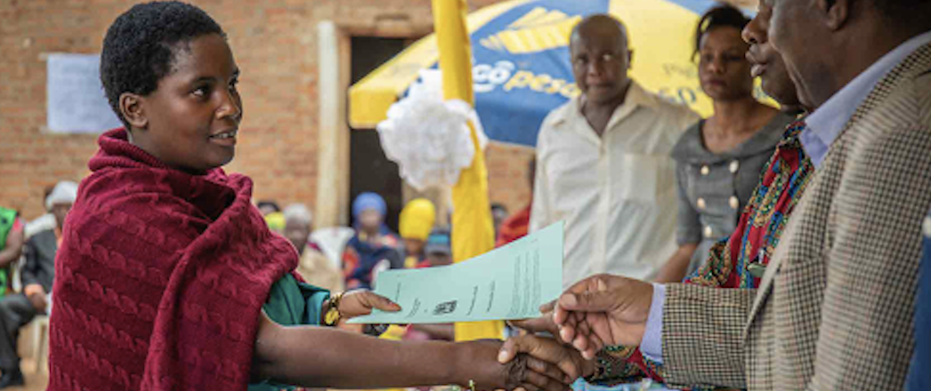
This study utilizes a mixed methods approach that draws on analysis of land registration data from a USAID-supported customary land formalization program in Tanzania, coupled with a follow-up household survey and qualitative data collection, to better understand rural Tanzanians’ willingness and ability to pay for government-issued and legally recognized customary land documents. The program operated in two phases, initially providing Certificates of Customary Right of Occupancy (CCROs) to landholders for free, and then requiring landholders to pay a nominal fee to obtain the document.

The study results suggest that to increase equity and reduce barriers to widespread uptake, programs can consider: installment payments to overcome cash flow constraints; increasing access to bank agents and mobile money payment modalities; quality control to avoid unauthorized payment collection; and a strategy to identify the most vulnerable landholders for subsidized payment support.

USAID REDD+ Outlook: Cambodia Case Study

ILRG Cambodia case study cover imageThe United States Agency for International Development (USAID), through its missions and implementing partners, supports market-driven climate change mitigation initiatives based on protecting forest landscapes in various countries globally, including Cambodia. Known as REDD+ (reducing emissions from deforestation and forest degradation), these initiatives not only provide environmental and climate benefits, but also generate livelihood and social outcomes for rural, forest-dependent communities. Cambodia is a country that has received significant REDD+ support from USAID since 2012. USAID funding supports up to 10 REDD+ projects which cover key protected areas and forest landscapes.

The evolution of REDD+ and recent criticisms have raised questions about the integrity and quality of REDD+ voluntary carbon market (VCM) projects (Greenfield, 2023). In this context, USAID seeks clarity on the current landscape of REDD+ and how its bilateral investments can best support REDD+ projects and programs in Cambodia moving forward. This assessment was commissioned to provide USAID and its partners an overview of the current discourse and criticisms of the REDD+ voluntary marketplace, ongoing efforts to address these challenges globally, and the role that USAID funding has played and can continue to play specifically in REDD+ in Cambodia.

This report is structured as follows: Chapter 2 provides an overview of REDD+ as an instrument and the main issues besetting the REDD+ landscape globally today. Chapter 3 delves into the specific context of REDD+ in Cambodia, covering the recent updates of the national-level REDD+ policies and implementation and an overview of the REDD+ activities in the country. It also discusses the role USAID funding has played in REDD+ projects. The final chapter synthesizes the main takeaways for USAID and sets forth concrete recommendations on how USAID can continue to contribute and amplify its investments through REDD+ in Cambodia.

A Decade in the Making: The Evolution of Mobile Applications to Secure Tenure (MAST)

Introduction

Mobile Applications to Secure Tenure (MAST) is a blend of participatory mapping approaches and flexible technology tools that USAID developed to empower communities to document and secure their land and resources rights in support of a range of development objectives ranging from women’s empowerment and food security to climate change mitigation and biodiversity preservation. The MAST approach provides flexibility to accommodate different technology options, including mobile apps and web-based data management platforms, designed and adapted to help communities document their rights quickly and affordably. MAST’s participatory mapping methodology emphasizes on-the-ground engagement and training to empower citizens as data collectors and build their capacity to maintain land information and manage their land and resources. Using MAST, community members can efficiently collect and verify information necessary to enhance tenure security—for example, verifying names and photographs of people using and occupying land, including names of neighbors who share a border, details about land use, and providing a basis for their land claims—and use that information to obtain land documents.

The concept behind MAST was first conceived in rural Ghana a decade ago, but it took until 2014 for the idea to become real. Since then, MAST has moved from a small pilot in Iringa District, Tanzania to a multi-country approach that USAID and partner organizations have used to map and document more than 93,000 land parcels across Tanzania. The UK Foreign, Development and Commonwealth Office (FCDO) has adopted the MAST approach in its own land registration project in Tanzania, scaling it further to 300,000 parcels and counting. MAST is now also being deployed in Mozambique, Zambia, Liberia, Malawi, and Ghana.

This case study examines the evolution of the MAST approach, from conception to piloting, assessment, and scaling. This work demonstrates how MAST can be used to address issues including poverty reduction, women’s empowerment, conflict prevention, and food security. It also demonstrates how a land documentation approach such as MAST can iterate and adapt to new contexts and challenges and, in the process, take on new forms and functions.

Read the full case study.

Leveraging MAST in Natural Resource Management: Cross-Sectoral Uptake Throughout Tanzania

Mobile Applications to Secure Tenure (MAST) is a blend of participatory mapping approaches and flexible technology tools that USAID developed to empower communities to document and secure their land and resources rights in support of a range of development objectives ranging from women’s empowerment and food security to climate change mitigation and biodiversity preservation. The MAST technology suite consists of a mobile app and a web-based data management platform designed to help communities document their rights quickly and affordably. MAST’s participatory mapping methodology emphasizes on-the-ground engagement and training to empower citizens as data collectors and build their capacity to maintain land information and manage their land and resources. Through MAST, community members can efficiently collect information necessary to enhance tenure security— for example, names and photographs of people using and occupying land, names of neighbors who share a border, details about land use, and a basis for their land claims. Households can then use that information to obtain land documents.

In Tanzania, MAST has been scaled from a small pilot that delivered 900 customary documents called Certificates of Customary Right of Occupancy (CCROs) in the village of Ilalasimba to a nation-wide program that a variety of donors and organizations including USAID, the U.K. Foreign, Development, and Commonwealth Office (FCDO) and others have used to deliver nearly 400,000 CCROs and counting.

Map of Tanzania showing programs that have evaluated or used MAST.

This case study examines cross-sectoral applications of MAST beyond land tenure to sectors ranging from conservation to water and sanitation. View the full case study here.

Case Study: Artisanal and Small-Scale Mining in Madre De Dios, Peru

 Introduction

The uncontrolled expansion of artisanal and small-scale gold mining (ASGM) sector is a significant threat to biodiversity across many Amazonian countries (The CADMUS Group 2019). The effects of the ASGM sector can range from local habitat degradation or destruction to larger-scale pollution, sedimentation, and mercury bioaccumulation in watersheds. These environmental impacts are often accompanied by a suite of negative social effects, including health issues from mercury exposure, high incidence of anemia among exposed children, increased prevalence of tropical diseases such as malaria, and a lack of access to health, education, and sanitation services in mining camps (Weinhouse et al. 2017). Illegal mining is also associated with organized crime, narcotrafficking, trafficking in persons, child labor, and sexual exploitation, all of which are prevalent at illegal mining sites (DOL 2018; GIATOC 2016). Yet both sectors, the artisanal and small-scale mining (ASM) more broadly and the ASGM specifically, offer the promise of reducing poverty for many populations with few livelihood options.

Globally, 40 million people participate in the ASM sector, and in Latin American countries, the sector supports tens to hundreds of thousands of workers (Intergovernmental Forum on Mining, Minerals, Metals and Sustainable Development 2017). Despite the profound socio-environmental impacts generated by the uncontrolled expansion of these activities, economic gains make addressing illegal ASGM a challenge.

The legal and illegal ASGM sector is widespread in Peru, the largest producer of gold in Latin America and the sixth-largest in the world (OECD 2016). In 2019, the ASGM sector generated 22 percent (27.7 metric tons) of gold production in Peru (MINEM 2020). The number of miners directly involved is uncertain, but government reports suggest between 300,000 and 500,000 miners were involved in Peru’s ASGM sector as of 2014 (Defensoría del Pueblo 2014).

Informal ASM and ASGM in Peru are widespread. The government is working to formalize these sectors, resulting in more than 51,000 miners and 8,000 miner associations in the process of formalization in Peru as of April 2020 (REINFO 2020). While the ASGM sector is present across the country, the department of Madre de Dios is the epicenter of illicit alluvial gold extraction and the accompanying deforestation. For this reason, it is the focal point of the Peruvian government’s attempt to control the environmental and human rights abuses of the illegal ASGM sector.

This case study examines the complex drivers behind ASGM sector expansion, the devastating impacts on biodiversity in the region, and the strategies implemented to address the impacts of ASGM in Madre de Dios by the Government of Peru, with support from the United States Agency for International Development (USAID).