In Burma, weak land tenure security and unsustainable land use management are issues faced by many rural communities. Reasons for this include a poor understanding of existing land legislation, the involvement of multiple government departments in land administration, and a failure to recognize community-based land rights. The issues are particularly acute for landless citizens in these communities.
Daw Thin Yee, a resident of Yway Kone village, said, “Since landless members of our community like me have lost access to communal lands, we have a big problem grazing cattle and collecting thatch for our homes.” Such situations may lead to future land disputes and conflict, as well as inhibit smallholder agricultural development.
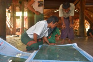
To address this situation, the Land Tenure Project (LTP) has brought together relevant stakeholders, including local authorities, community members, and civil society groups, at the Yway Kone Village Tract pilot site to document the perceived land rights of communities. Project staff have provided educational materials and technical support through a process that begins with community sensitization to land issues and continues with participatory mapping activities undertaken at a series of community events.
Nicholas Thomas, Country Coordinator for the project, stated, “The information gathered with the support of all stakeholders will serve communities well in communications with local authorities and private companies in the event of access and land use disputes.”
Community members appreciate the outputs of the work to date and understand how they will support their land rights in the future. As work continues into 2016, community boundary information will be supplemented by community-level land use inventory data that can then be used for sustainable land use planning.
USAID’s support has resulted in information products, including map data that, for the first time, accurately describe the perspectives of community members and can be used by them when discussing land resource issues with local authorities. Community empowerment through information generation and exchange as witnessed by LTP actions provides others interested in community land tenure in Burma with a framework for work in additional areas throughout the country.