What Corporations and Smallholder Farmers Have in Common: Addressing the Challenge of Land Rights in Emerging Markets

This article was originally published on the Next Billion website

By: Mary Hobbs, Director for the Agriculture, Environment, and Business Office, USAID/Mozambique

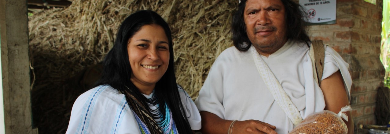
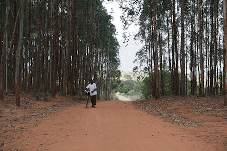
Mozambican farmer Lucia Maurício farms about 10 hectares (25 acres) of land to feed her five growing children.

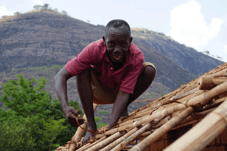
Portucel Executive Director Paulo Silva manages more than 13,000 hectares (32,000 acres) of eucalyptus farms in Mozambique to feed a growing multi-million-dollar global supply chain hungry for paper pulp.

They have more in common than you might think.

Both require the same foundation to achieve their goals: clear and documented land rights.

Just as clear and documented land rights allow farmers to invest in their land to improve their harvests and their lives, they allow investors and corporations to more easily identify farmers and communities with surplus land, and to negotiate to access or lease the land they need to keep their company running.

Land rights are an underappreciated precondition across the agriculture spectrum – from the largest agriculture companies to subsistence farmers, their foundation for success is documented and secure land tenure.

This may sound like a simple requirement, but in Mozambique and many other sub-Saharan African countries, that foundation had not yet been laid. According to the World Bank, only 10% of agricultural land in sub-Saharan Africa is documented. In Mozambique, where Lucia farms and Paulo works, the FAO says only about 20% of land is documented. Those figures haven’t changed much in decades – trapping farmers like Lucia in poverty and providing hurdles to investment for investors like Paulo.

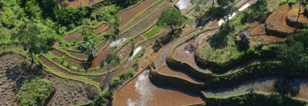
Most farmers in Lucia’s village of Enhumua farmed without titles or deeds to the land they rely on. They farmed land passed down to them or bought on a handshake. The contours and boundaries of each parcel were rarely noted on paper.

And when land tenure is unclear or undocumented, both farmers and businesses suffer.

This was the case for Lucia. Previously she could not capitalize on the most fertile section of her land because of conflicting claims. The parcel was by the river, well irrigated, and blessed with rich, productive soil. But her neighbors also claimed the land. And this threat influenced the way she farmed. Instead of trying to maximize profits, she and her husband Calisto tried to minimize their risks. Despite the land’s potential, she planted only corn on the parcel. She feared that if she planted other vegetables, which are much more profitable, her neighbors would take the investment as an irresistible invitation and seize some or all of her crop along with her land.

This type of conflict over land has long been common, and it intensified in 2010, when the government granted approximately 173,000 hectares of land in Zambézia province (which includes Lucia’s village of Enhumua) to Portucel-Mozambique to establish large-scale eucalyptus farms. Zambézia is the second most populous province in Mozambique. So across Zambézia, villages like Enhumua do not have a lot of vacant and unused land.

Portucel staff immediately recognized the challenges of operating a business in such an uncertain environment when they began negotiating with villagers to lease land. In Namalapa village, not far from Enhumua, Joao Ernesto Prego received an unwanted surprise when Portucel claimed rights to 3.5 hectares of his land. Joao’s nephew had signed over rights in exchange for a promise of lifetime employment with Portucel.  Portucel had a signed document from the nephew, and Joao found he had little recourse.

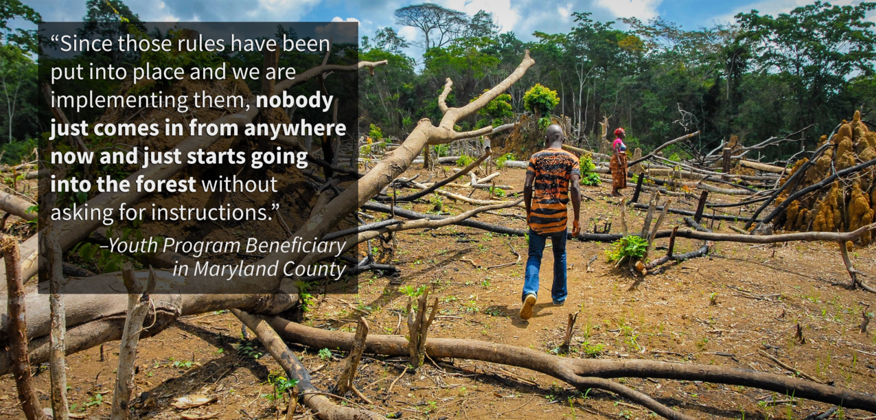
As the company’s eucalyptus farms sprouted across the horizon, similar stories – born of a tangled web of unclear and undocumented land tenure – multiplied. Eventually, as with many companies, Portucel ceased all land procurement negotiations and put future investments on hold while they worked out how to responsibly negotiate with and invest in communities where land tenure is undocumented and unclear. Land disputes can very easily escalate, creating tensions in a community that make it unsafe for families and businesses alike.

A bicyclist walks through Portucel’s eucalyptus plantation.

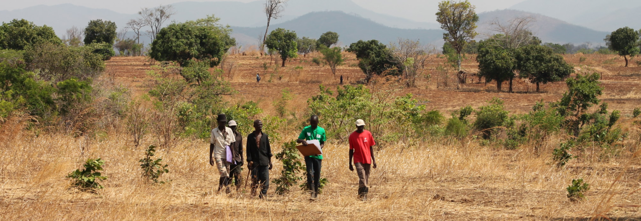
The company’s hopes for the future, along with those of Lucia and other farmers, soared when USAID and DFID-funded programs to document smallholders’ land rights came to the region. The programs trained farmers like Lucia to document land boundaries with GPS technology.

Farmers walk the boundaries of their land, GPS in hand and witnesses in tow, to map their properties. Each farmer is provided with a certificate signed by local leaders that includes a satellite map of the farm, GPS coordinates, the farmers’ names, and the names of community leaders and witnesses.

The certificates provide smallholders like Lucia and Calisto with their first documentation of their land rights. This added security has been transformative for Lucia, her community and Portucel. When farmers like Lucia have secure rights to property, they can negotiate with businesses to loan or lease their land, or arrange an out-grower contract with a company like Portucel and enter the global marketplace.

With clearly documented land boundaries, Portucel can finally identify landowners with surplus land and negotiate to access or lease it. They can also identify vacant parcels and pursue options for leasing that land from the government or communities.

Portucel hopes these changes will enable it to reduce its investment risk and increase the sustainability of its business. As Paulo Silva says, “Now, in a vast area of our holdings, we all know the right locations of the plots of people living there, creating better conditions for dialogue between the company, communities and individuals. This allows us to better plan for the future.”

Martins Gabriel Paiva putting a new roof on his home.

Lucia certainly wasted no time in taking advantage of her newfound confidence in her land rights. She is planting a vegetable garden on her prized parcel and, with the proceeds from that harvest, will gain a measure of self-reliance heretofore unimaginable. She and her husband expect the vegetable plot will quadruple their income. Such a jump in their earnings would finally allow them to put a much-needed zinc roof on their home, support their children’s education, and improve the productivity of their other fields with investments like fertilizer or better-quality seeds.

“We can farm as we please,” says Lucia with a smile. “Life is good now.”

Martins Gabriel Paiva, a village chief often called upon to settle land disputes, has also noted the change brought by better documentation of land rights. “In the past there was constant conflict over land,” he says. “Now there is harmony.”

Martins notes that Lucia’s story is being replicated across the district. “The land thieves now know that every parcel has an owner,” he says. “We are now kinder to each other. We have a community group that has the people’s trust and it is working on building a community fishpond.”

“Now,” he adds, “we can improve our development.”

Mary Hobbs is the Director for the Agriculture, Environment, and Business Office at USAID/Mozambique.

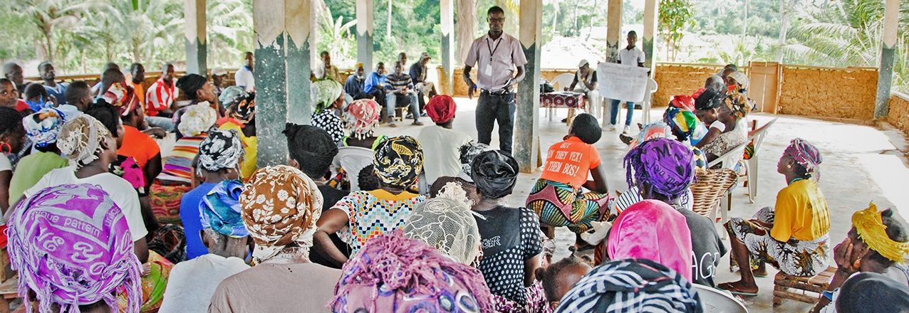
Photos courtesy of Mary Hobbs – USAID. 


Are medium-scale farms driving agricultural transformation in sub-Saharan Africa?

T. S. Jayne,  Milu Muyanga, Ayala Wineman, Hosaena Ghebru, Caleb Stevens, Mercedes Stickler, Antony Chapoto, Ward Anseeuw, Divan van der Westhuizen, David Nyang

This study was supported by: (i) the Food Security Policy Innovation Lab, led by Michigan State University and funded by USAID/Bureau for Food Security; (ii) the Agricultural Policy Research in Africa (APRA), led by the Institute of Development Studies/Sussex and funded by DfID/UK; (iii) the CGIAR Research Program on Policies, Institutions, and Markets (PIM); (iv) the Africa Agricultural Policy Unit at the World Bank; and (v) the Agriculture and Agroindustry Department, African Development Bank.

Abstract

Download the full report

This study presents evidence of profound farm-level transformation in parts of sub- Saharan Africa, identifies major sources of dynamism in the sector, and proposes an updated typology of farms that reflects the evolving nature of African agriculture. Repeat waves of national survey data are used to examine changes in crop production and marketed output by farm size. Between the first and most recent surveys (generally covering 6 to 10 years), the share of national marketed crop output value accounted for by medium-scale farms rose in Zambia from 23% to 42%, in Tanzania from 17% to 36%, and in Nigeria from 7% to 18%. The share of land under medium-scale farms is not rising in densely populated countries such as Kenya, Uganda, and Rwanda, where land scarcity is impeding the pace of medium-scale farm acquisitions. Medium-scale farmers are a diverse group, reflecting distinct entry pathways into agriculture, encouraged by the rapid development of land rental, purchase, and long-term lease markets. The rise of medium-scale farms is affecting the region in diverse ways that are difficult to generalize. Findings indicate that these farms can be a dynamic driver of agricultural transformation but this does not reduce the importance of maintaining a clear commitment to supporting smallholder farms. Strengthening land tenure security of local rural people to maintain land rights and support productivity investments by smallholder households remains crucial.

Introduction

Ever since the critical acclaim given to the Asian green revolution starting in the 1980s, it has been widely accepted that a smallholder-led growth strategy would also be the pathway for achieving economic transformation and mass poverty reduction in Africa. Over 90% of farms in South and East Asia were smaller than two hectares at the beginning of the Green Revolution (Hayami & Ruttan, 1971; Johnston & Kilby, 1975). Because small-scale farms also constitute the vast majority of farms in Africa, agricultural economists have generally accepted that a smallholder-led strategy also holds the best prospects for agricultural development in Africa (e.g., Hazell, Poulton, Wiggins, & Dorward, 2010; Mellor, 1995).

However, parts of sub-Saharan Africa (SSA) are witnessing rapid changes in farm size distributions. “Medium-scale” farm landholdings of five to 100 ha now account for a substantial and growing share of farmland in many African countries (Jayne et al., 2016).1 Perhaps ironically, the amount of land acquired by this category of African farmer since 2000 far exceeds the amount of land acquired by foreign investors (Jayne et al., 2014a). This might be considered a surprising development, but in retrospect, perhaps it should not have been. The dramatic rise in global food prices after 2007 initiated major foreign investment in African farmland. Why should not African investors have done the same?

Parallel to these developments, the region is witnessing changes in land tenure institutions that influence who is acquiring land (Boone, 2014; Knapman, Silici, Cotula, & Mayers, 2017). Parts of the region are experiencing a notable shift in the allocation of customary land, moving from a rights-based approach that secures access to land for localborn members of the community to market-based approaches in which land becomes a commodity for rent or sale. Although SSA’s rural areas contain 20.3 million km2 of land, only 25% of the region is arable (CIA 2019). With an estimated rural population of 620 million people in 2017, the region is sparsely populated at 31 persons per km2. However, roughly 72% of SSA’s rural population resides on only 10% of its rural areas (Jayne, Chamberlin, & Headey, 2014b). For this majority of the region’s rural population, the average population density is 223.2 persons per km2. Hence, even though most of SSA might be considered “land abundant” and sparsely populated, a relatively large proportion of rural Africans face land scarcity, rapidly rising land prices, and perceptions of tenure insecurity (Knapman et al., 2017; Lawry et al., 2014; Wineman & Jayne, 2018). As population densities rise and land becomes scarcer in many areas, tenure security is becoming increasingly important, as research evidence shows that security of tenure generally promotes long-term land investments and agricultural productivity (Atwood, 1990; Goldstein, Houngbedji, Kondylis, O’Sullivan, & Selod, 2015; Holden, Deininger, & Ghebru, 2009; Place, 2009).

African policy makers and development organizations are increasingly interested in whether these new trends in farm size distributions are beneficial for small-scale farm households, who still constitute the vast majority of rural households in Africa, and whether they are promoting or retarding equitable forms of economic transformation in Africa. This study reviews the evidence on these policy issues.

To address these questions, we focus on the causes and consequences of the rise of medium-scale farms in Africa. This literature remains highly limited by the fact that accurate data on farms over 20 ha is not available in the majority of African countries. We therefore collected new primary data on medium-scale farms that are considered statistically representative of farms operating between 5 and 100 ha for particular districts or comparable administrative units in Malawi, Nigeria, and Senegal. While most of the studies attempting to analyze farm structure in Africa utilize Living Standards Monitoring Surveys (LSMS) or similar nationwide farm data sets, it is increasingly acknowledged that almost all of these datasets provide highly imprecise and most likely under-reported estimates of the numbers of farms operating over 10 ha of land. Evidence of this is provided in Section 2. However, even when utilizing these datasets, as we do for Ghana, Nigeria, Tanzania, and Zambia in Section 3, it is shown that medium-scale farms are accounting for a rising proportion of national farmland and the value of crop production and marketed output. However, in other countries, especially those that are relatively densely populated, the data suggest that the number of medium-scale farms has grown relatively slowly or not at all, but we cannot tell with confidence whether this is a valid conclusion or an artifact of sampling designs that almost certainly under-report relatively large farms.

The causes and consequences of changing farm structure and the rise of medium-scale farms are discussed in Sections 4 and 5. Though the literature remains thin, emerging evidence indicates that medium-scale farms generate mostly positive spillover effects on smallholder farmers. In Section 6, we examine the characteristics of medium-scale farmers and the various pathways to becoming a medium-scale farmer. Section 7 examines how medium-scale farmers are acquiring their land and how these pathways differ from how small-scale farm household tend to acquire land. Section 8 reviews the evidence on changes in land tenure systems and security and how medium-scale farms may be indirectly influencing tenure systems. A summary of the main findings and policy implications of the study are presented in Section 9. In the process, we propose an updated typology of farms that reflects recent changes in the relative importance of different farm categories and sheds light on the heterogeneity found even among smallholder farms. Section 9 also addresses how land tenure security by members of local communities and vulnerable groups in particular may be enhanced even while evolving land institutions are encouraging market-based land transfers and the “commodification” of land in rural Africa.


USAID Land Champion: Stephen Brooks

Tell us about yourself.

I am a Land Tenure and Resource Governance Advisor in the Land and Urban Office in USAID’s Bureau for Economic Growth, Education, and Environment (E3). Within the Land and Urban Office, I advise and manage activities that touch upon natural resource governance issues associated with a range of topics, including coastal, forest, and marine tenure, community-resource mapping and customary rights. I also serve as the Land and Urban Office’s point of contact on land governance in Asia as well as urban and water tenure issues globally.

Why is land governance important to USAID?

The consideration of land and resource governance is essential to addressing development issues globally. Understanding the complex relations between people, communities, institutions and the resources they rely on is central to responsible and transformative development. In the absence of strong resource governance systems and secure property rights, development efforts too often fail to produce lasting benefits that advance partner countries’ journeys to self-reliance.

How is land and resource tenure connected to forest and marine issues?

In the development context, the focus of tenure work has largely been associated with agriculture and rural development. Now, we are increasingly seeing the importance of applying a tenure lens to issues associated with a range of resources beyond land, including forests and marine and coastal resources. For example, in some countries, recognizing a farmer’s right to land does not necessarily confer rights over the trees growing on it (tree tenure), including trees associated with important tree crops. When the principles of tenure are taken offshore and applied to coastal and marine resources, they fit very nicely within ongoing discussions on how to improve coastal and marine-based livelihoods and the ecosystems they depend on. Specifically, using a tenure-responsive approach within coastal communities offers a framework to understand the complex layers of use rights that overlap each other in the coastal interface.

How is USAID working to transform communities through coastal resource management and mangrove forest restoration approaches that address tenure? What are some of the challenges?

Due to the dearth of information on coastal and marine tenure, USAID has worked with partners to develop a better understanding of resource governance constraints to improving coastal and marine-based livelihoods. Coastal communities are some of the most economically depressed and vulnerable in the world. Their incomes are almost entirely reliant on near- and offshore resources. With increased populations and coastlines facing greater pressures and threats, there is an increased need to understand the social and biophysical dynamics of these coastal systems. To date, the majority of research on coastal forest management focused on biophysical variables, with little consideration of the role of tenure. In partnership with the Center for International Forestry Research (CIFOR), USAID conducted a global assessment of mangrove governance, with specific deep dives in Indonesia and Tanzania. The findings from the effort provided important guidance on specific tenure-related trends and considerations to inform future programming. For example, the findings highlighted the crucial role women play in coastal resource management and their lack of access to important economic development incentive programming. The work also highlighted the important role participatory planning processes serve in informing decentralized co-governance and natural resource management arrangements.

What are some of your biggest accomplishments in the land sector?

I consider the recently completed Tenure and Global Climate Change program to represent a significant achievement. I was lucky enough to be able to actively design, manage and guide many of the sub-tasks within Zambia, Indonesia, Vietnam, Myanmar, Ghana, Nepal, Bangladesh and the Philippines. Through this experience we improved global and Agency understanding of a wide range of issues: customary and community tenure over land and resources; the role of tenure in REDD+ programming, fisheries and coastal forest management; gender, resource rights and global climate change; and linkages between strengthened resource rights and deforestation-free commodity supply chains. Additionally, the program’s contribution to the passing and recognition of the National Land Use Policy in Myanmar was a particularly exciting milestone for our work.

Final thoughts?

Over the past 30 years, USAID has served as a leader in elevating the importance of land and resource governance as a foundational consideration for successful development. And, although there are many challenges related to land, we continue to learn more every day about the necessary enabling conditions for appropriate and successful land and resource governance activities. I am truly grateful to be a part of this work and contributing to this legacy.

Designing the LandPKS App: Guidelines for Developing a Global App

The LandPKS app (landpotential.org) helps users make more sustainable land management decisions by assisting users to collect geo-located data about their soils, vegetation and site characteristics; and returning back to users useful results and information about their site. The LandPKS app is a global app that can be used in any location around the world. As visible on the LandPKS Data Portal (landpotential.org/data-portal/), there have been LandPKS sites completed on 6 continents!

While being a global app has major advantages, it also comes with design challenges in order to assist our global users. In order to address this, we have developed three major design guidelines:
1. Simplicity
2. Usability
3. Usefulness

In order to maximize simplicity, the LandPKS team aims to minimize the number of components and screens. We aim to break tasks into manageable chunks so that users are not overwhelmed. Additionally, we strive to have the LandPKS app be as visual as possible by using simple graphics and charts. For example, in the vegetation monitoring module, LandCover, users select vegetation types based on simple images.

Selection of vegetation and cover types in the LandCover module of the LandPKS app. Users choose from these simple images to determine what types of vegetation are present at their site.

In order to maximize usability of the LandPKS app we aim to design the navigation of the app to be intuitive and seamless. Most importantly, the LandPKS app is designed and built to be useable by non-technical experts. Therefore, we aim to use minimal technical language, include question marks with brief text and/or graphical explanations, and include explanatory videos when needed. For example, in the LandInfo module, we include videos that help explain how to hand-texture the soil for a user who is not a soil scientist and may be unfamiliar with how to hand-texture the soil.

Lastly, we focus on the usefulness of the LandPKS app globally. This includes soliciting feedback from our users in order to help mold the LandPKS app to meet their needs. The LandPKS team conducts a bi-annual online user survey to gain feedback about various components of the app. We also spent a month in Tanzania last year testing the app with smallholder farmers and agricultural extension agents, making sure they found the app useful and were able to understand the outputs.

While the effort to create a global app is guided by the three steps outlined here, it is still very much a work in progress. The LandPKS app Version 3.0 is free and available now on the Google Play Store and iTunes Store. Learn more about the LandPKS app on the landpotential.org website. The LandPKS app was developed by the LandPKS Team for the Land-Potential Knowledge System (LandPKS) with support from USAID and USDA-ARS. Please contact us at contact@landpotential.org with any questions, comments, or feedback.

Evaluation of the Community Land Protection Program in Liberia

USAID’s E3/Land and Urban Office, Namati and the International Development Research Centre jointly funded a rigorous midline evaluation of the Community Land Protection Program (CLPP) in rural Liberia. While previous research has focused on the effects of individual land titling programs, there is little quantitative evidence of the effects of supporting communities to protect and govern their own community land. This evaluation fills this knowledge gap by investigating the effects of CLPP on improving resource governance, tenure security, community empowerment and livelihoods.

Developed by Namati and funded by the United Kingdom’s Department for International Development, CLPP is a global program that seeks to empower communities to successfully protect their community land rights. In Liberia, the CLPP was implemented from 2016-2017. The midline evaluation used a set of matched comparison communities together with baseline and midline data for 818 households in 57 communities spread across three counties.

CLPP OverviewLiberian ContextEvaluation DesignBaseline FindingsMidline Findings

CLPP STAGES, ACTIVITIES & OUTCOMES

The midline evaluation of CLPP looked at both mid-term and long-term outcomes to detect any mid-term results and to track progress toward long-term results, consistent with CLPP’s theory of change. Midline data collection occurred before all the program stages of the CLPP implementation had finished. The percentage of communities that completed each stage of the CLPP’s activities at midline data collection is presented below.

Community Land Protection Program Midline Performance Evaluation Report

LIBERIAN CONTEXT

Communally managed land and natural resources provide an essential input into communities’ social, political, and economic sustainability in developing countries, particularly in agrarian societies.  Many communities in Liberia and throughout the developing world use unwritten rules and norms to manage this community property. Since they generally lack official documentation, they are disadvantaged in the face of legal norms that protect land rights based on the possession of formal written records. In Liberia, communities are increasingly pressured by international and domestic investors and the national government due to the demand for land and natural resources.

Since the late 1960s, several African nations have passed laws that recognize and support the central role of communal tenure in rural land administration and management. In some instances, communal land rights have received the same standing as state-issued land rights and included the integration of customary rules and dispute resolution bodies into the national formal system. This trend is also evident in Liberia, where new land reforms provide a potential legal framework for protecting community land.

Two land and property rights issues need to be definitively addressed as Liberia proceeds with post-conflict reconstruction. The first is the issue of the legal status of customary land rights, and the second is the issue of ownership of trees and other forest resources on community forest lands. Key reforms undertaken by the Liberian Government put it on the right track to resolving these issues: the establishment of the Land Commission (2009) and Land Authority (2017) to settle the question of customary land rights, and the enactment of the 2009 Community Rights Law, which returns ownership of forest resources to communities and adoption of the Land Rights Policy (2013).

EVALUATION DESIGN

The evaluation used a set of matched comparison and treatment communities at baseline and midline to investigate whether and how CLPP efforts:

  • Strengthen land tenure security;
  • Improve perceptions of governance and increases local leaders’ accountability;
  • Help communities to document their land boundaries and to codify rules;
  • Protect women’s land rights and the land rights of marginalized groups; and
  • Lead to conservation and sustainable natural resource use.

The CLPP midline evaluation used three primary sources of baseline and midline data from 57 communities including household surveys, community leader surveys and focus group discussions. As shown below, the three counties included in the study are Lofa, River Gee and Maryland counties. Baseline data collection took place prior to the start of program activities in 2014 and midline data collection occurred in 2017.

The CLPP evaluation was initially designed to study 90 communities. However, funding constraints and the Ebola outbreak prompted the implementing organization to reduce the number of communities involved in CLPP in 2016. Due to these constraints, midline data was only collected in a subset of the original CLPP communities. Accordingly, this evaluation is based on this limited sample. If available, additional resources for future program implementation and an endline evaluation will present a valuable opportunity to study the long-term effects of the CLPP activities across the original study area.

For more information about the evaluation design, see the CLPP Pre-analysis Plan.

Land & Natural Resource Governance

The most important authorities for land and natural resources across rural communities in Liberia are elders and traditional landlords. While these customary governance structures are often not inclusive or democratic, baseline results indicated that 67% of community members felt their leaders were trusted and honest.

Despite this relatively high satisfaction with community leaders, some community members were divided in their perception of their leaders. Community members indicated that they believed their leaders were involved in illegal activities regarding community property (31%) and that they made land use decisions that favored traditional landlords or elders (45%). While this last finding is consistent with customary norms, these decisions may come at the expense of more vulnerable groups.

Community Land & Legal Knowledge

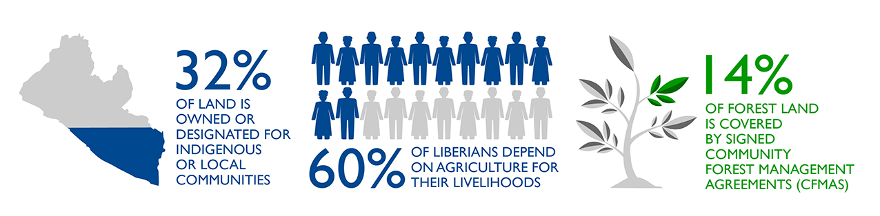
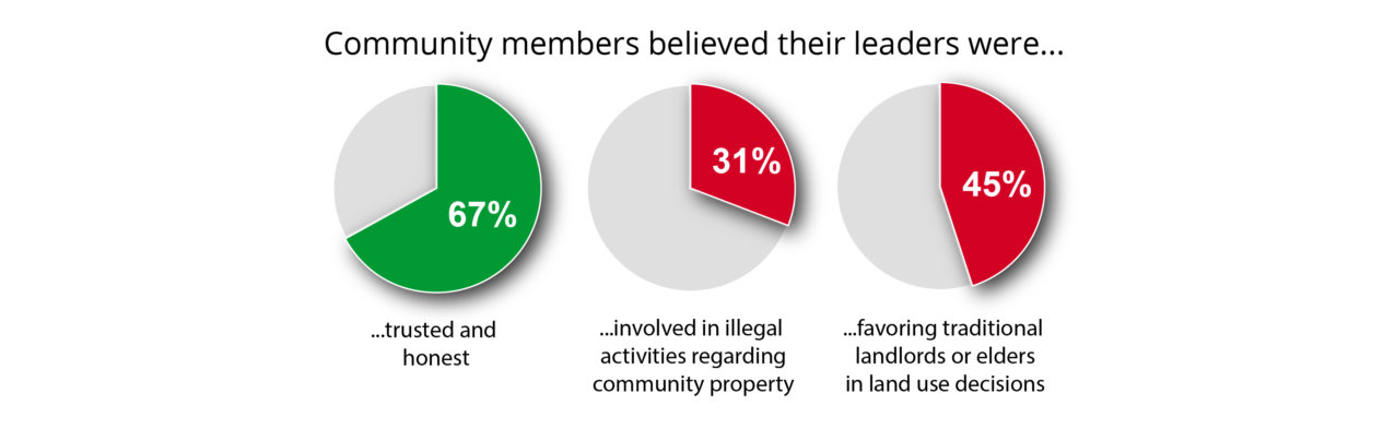
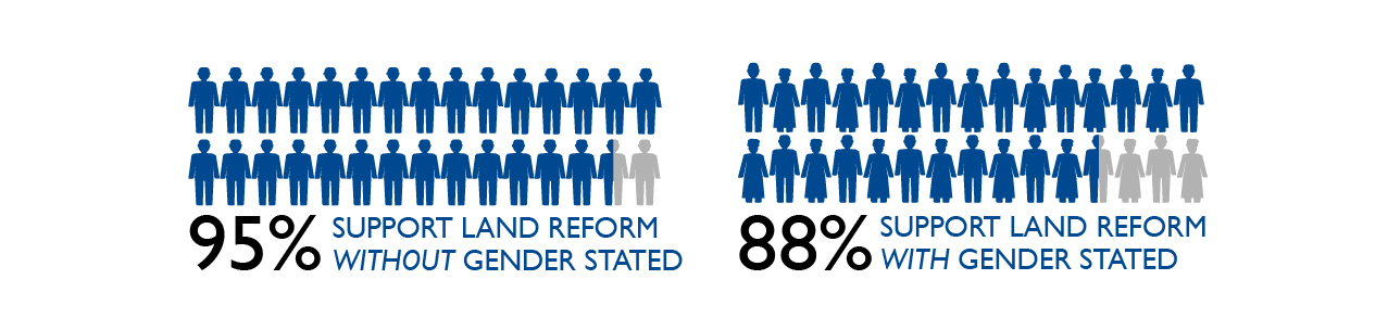
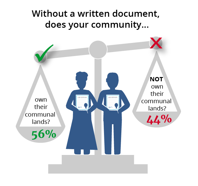
Baseline results indicated that respondents were divided on their knowledge of community property rights. Forty-four percent incorrectly stated that without a written document, the community did NOT own their communal lands.

Additionally, 54% of respondents stated that the Government of Liberia owns the community’s land and natural resources.  Given the current interpretations of Liberian law and policy, it is the community and NOT the government of Liberia that owns a community’s land and natural resources.

These findings confirmed that additional legal knowledge through CLPP could help community members more effectively claim their rights.

Tenure Security

Baseline findings also suggested that respondents were aware of threats to tenure security, largely due to unresolved boundary disagreements with neighboring communities. Approximately one quarter (24%) of community members stated that it was likely that neighboring communities would encroach on their land in the future and almost half of community members (43%) stated that they could only identify some of the boundaries of their community land.

For more information about baseline findings, see the CLPP Baseline Evaluation Report.

Land & Natural Resource Governance

The evaluation found that participation in CLPP is positively associated with perceptions of improved local land governance. As seen in the graph below, households in communities that participated in CLPP activities show a significant increase in their satisfaction, perceived accountability, capacity, and transparency of leaders.

Households in CLPP communities are also significantly more likely to report that their community has written land rules as a result of the bylaws drafting process, which about 90% of CLPP communities had started at the time of midline data collection. Households in CLPP communities also reported higher satisfaction with land rules. A group of youth in one CLPP community in Maryland explained new rules and regulations surrounding forest access in their town:

While evaluation findings show that households in CLPP communities are significantly more likely to participate in the creation of land rules, household participation levels in enforcing land rules fell across both households in CLPP communities and comparison communities.

The reason for these observed decreases in community participation in rule monitoring and enforcement could be that leaders were completing these tasks themselves more effectively, people were following the rules more (necessitating less enforcement), or that the program emboldened community members to oppose laws they consider ‘bad’.

Community Land & Legal Knowledge

There is strong qualitative evidence that CLPP’s boundary identification activities increased community members’ knowledge of community land boundaries. However, there are no statistically significant results in the survey data.

Tenure Security

To assess tenure security, the evaluation measured household perception of encroachment on communal land across a variety of actors (neighboring households, neighboring clans, elites, investors, and government officials).  The evaluation does not find clear evidence that CLPP had an impact on perceived tenure security or prevalence of land conflicts in the 10 months since the program began. One possible explanation for the lack of improvement on tenure security indicators might be that the program has not yet completed its activities.

A descriptive analysis for tenure security trends for communal land shows that fear of land expropriation by neighboring households and clans has decreased over time, but decreased more dramatically in comparison households versus CLPP households. This result is likely due to the program reviving a discussion of dormant land disputes and alerting community members of potential risks. If so, perceived tenure security may improve once the boundary harmonization processes are complete.

Additionally, fear of encroachment by elites and investors increased in both CLPP and comparison households, but this change is NOT statistically significant.  Concerns about elite or investor encroachment may stem from ongoing uncertainty around the status of the Land Rights bill. Although no concessions are operating in the study area, the lingering impact of large scale-land acquisitions in recent years may also play a role.

In contrast, community leaders in CLPP communities are more likely to say that the local government respects their land boundaries. A youth leader in a CLPP community in Lofa described how the local government assisted with a dispute with an investor:

Overall, the contradictory findings on the impacts of CLPP on tenure security perceptions indicate that evidence on this outcome is mixed and inconclusive.

Women

Evaluation findings show an increase across both CLPP communities and comparison communities in their knowledge of formal laws related to women’s inheritance. While women in CLPP communities are more likely to report that they attended a land meeting (68%) compared to women in comparison communities (57%), their overall decision-making authority is still limited. When households and leaders were asked to rank decision-making power by a variety of community members, women ranked far lower than other groups. Though women showed a small trend upward from baseline to midline, there was no significant difference between CLPP households and comparison households.

In addition to increased participation and knowledge about women’s land rights, CLPP’s theory of change includes a shift in gender norms. Without changes in norms, increased knowledge may not be sufficient to change behavior or outcomes. The evaluation used a survey experiment to test whether highlighting the women’s rights component of legal reforms affects a respondent’s support of the reform. Results indicated that respondents were less likely to be supportive of land reform if they were told that reform would involve giving women equal rights to inherit, own, use and sell land in their community. Overall, support for land reform in either scenario is still very high.

Given the difficulty in effecting gender norms, changing the gender balance of leadership positions will likely be a difficult barrier to overcome. The evaluation finds no change in the number of women serving in community leadership due to CLPP. The geographic distribution of women in leadership positions at midline is shown below.

Additionally, while male and female leaders expressed initial support for women’s equality, they later qualified their responses with a series of restrictions on women’s inheritance requirements, such as the requirement that women must have had children or marry her husband’s brother.

All photos by Kate Cummings / The Cloudburst Group.

Farmers Need to Start Seeing their Farms as a Business

Q&A with Mauricio López, Colombia’s National Chocolate Company’s Development Manager in Tolima

Mauricio López (R) explains a cacao grading card.

In 2017, USAID in partnership with Tolima’s regional government and mayors in southern Tolima established a Public-Private Partnership that would increase productivity in the cacao value chain. The PPP is valued at more than $5.6 million pesos and includes over 1,000 cacao producers as well as private sector partner Compañía Nacional de Chocolates (CNC). Mauricio López Gómez, CNC’s Purchasing and Agricultural Development Manager in Tolima, explains the challenges that cacao farmers face in southern Tolima, and how the private sector is now trying to provide them with reliable market access.

How does your company view the relationship between cacao growers and buyers?

The company’s main objective is to reach farmers directly, and for sales to be made between the farmer associations and the company, without having to resort to intermediaries. This ensure more money stays with the farmers.

How do you sustain this relationship?

In 1958, the company created an area called Purchasing and Agricultural Development. This department is responsible for marketing the product and is involved in developing projects for farmer associations and cacao growers throughout Colombia.

How does this approach fit within the public-private partnership?

Under the framework of the Public-Private Partnership, we offer support for everything related to technical assistance, training and workshops, nursery management and seeds and grafting. In addition to this, we work directly with farmer associations on marketing.

The Sweet Expression of Panela

How public policy tools and a public-private partnership is giving Cesar’s sugarcane farmers the chance to flourish.

La Panelita

Five years ago, sugarcane farmers in Cesar had few outlets for their products. Although Colombia is known for its panela—unrefined cane sugar—in this corner of the Caribbean, in the department of Cesar, sugarcane farmers have spent years either sending their cane harvests to processors down south or producing panela on a small scale for community consumption.

But the future of panela in Cesar looks bright. Thanks to a recent spur to market high-quality panela, the industriousness of an indigenous community, and a USAID partnership with the regional government, Cesar’s panela is going from local to national to international.

Four years ago, Samuel Coronel paid a neighbor US$40 for ten sugarcane cuttings to plant on some open land on his farm, located in the town of Los Encantos, high in the Sierra Perijá on the Colombia-Venezuela border. After one cycle, he multiplied coverage, and so on, until he eventually covered 20 hectares of land. A few years later, he purchased a mechanized cane mill, what he saw as a critical step to convince his neighbors of the potential of panela. Coronel’s hard work inspired neighbors to grow sugarcane, but they still needed market channels, certifications, group synergy and a regional and local government that would create an enabling environment.

Milling Organic

In 2017, as a result of collaboration between USAID and Cesar’s regional government, sugarcane growers, government entities and the private sector came together to outline a road map to build a prosperous panela value chain.

The resulting public-private partnership (PPP)—valued at nearly US$1 million—includes over 300 producer families and private sector players like top Colombian panela firm Doña Panela and the regional Chamber of Commerce. As a first step, USAID financed a value chain analysis of panela in Cesar, which identified the capacities of dozens of farmer cooperatives and evaluated more than 40 sugarcane mills in six municipalities.

At the center of the partnership is the indigenous Arhuaco farmer cooperative Seynekum, based in Pueblo Bello, which leads Cesar with an average annual production of 45 tons. In May 2017, Coronel and other farmers in the partnership visited the Seynekum milling and packaging operation to learn how Seynekum, in just seven years, went from a small-scale farm to becoming Colombia’s only organic and fair-trade certified panela producer.

“We believe that growers must stop seeing the cane as their final product, and instead see panela as a way to add value and the best way to complement their coffee crops. With panela, they have a product to market for the other eight months of the year,” says Claribeth Navarro, legal advisor and president of Seynekum.

After all, what is coffee without panela to sweeten it? Santander-based Doña Panela previously helped Seynekum reach its potential and continues to buy and market Seynekum’s organic panela under the Doña Panela label. This year, Seynekum created its own brand and is trying to replicate the model with third-party growers like Coronel. Since Seynekum has certified its panela with Colombia’s food regulatory authority, hundreds of growers stand to benefit via Seynekum. If good enough, their panela could finally travel to markets beyond their communities.

“As campesinos, we see the purchasing prices of coffee and panela falling, but when we go into the store, the consumer continues to pay the same price. It’s difficult to make any progress in this panorama,” says Samuel Coronel. “Partnering with Seynekum allows us to cross that barrier and improve production.” Seynekum recently visited Coronel’s mill and outlined what steps needed to be taken to meet the organic and free trade requirements.

USAID-facilitated PPPs in Cesar have mobilized approximately US$12.7 million, benefiting more than 3,000 farmers.
Samuel Coronel's mill.
Samuel Coronel with freshly milled cane juice, on his farm in Los Encatos, high in the Sierra Perijá, Cesar.

Six Lessons from the First Investor Survey on Land Rights

Last year, USAID and our partners set out to answer a critical question that is essential to informing how we work with businesses, communities and governments on land rights and economic growth: how does the private sector think about and deal with risks to their investments stemming from unclear or weak land tenure and property rights?

To date, there had been no systematic study of how investors and business operators actually assess and seek to mitigate land tenure risks. Without a clear understanding of these issues, USAID and other development agencies are limited in our efforts to develop policies, programs and partnerships that create win-win scenarios for both businesses and local communities.

Read the full piece on the Global Landscapes Forum website.

Land Formalization Pilot in Ovejas

Over ten months, the USAID-funded Massive Land Formalization Pilot teams work six days a week, 6am-3pm, walking off every single property, parcel, & farm in an area measuring 500sq. kilometers. At 200m above sea level, 100 kilometers from the Caribbean ocean, the terrain is hot, humid, buggy, muddy, rainy, boggy, and dotted with unfriendly plants that sting, stick, and poke, plenty of mosquitoes, spiders, scorpions, an odd snake or two. Mid day sun, brutal. Rainy season, relentless.

The teams–many of whom grew up in these parts–deal not only with extreme climate conditions, but unpredictable landowners, who never show up. Technology that doesn’t always respond. Dead batteries at the end of the day.

Land conflicts: neighbors, families, property boundaries, divisions, forgotten inheritances, and the never-ending saga of a government that has completely abandoned land administration for at least the last 20 years.

This is the face of land formalization in 2018 Colombia!


USAID Land Champion: Jennifer Chow

Jennifer Chow is a Senior Policy Advisor in the Global Engagement and Strategy Office in USAID’s Bureau for Food Security. We spoke to her about why land is important to improving food security and advancing development.

Can you tell us a little bit about yourself?

I provide policy and strategic guidance on global food security issues with US Government leadership, other donors, international organizations and other development partners. I also provide input to help shape international norm-setting principles and voluntary guidelines. I try to make sure this policy guidance reflects the work of USAID on the ground and the development priorities of our government, and in turn that our work reflects global priorities and best practices, and that we at USAID focus on emerging issues so that our resources and efforts are effective and well-coordinated.

A lot of this work includes finding common ground and identifying opportunities to work better with other development partners (as well as within our own government) and building trust and long-term working relationships. I also focus on addressing issues such as resource governance, land tenure & property rights and responsible investment as part of a holistic global food security agenda.

Why is land important to USAID?

In general, I think land represents at least two critical things to everyone: 1) it is an economic asset which can be transacted (bought, sold, rented, mortgaged, etc) and 2) it is a livelihood asset which can provide shelter, a home, food, storage, safety & protection and other benefits.

Investments in land are often part of the essential economic stability and food security picture for families, communities and countries, which makes land an important part of our larger development vision. The support we provide in the countries where we work and the partnerships we shape can be critically altered by policies or dynamics around land.

What is the connection between land tenure and food security?

One simple example is that tenure security can lead to investments to improve the land as well as increase food productivity. For farmers in particular, it’s important to have a stake in the land and a sense of security that you will actually be able to reap what you sow. It’s important to understand that nurturing the soil will yield benefits next season, that you can treat the land as an investment for future generations. All of these factors fundamentally motivate farmers (and others) to build sustainable irrigation and crop rotation systems, or use other climate-smart and holistic agriculture practices involving precision farming, different energy use, tillage and fertilizer practices. Land, and the soil and other conditions related to it, are critical for growing food, for contributing to reliable sources of nutrition and income and for developing or contributing to trade and markets.

How is USAID working to fight hunger, strengthen land rights, and/or support responsible investments?

USAID provides technical expertise and capacity building to help governments structure, enact and implement policies and procedures related to land and resource rights. We encourage inclusivity, help connect people to processes and facilitate discussions. We also create and provide guidelines and checklists for companies, communities and governments to approach land rights and responsible investment issues in a comprehensive manner. We incentivize this behavior through partnerships with companies, non-governmental organizations and government partners; through programs on the ground; through monitoring and evaluation; and through continuously pushing for transparency and consistency.

Through extensive consultation and learning from past experience, including from the first five years of the Feed the Future initiative, USAID developed a new Global Food Security Strategy for 2017-2021. It represents a whole-of-government approach with agency-specific implementation plans. It has Congressional support (and mandates) via the Global Food Security Act of 2016. It goes into detail about how we will contribute to the achievement of global food security and the Sustainable Development Goals while elevating nutrition and resilience and emphasizing market-led development.

USAID also coordinates with other development partners on land mapping activities and on using surveying tools and data to inform better policies and programs. We also partner with companies and NGOs to pilot the implementation of responsible investment guidelines, to document concerns and needs from various stakeholders and to develop win-win scenarios for investors and communities.