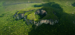
Q&A with Ayda Garzon, head of Chiribiquete National Park, Colombia
The head of the Serranía de Chiribiquete National Park within Colombia’s National Parks Authority (PNN), Ayda Garzón, manages the preservation of more than 4 million hectares of protected area, including the protection of indigenous communities, archeological heritage, and the rich biodiversity held within. At the same time, rampant deforestation continues to threaten many parts of the park. In this interview, Garzón talks about the drivers of deforestation, coordinated efforts with the government, and USAID’s support to improve land governance around the park.
What are the challenges of managing and protecting the Serrania de Chiribiquete National Park?
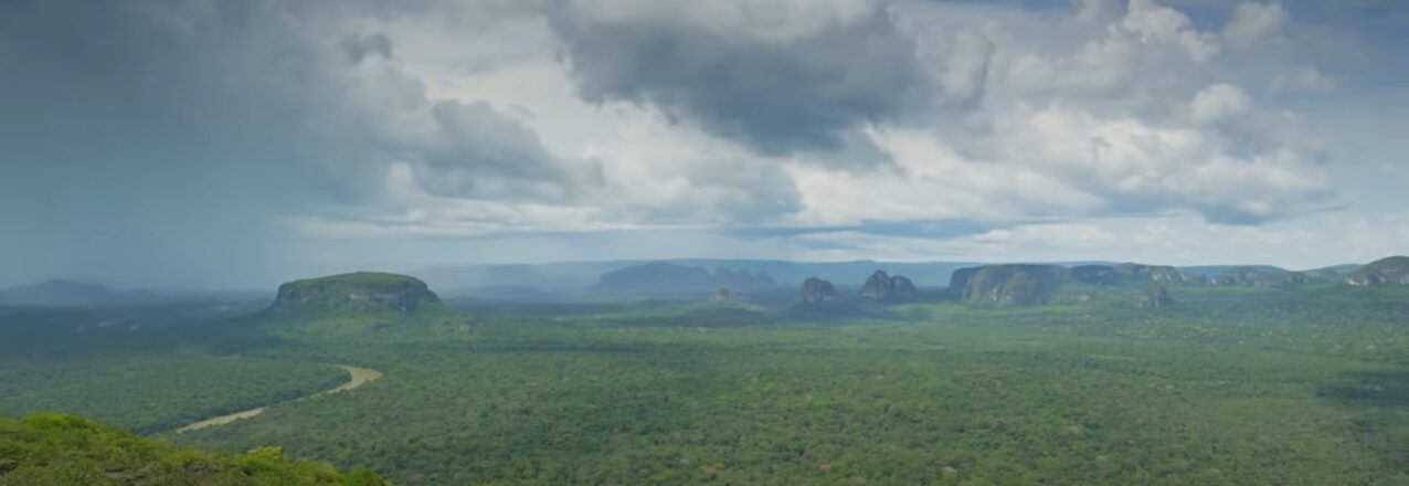
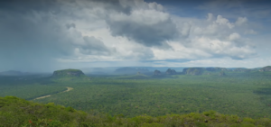
They are many and very big, almost proportional to Chiribiquete’s size. It is the largest protected land area in Colombia and the world, located in the departments of Caquetá and Guaviare, with the presence of indigenous and farmer communities. The northern section of the park borders the deforestation arc of the Amazon, and in the southern part, the park borders indigenous reservations, however there, the area retains a high level of conservation.
What are the factors that contribute to the deforestation of the park?
 Through our analysis, we understand that deforestation in Chiribiquete is closely linked to land access and property issues and land grabbing. We see five big deforestation hotspots inside Chiribiquete that correspond to two areas in San Vicente del Caguán, two sections going towards San José del Guaviare, and one area which is the northern border of the Yaguará II indigenous reservation. Then we have zones such as San Miguel that, although they are not very large, already show evidence of deforestation.
Does deforestation increase illegal cattle ranching and illegal crops in the park?
Once deforestation processes have begun, roads appear connecting plots of land, and after two or three years, the cows start to appear. In the last year, cattle ranching increased twofold. Until a year ago, there were not more than 50 hectares of illicit crops in Chiribiquete, but since then we have also seen an increase.
What are the tools that the government needs to fight this?
A vital element is ensuring that the communities trust the government and feel they are and will continue to be taken care of. The lack of the government presence leads to communities recognizing the presence of FARC dissidents as the ones who govern the land. The government needs to make an effort to take care of these populations, and in this way build peace.
Do you think that land use planning contributes to the fight against deforestation?
 I think that in the case of the areas around the national park, in theory it can contribute. We have the designations, such as the parks and forest reserves, but I think forest reserves have lost their validity, despite being a mechanism to ensure that the forests can be preserved and exploited in a sustainable way. With Colombia’s issues in terms of land access for rural communities, deforestation is a result not only of people colonizing the forests, but in many cases, it’s a result of government policies. In the case of the Amazon Forest Reserve, the government directed and promoted new colonies and occupation, and they did it with counterproductive policies that people still have ingrained in their heads in terms of what is required for someone to consider themselves the owner of a piece of land. So today, people who do not have grass or cows, do not feel they are owners. So, regulations and land use planning exist, but in the end, what transforms the land are the people who do not have the right tools or knowledge and receive no support from the government.
The USAID Land for Prosperity Activity is supporting the government to survey the park´s boundaries and its vicinity to update the rural cadaster for the first time. Why is this important?
For us, having an updated cadaster is interesting for several reasons. It forces us to work with government land entities like the rural cadaster authority IGAC. It also forces us to work with municipality leaders on a complicated topic, which is land. And once the cadaster of neighboring municipalities have also been updated, then the information must be synchronized. In addition, we already monitor deforestation, but our tools do not have the same level of detail as the land survey for the rural cadaster. For us, this is a big win.
Does the designation of national park make your job difficult?
What we do is protect and conserve that natural foundation, the base that supports all development, and it is difficult for these areas to be understood as opportunities. Sadly, when we talk to the mayors, the first thing they say is that having a protected area is the worst thing that can happen to them, because they cannot collect land taxes, for example, and they cannot intervene in the areas in any way. And this is not only in municipal or departmental administrations, but a lot of national entities also see national parks this way. Therefore, it is a challenge to promote protected areas and make people see them, Chiribiquete in particular, as drivers for development, as partners for the development of a municipality or department.
Do you think that USAID is contributing to conservation?
 I think they are on multiple fronts, for example, in terms of prevention, patrolling, and control, and the application of environmental law. USAID has a number of actions and programs that are strengthening government entities, and they are carrying out projects and providing tools to the communities that allow them to make better use of their land. USAID has initiatives around communication and awareness raising that I think are vital, and that helps to bring that knowledge and that work closer to the communities.
How urgent is it to stop deforestation inside the park?
 If we don’t coordinate efforts and work with the communities in the northern part, Chiribiquete does not have a high rate of survival in the medium term. The process of deforestation moves fast, and every day there is more transformation. If we don’t make the indigenous communities who are protecting the southern parts of the park our natural partners, it is very likely that a time will come when there will also be deforestation in that region. So, our first challenge is to work with the communities, to make them our natural partners for conservation. Without discriminating between indigenous and farmer communities but including everyone.