Legitimate Land Rights: You Asked We Answered

The Legitimate Land Rights event on September 15 inspired a lot of online discussion and we were unable to answer all of the questions from the online audience during the event. Today, we are sharing our answers to some of the most interesting questions:

Question: It would be interesting to understand the international perspective on what constitute legitimate land rights; any thoughts?

Answer: As you might expect there is a rather wide spectrum of opinion about what constitutes a “legitimate” land right. International best practice holds that women have legitimate rights to land and resources as owners in their own right, through marriage or through inheritance, and that communities that hold recognized, traditional (or customary) rights to land and resources also have legitimate rights. Also at the international level, indigenous peoples are recognized to have important, and legitimate, rights to land and resources. However, there may be disagreement about which groups should be considered as “indigenous peoples.” There is less consensus on the status of slum dwellers and if they do, or do not, hold legitimate land rights.

Question: Legitimacy is an interesting term. Who determines legitimacy? Related to validity: what is valid information? This is a problem across scales and need to be incorporated into the idea of cross scale coherence.

Answer: What counts as a legitimate land right might be determined by national legislation, by international agreement, or by social norms and customs. As a result, the kinds of information that are required to determine legitimacy may include things like: traditional memory and oral evidence, formalized documentation found in cadastral offices (including certificates of occupancy/use and title deeds), or information collected by private efforts of civil society organizations. Crowd-sourced information about legitimate land holders may become an increasingly important font of material on the issue of legitimacy. While there is no global, standardized set of land rights information, if the Sustainable Development Goals include targets related to land standardized data will need to be collected to track progress towards goals of providing more secure rights to land to women and men (and legal entities).

Question: Are local legitimate land rights recognized when land was taken for state projects – abandoned – then offered to investors?

Answer: The answer to this question is context specific. Some investors will carry out appropriate due diligence and work to identify and recognize pre-existing legitimate land rights before an investment is made. In other cases, investors will not do this, or will not be guided by governments to do this, creating the potential for harm to local people and to the investor. The kinds of legacy issues this question points to are challenging and recent research on the topic provides helpful recommendations on how best to avoid harm. Please see here.

Question: For Kate Mathias of Illovo Sugar Ltd.: What can an investor possibly do in a situation where the government has leased land to the investor by saying it is unregistered and part of the public domain, but customary land users still claim it as “their” land in opposition to an official government decision?

Answer: It is a difficult situation as the community is effectively questioning the legitimacy of formal land rights as communicated by its government. Land use issues should be identified during the Environmental and Social Impact Assessment and if required it should be registered as a risk to the investment. The company should engage with the communities/stakeholders involved to try to establish if a mutually acceptable solution can be found perhaps by incorporating the customary land users into the supply chain or through meeting the needs of the community through other social support mechanisms. If however a mutual solution cannot be agreed then the company must make a decision around the risk to the investment and could potentially walk away from that land area and discuss alternatives with the government using the ESIA as proof of the risk.

Question: For David Grossman of International City/County Management Association: Will individuals accept property title “proxies” as legitimate land rights? How might engaging banks help?

Answer: Although tax declarations are not proof of ownership, many private individuals accept land title proxies for land transactions, such as sales and mortgages, as collateral for other transactions. For example, in the Philippines, government banks, Development Bank of the Philippines (DBP), and Land Bank accept them and some local governments recognize them absent the best proof of ownership. Land titles apart from tax declarations, tax receipts, and payments on property can also serve as proxies.

Ethiopia to Develop a Comprehensive National Land Use Policy

On June 9, 2016, Hailemariam Desalegn, Ethiopia’s Prime Minister, announced the decision to develop a comprehensive national land use policy that provides a framework for a holistic and sustainable use of land to achieve social and economic development.

“Land use policy is at the heart of all development endeavors that aim to bring about economic transformation. Our success in achieving the transformation depends on the effective use of our land according to its potential,” the Prime Minister declared at a high-level discussion held in his office.

Accordingly, Desalegn ordered the development of a comprehensive national land use policy immediately, to be followed by a national land use plan within the coming three years. He urged all federal and regional government officials to ensure that the country’s land and natural resources are put to their best use until the policy comes into effect and the national land use plan is implemented.

Four peer-reviewed papers, which provide insights on the country’s land use trends, policy issues as well as key challenges facing the country, were also presented at the discussion. The papers include an analysis of landscape transformation and subsequent changes observed on natural resources and socioeconomic development in Ethiopia in the last three decades; a review of current Ethiopian policies and laws on land use; international experience on preparing and implementing national land use policies and their impacts on socioeconomic development; and the importance of a sound and robust land use policy.

More than 250 participants attended the high-level event, including ministers, regional presidents, the Prime Minister’s senior advisors and leaders of renowned academic institutions in Ethiopia.

The event concluded with the establishment of two committees to lead the policy development. The first is a technical committee composed of representatives from all ministries and government agencies that have a mandate to use or regulate the use of land and natural resources. Under the auspices and coordination of the Ethiopian Ministry of Agriculture and Natural Resources, this committee is tasked with preparing a draft of the policy by bringing together expertise and perspectives and priorities of all sectors on land use. The second is a high-level ministerial committee comprised of eight ministers who will oversee the activities of the technical committee and the formulation of a sound and robust national land use policy.

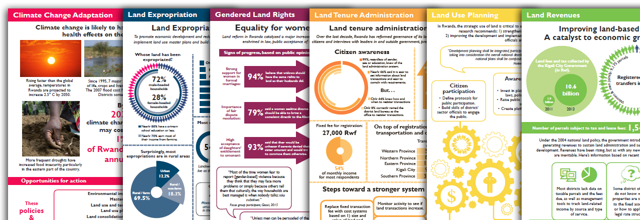
Six New Infographics from USAID’s Rwanda LAND Project

Since its inception, the USAID Rwanda LAND Project has produced a rich body of research on land issues in Rwanda. However, the project identified a need to broaden dissemination of the information and policy recommendations contained in the research. With this in mind, the LAND Project produced a series of six infographics targeting policymakers and land-related organizations on the following themes:

The infographics are available in English. The project also produced and broadcasted a six episode radio miniseries in Kinyarwanda to share information derived from the research with ordinary citizens.

Land Certification in Ethiopia: Lessons from USAID’s First Completed Land Sector Impact Evaluation

With a predominantly agrarian economy, land has been and will continue to be an important production asset for both farmers and pastoralists in Ethiopia. After a long period of feudal and customary land ownership, all land became public property in 1975 subject to long-term use rights. Still, a number of challenges to tenure security remained, and in the late 1990s, the Government of Ethiopia (GOE) launched the first ever land certification program to register farmlands held by rural households. Although this “first level” land certification had a number of important impacts on tenure security and land use practices on farms, a joint GOE-USAID assessment in 2004 indicated a need to improve tenure security by introducing cadastral maps and modern land registration.

Since 2005, USAID has invested a total of $20 million, through three consecutive programs, to strengthen land rights, build capacity, and map and certify individual and community lands across much of Ethiopia. The first two programs—the Ethiopia Land Tenure and Administration Program (ELTAP – 2005-2008) and the Ethiopia Land Administration Strengthening Program (ELAP – 2008-2013)—piloted and introduced improved second level land certification with cadastral maps in select woredas (districts) of the four highlands regions (Amhara; Oromia; Southern Nations, Nationalities, and Peoples; and Tigray).

Encouraged by the results of these projects, the GOE expanded second level certification in partnership with other donors, including the governments of Finland, Sweden, and the United Kingdom (UK), and the World Bank, and moved to invest an additional $150 million to expand second level land certification for millions of small-scale farmers.

For its part, while USAID has shifted its focus to registering communal land in pastoral areas, we decided to conduct an impact evaluation of ELTAP and ELAP to learn more about the impacts of second level land certification on women’s rights, credit and land access, and perceptions of tenure security and inform our support to land certification in Ethiopia and many other countries. Despite the significant effort associated with the impact evaluation, I am happy that we made a very important decision to invest in this study.

Firstly, the exercise allowed our Mission to learn more about impact evaluation design and execution. Impact evaluations need carefully designed scopes of work, a sound hypothesis and assumptions, precisely identified variables and indicators, and well-crafted surveying tools. We learned a lot from the endline process and even thought in retrospect that the baseline could have been done a bit differently. For example, we learned how important it is to ask questions in a way that small-scale farmers can easily answer, to complete baseline data collection before field activities begin, and to incorporate expertise from Government officials, academic experts, and other development partners.

We also learned how critical it is to carefully review the evaluation design in light of the program implementation process so that the design can be revised to capture any changes in implementation not anticipated in the original evaluation design. For example, since the delivery of certificates is beyond the manageable interest of our projects, many of our beneficiaries had their land surveyed but had not yet received a certificate at the time of the endline. As such, we revised the evaluation design to study whether having your land surveyed alone as compared to also receiving a certificate affects farmers’ outcomes. The support provided by our colleagues in Washington helped move the impact evaluation in the right direction and get it done on time.

Secondly, the impact evaluation also identified critical lessons from our programs within a short interval after ELTAP and ELAP implementation. For example, we found that second level land certification led to a 10 % increase in the likelihood of accessing credit, an 11 % increase in landholding, a 44 % increase in women’s decision- making over crops, and an 11% increase in the likelihood of households believing they have the right to bequeath land to their heirs. Given that farmers already enjoyed improved tenure security while transitioning from no certification to first level land certification, second level certification might not have been expected to show radical improvements in tenure security. Nonetheless, the evaluation highlighted other complementary reforms, for example to mortgage and rental regulations, that could increase the impact of second level land certification on farmers’ investments and livelihoods.

Finally, I know that USAID, the Government of Ethiopia, and other development partners are already considering the results of this impact evaluation and how to integrate them into the design of future programs. For instance, the evaluation recommends further legal reforms to allow land to be used as collateral to enable farmers to benefit from increased credit access with their land certificates. In reviewing the evaluation findings, the GOE noted that their new project with the UK is testing pilots that allow for mortgaging land use rights, so our findings support this theory of change. There are likely to be many opportunities to support other complementary reforms in on-going and future land administration programs to ensure that the benefits from second level land certification are fully realized and sustained.

Read more: